

Occasional Showers/Storms Through Wednesday
RADAR CHECK: At mid-afternoon rain is concentrated over parts of East and South Alabama; heavier downpours are lined up in the broad zone from Mobile to Dothan, and northeast of Birmingham. The sky is mostly cloudy over the rest of the state, although the sun is out over parts of West and Southeast Alabama. Temperatures are well below average, with readings around 80 degrees at most locations. We will maintain the chance of showers tonight in the moist, unstable air over Alabama and the Deep South.
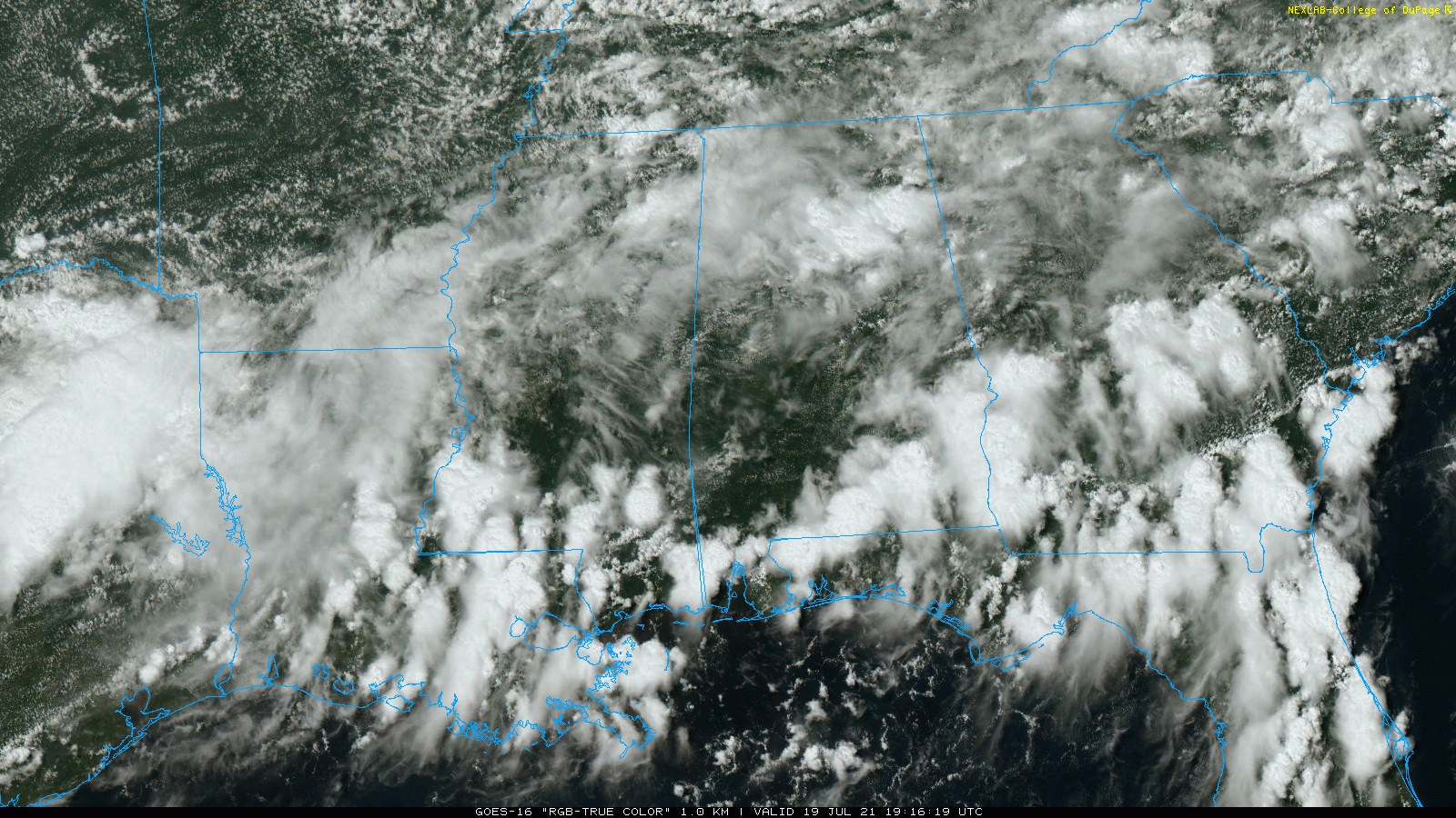
We note the NWS in Huntsville maintains a flash flood watch for the Tennessee Valley of North Alabama tonight. But, stronger storms could dump heavy rain on any part Alabama in this kind of airmass.
TOMORROW THROUGH THURSDAY: The weather will remain unsettled with the upper trough in place. Tomorrow will be much like today… mostly cloudy with occasional showers and thunderstorms. Temperatures won’t get past the low 80s in most communities with only a limited amount of sun. Then on Wednesday and Thursday, the sky will be occasionally cloudy both days with scattered to numerous showers and thunderstorms. Afternoon highs will be in the low to mid 80s.
FRIDAY AND THE WEEKEND: We expect a mix of sun and clouds on these three days with scattered showers and thunderstorms, most numerous during the afternoon and evening hours, mostly between 1:00 and 11:00 p.m. The chance of any one spot getting wet Friday and Saturday is 45-55 percent, dropping to 30-40 percent Sunday. Heat levels will be creeping up; we expect upper 80s Friday and Saturday, and low 90s are possible by Sunday afternoon as the showers become fewer in number.
NEXT WEEK: Global models continue to suggest an upper ridge will begin to nose into our region from west, meaning the weather will trend hotter and drier. Still, we will have the risk of a few random, pop-up afternoon storms each day, but we should see a decent amount of sun through the week with highs mostly in the low 90s. See the Weather Xtreme video for maps, graphics, and more details.
TROPICS: The Atlantic basin is very quiet, and tropical storm formation is not expected through the next five to seven days. The peak of the season comes in August, September, and early October most years.
RAIN UPDATE: Here are rain totals since January 1, and the departure from average…
Mobile 48.50″ (+10.78″)
Tuscaloosa 44.31″ (+13.04″)
Birmingham 40.04″ (+6.42″)
Huntsville 38.02″ (+6.09″)
Dothan 37.56″ (+6.98″)
Muscle Shoals 35.94″ (+3.95″)
Montgomery 32.28″ (+2.55″)
Anniston 31.52″ (+0.29″)
ON THIS DATE IN 1997: Hurricane Danny moved to the mouth of Mobile Bay near Fort Morgan just before dawn. The hurricane then drifted into southern Mobile Bay and stalled… it finally made landfall near Mullet Point midday on the 19th as a category one Hurricane. Danny drifted across Baldwin County through the rest of the day on the 19th and into the morning of the 20th. The weakening cyclone finally turned north late in the day and moved over the extreme northwest Florida panhandle before proceeding to move north and northeast over Alabama for the next 2 days.
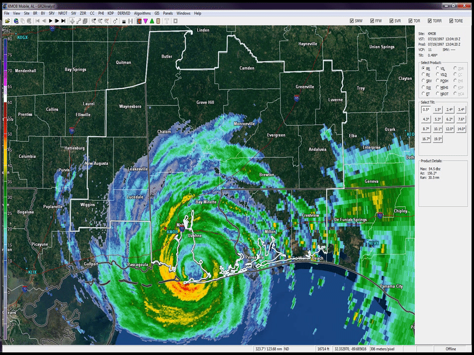
Radar estimated an incredible 43 inches of storm total rain over the open water in Mobile Bay. Observing sites reported 30-40 inches across the area with Dauphin Island reporting 36.71 inches. Numerous roads were inundated and impassable for days after Hurricane Danny. Record flooding caused major damage to homes along the Fowl River in Mobile County and the Fish River in Baldwin County.
ON THIS DATE IN 2006: A derecho impacted a sellout crowd of almost 44,000 St. Louis Cardinals fans, packed into the new Busch Stadium. Winds of about 80 mph whirled around the St. Louis area, sending the fans running for shelter. The winds knocked out power and broke windows out of the press box. Nearly two minutes after the winds began at 100 mph, they stopped, and it started to rain. In all, about 30 people were injured at the stadium.
BEACH FORECAST: Click here to see the AlabamaWx Beach Forecast Center page.
WEATHER BRAINS: Don’t forget you can listen to our weekly 90 minute show anytime on your favorite podcast app. This is the show all about weather featuring many familiar voices, including our meteorologists here at ABC 33/40.
CONNECT: You can find me on all of the major social networks…
Look for the next Weather Xtreme video here by 6:00 a.m. tomorrow…
Category: Alabama's Weather, ALL POSTS, Weather Xtreme Videos
About the Author (Author Profile)
James Spann is one of the most recognized and trusted television meteorologists in the industry. He holds the AMS CCM designation and television seals from the AMS and NWA. He is a past winner of the Broadcast Meteorologist of the Year from both professional organizations.Subscribe
If you enjoyed this article, subscribe to receive more just like it.


