

Midday Nowcast: More Heavy Rain Ahead
New day, same forecast as an upper level trough and a meandering surface front continue to produce widespread and numerous showers and storms across Alabama, and much of the Southeast.
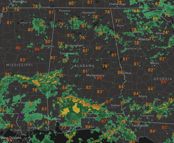
In Central Alabama, showers are starting to develop and these will continue to expand in coverage and intensity as we head into the afternoon hours. The more intense activity across South Alabama, but it’s working its way north through the state today.
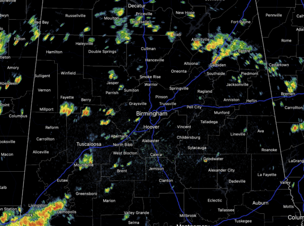
Rain is possible at any time, anywhere, but we see more thunderstorms during the afternoon and evening hours, and these continue to cause areas of flash flooding as well as produce lots of lightning. On average, rainfall totals the next 48 hours will be in the 1-3” range, but if you fine yourself under one of the training thunderstorms, rainfall totals could exceed five inches. With the clouds and rain, temperatures will hold in the 70s and 80s. Not much change in the forecast for tomorrow.
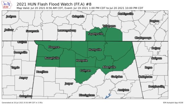
FLASH FLOOD WATCH: Both the NWS Office in Huntsville and Birmingham have expanded and extended the Flash Flood Watch for much of North and Central Alabama.
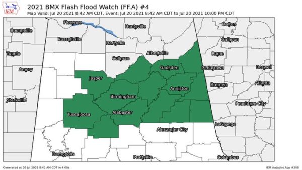
Expected heavy rainfall across the watch area may result in localized flash flooding, especially in urban, low-lying and poor drainage areas. You should monitor later forecasts and be prepared to take action should Flash Flood Warnings be issued. Again, if you encounter flood waters PLEASE DO NOT DRIVE THROUGH THEM, TURN AROUND, DON’T DROWN!!!
THURSDAY/FRIDAY: For now the trough begins to lifts out of the area by late Wednesday, but tropical air will remain in place, so rain chances will be a tad lower, but still each day will feature scattered to perhaps numerous showers and storms. Rain chances these two days look to be in the 40-60% range. Expect partly sunny days with highs in the mid to upper 80s, which remain below average for July in Alabama.
IN THE TROPICS: For the North Atlantic, Caribbean Sea, and the Gulf of Mexico: Tropical cyclone formation is not expected this week as there are no areas of interest.
BEACH FORECAST CENTER: Get the latest weather and rip current forecasts for the beaches from Fort Morgan to Panama City on our Beach Forecast Center page. There, you can select the forecast of the region that you are interested in visiting.
WORLD TEMPERATURE EXTREMES: Over the last 24 hours, the highest observation outside the U.S. was 120.6F at Reggane, Algeria. The lowest observation was -92.7F at Ago-4, Antarctica.
CONTIGUOUS TEMPERATURE EXTREMES: Over the last 24 hours, the highest observation was 117F at Death Valley, CA. The lowest observation was 36F at Peter Sinks, UT.
Category: Alabama's Weather, ALL POSTS
About the Author (Author Profile)
Macon, Georgia Television Chief Meteorologist, Birmingham native, and long time Contributor on AlabamaWX. Stormchaser. I did not choose Weather, it chose Me. College Football Fanatic. @Ryan_StinnetSubscribe
If you enjoyed this article, subscribe to receive more just like it.


