

Midday Nowcast: Hazy, Hot, and Humid
The Heat Advisory continues today and has been extended through Saturday evening as the combination of hot temperatures and high humidity is allowing heat index values to climb over 105° at times and could be as high as 110°…Levels this highs are downright dangerous, even for us southerners that are use to the heat and humidity.
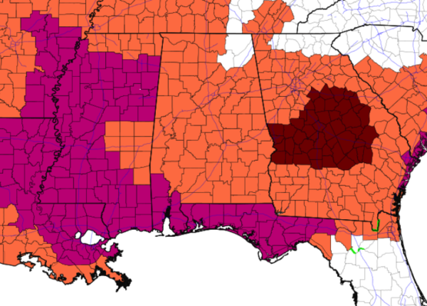
Additionally, we note, an Excessive Heat Warning is in effect for Southwest Alabama and the Florida Panhandle, where heat index values could be as high as 115°.
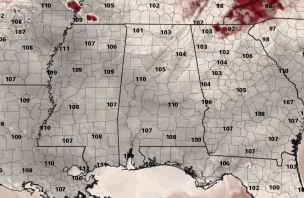
With more sun than clouds, actual air temperatures are heading into the mid to upper 90s, and both today and tomorrow, there could be some low 100s in those hotter spots.
ANY HEAT RELIEF?: We are watching a frontal boundary to our north, which has been responsible for quite a bit of severe weather this week from the Midwest and Great Lakes, east into the Northeast and Mid-Atlantic. It is slowly sinking south the next few days, and its proximity to the region could allow for a few showers and storms across North and Northeast Alabama later today. Tomorrow, the front inches closer so clouds and rain chances will be higher areawide, and we will mention isolated to perhaps scattered shower and storms, but most locations will stay dry and continue to bake in the Alabama heat for another day.
RAIN CHANCES INCREASE: On Sunday, with front making it into Alabama, rain chances will be much higher and we are forecasting numerous showers and storms by the afternoon and evening hours. Sunday will still be hot, with highs in the mid-90s, and we could see the Heat Advisory extended into Sunday for some spots, but many locations will see showers and storms. The rain and storms will continue into Sunday night and through the day Monday. Highs on Monday will be much cooler with low and mid 80s expected due to the clouds and rain.
IN THE TROPICS: For the North Atlantic, Caribbean Sea, and the Gulf of Mexico: Tropical cyclone formation is not expected during the next 5 days.
BEACH FORECAST CENTER: Get the latest weather and rip current forecasts for the beaches from Fort Morgan to Panama City on our Beach Forecast Center page. There, you can select the forecast of the region that you are interested in visiting.
WORLD TEMPERATURE EXTREMES: Over the last 24 hours, the highest observation outside the U.S. was 129.7F at Colinas Do Tocantins, Brazil. The lowest observation was -111.3F at Vostok, Antarctica.
CONTIGUOUS TEMPERATURE EXTREMES: Over the last 24 hours, the highest observation was 117F at Death Valley and Ocotillo Wells, CA. The lowest observation was 35F at Estcourt Station, ME.
WEATHER ON THIS DATE IN 1979: A forty-minute hailstorm bombed Fort Collins, CO, with baseball to softball size hail. Two thousand homes and 2500 automobiles were damaged, and about 25 persons were injured, mainly when hit on the head by the huge stones. A three month old baby died later of injuries.
Category: Alabama's Weather, ALL POSTS
About the Author (Author Profile)
Macon, Georgia Television Chief Meteorologist, Birmingham native, and long time Contributor on AlabamaWX. Stormchaser. I did not choose Weather, it chose Me. College Football Fanatic. @Ryan_StinnetSubscribe
If you enjoyed this article, subscribe to receive more just like it.


