

SPC Introduces a Marginal Risk for Severe Storms for the Northern Portions of North/Central Alabama
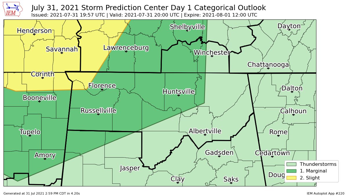
The SPC has introduced a Marginal Risk for severe storms for much of the western 2/3rds of North Alabama and the extreme northwestern corner of Central Alabama for the potential of an MCS that is forecast to move into the area later this evening. A Slight Risk is up for the extreme western portions of Lauderdale County and the extreme northwestern corner of Colbert County. Here is the text from the latest Day One Outlook from the SPC:
A cluster of thunderstorms could continue to evolve and pose a risk for damaging wind gusts across the Missouri Boot Heel vicinity through western Tennessee and adjacent portions of the middle Mississippi Valley into this evening.
Categorical and probabilistic lines have been adjusted, mainly to account for the progression of synoptic and sub-synoptic features and current trends concerning destabilization.
Across the middle Mississippi Valley vicinity, a small area of vigorous thunderstorm development appears to be undergoing at least some upscale growth, with enough of a cold pool to support further expansion and intensification, given at least modest southerly inflow of seasonably warm and very moist boundary-layer air.
Modest west-northwesterly deep layer mean flow on the order of 20-30 kt is contributing to a southward propagation, but it appears that activity is tending to propagate around the northeastern periphery of a lingering mid-level high centered over the Red River Valley, given weak supporting large-scale forcing for ascent. Although it is not entirely certain that mid-level inhibition will not ultimately suppress this activity, current trends, potential instability and time of day suggest that it may persevere, with potential to evolve into a more substantive risk for damaging surface gusts.
Based on current south-southeasterly propagation, the leading edge of the activity appears likely to reach the Tennessee/Mississippi border by around 01-02Z. Severe probabilities have been adjusted to account for this, as well as the potential for at least some continuing upscale growth and forward acceleration.
Category: Alabama's Weather, ALL POSTS, Severe Weather
About the Author (Author Profile)
Scott Martin is an operational meteorologist, professional graphic artist, musician, husband, and father. Not only is Scott a member of the National Weather Association, but he is also the Central Alabama Chapter of the NWA president. Scott is also the co-founder of Racecast Weather, which provides forecasts for many racing series across the USA. He also supplies forecasts for the BassMaster Elite Series events including the BassMaster Classic.Subscribe
If you enjoyed this article, subscribe to receive more just like it.


