

Midday Nowcast: Watching the Radar
A rare mid-summer front continues to slowly sink south through the state today. This boundary will be the focal point for numerous showers and storms today and tonight across the state. With the clouds and rain, the heat is not an issue today or really for the rest of the week, highs today are in the low to mid 80s across North/Central Alabama.
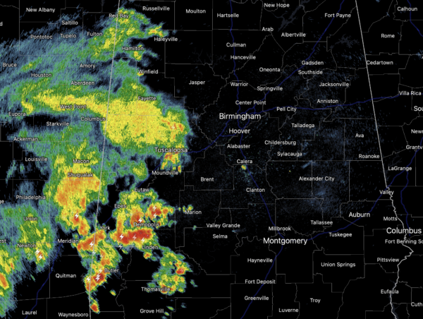
Approaching the midday hours, a look at the radar shows widespread showers and storms across West Central Alabama, and these will continue to slide east through the afternoon, allowing for a rather wet afternoon for many locations. Of course some strong storms are possible with gusty winds and lots of lightning, but also torrential tropical downpours could lead to areas of isolated flash flooding, which we have see several times this summer.
REST OF THE WEEK: The front pushes farther south this week, and showers and storms for tomorrow will be confined to the southern third of Alabama. For North/Central Alabama, the sky will be partly to mostly sunny with a high in the mid to upper 80s, and any shower activity for the this part of the state will be few and far between. Wednesday through Friday, we expect partly sunny days with just few widely scattered showers and storms. Mainly during the afternoon and evening hours. Highs these days will be generally in the upper 80s, which are a few degrees below average for early August in Alabama.
BEACH FORECAST CENTER: Get the latest weather and rip current forecasts for the beaches from Fort Morgan to Panama City on our Beach Forecast Center page. There, you can select the forecast of the region that you are interested in visiting.
WORLD TEMPERATURE EXTREMES: Over the last 24 hours, the highest observation outside the U.S. was 121.8F at Jahra, Kuwait. The lowest observation was -93.3F at Dome A, Antarctica.
CONTIGUOUS TEMPERATURE EXTREMES: Over the last 24 hours, the highest observation was 115F at Death Valley, CA. The lowest observation was 34F at Berthoud Pass, CO.
WEATHER ON THIS DATE IN 1975: Record heat gripped New England. Highs of 104 degrees at Providence, RI, and 107 degrees at Chester and New Bedford, MA, established state records. The heat along the coast of Maine was unprecedented, with afternoon highs of 101 degrees at Bar Harbor and 104 degrees at Jonesboro.
Category: Alabama's Weather, ALL POSTS
About the Author (Author Profile)
Macon, Georgia Television Chief Meteorologist, Birmingham native, and long time Contributor on AlabamaWX. Stormchaser. I did not choose Weather, it chose Me. College Football Fanatic. @Ryan_StinnetSubscribe
If you enjoyed this article, subscribe to receive more just like it.


