

Midday Nowcast: Plenty of Sun
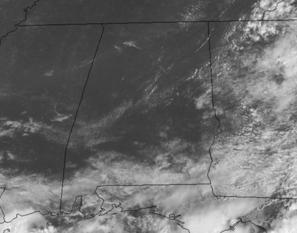
The frontal boundary continues to slowly sink south through the state and is across South Alabama this afternoon. This boundary will be the focal point for showers and storms across South Alabama, while across the northern half of the state, drier air is settling into the area. Any showers will be few and far between as we are seeing more sun than clouds with highs generally in the mid-80s.
REST OF THE WEEK: For North/Central Alabama, the sky will be partly to mostly sunny with highs in the mid to upper 80s, and any shower activity for the this part of the state will be very isolated in nature as rain chances are generally around the 20% range.
THE ALABAMA WEEKEND: Pretty routine weather for the weekend as both Saturday and Sunday will feature a mix of sun and clouds. Rain chances do look to increase some over the weekend, but no weekend “wash out” by any means. For now we are forecasting scattered to perhaps numerous showers and storms, mainly during the afternoon and evening hours. Highs over the weekend will be around 90 degrees.
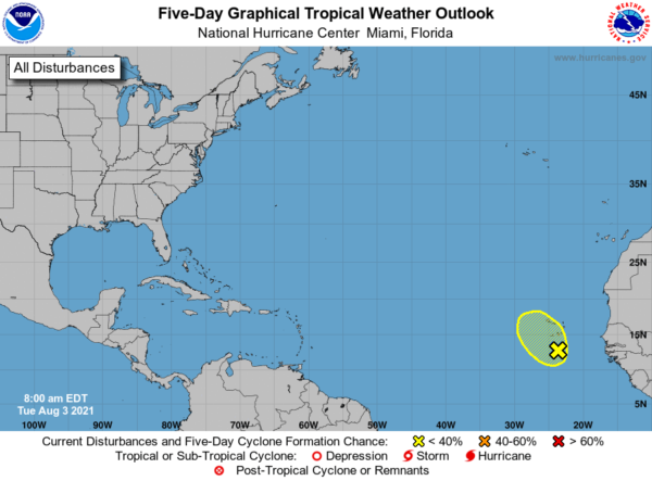
IN THE TROPICS: A small area of low pressure with a few associated showers and thunderstorms has formed about 120 miles south of Praia in the Cabo Verde Islands. Further development of this system, if any, should be limited during the next day or two while it moves northward or northwestward before the system moves over cooler waters by Thursday. Locally heavy rainfall and gusty winds are possible over portions of the Cabo Verde Islands through Wednesday. Formation chance through 5 days…low…10 percent.
BEACH FORECAST CENTER: Get the latest weather and rip current forecasts for the beaches from Fort Morgan to Panama City on our Beach Forecast Center page. There, you can select the forecast of the region that you are interested in visiting.
WORLD TEMPERATURE EXTREMES: Over the last 24 hours, the highest observation outside the U.S. was 121.6F at Jahra, Kuwait. The lowest observation was -92.9F at Dome A, Antarctica.
CONTIGUOUS TEMPERATURE EXTREMES: Over the last 24 hours, the highest observation was 120F at Death Valley, CA. The lowest observation was 35F at Albany, WY.
Category: Alabama's Weather, ALL POSTS
About the Author (Author Profile)
Macon, Georgia Television Chief Meteorologist, Birmingham native, and long time Contributor on AlabamaWX. Stormchaser. I did not choose Weather, it chose Me. College Football Fanatic. @Ryan_StinnetSubscribe
If you enjoyed this article, subscribe to receive more just like it.


