

10 a.m. Advisory: PTC6 Not Yet a Tropical Storm
Here is the latest on Potential Tropical Cyclone Six. It has enough organization on satellite and enough wind reports to be a tropical storm, but it still lacks the well-defined center of a tropical cyclone. So the NHC is still holding it in the PTC stage for now. It is expected to become a tropical storm later today.
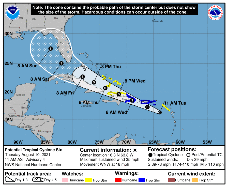
The official track has it entering the Gulf of Mexico Sunday morning and moving north northwest, brushing Tampa Saturday night and heading for a landfall in the Panhandle Sunday afternoon or night.
But the forecast cone of where the center could be by then literally is pointing at anywhere along the coast from New Orleans the Big Bend to Jacksonville and even to Melbourne on the East Coast. It is too early to make decisions about interests along the Alabama and Northwest Florida coast. We have several days to watch it.
All interests around the northern and eastern Gulf of Mexico should pay close attention to later forecasts.
Here is the text of the advisory:
BULLETIN
Potential Tropical Cyclone Six Advisory Number 4
NWS National Hurricane Center Miami FL AL062021
1100 AM AST Tue Aug 10 2021
…NOAA HURRICANE HUNTER AIRCRAFT REPORTS THE DISTURBANCE IS NOT
YET A TROPICAL CYCLONE…
…LIKELY TO BECOME A TROPICAL STORM LATER TODAY OR TONIGHT…
SUMMARY OF 1100 AM AST…1500 UTC…INFORMATION
———————————————–
LOCATION…16.3N 63.8W
ABOUT 160 MI…255 KM W OF GUADELOUPE
ABOUT 220 MI…350 KM ESE OF PONCE PUERTO RICO
MAXIMUM SUSTAINED WINDS…35 MPH…55 KM/H
PRESENT MOVEMENT…WNW OR 295 DEGREES AT 18 MPH…30 KM/H
MINIMUM CENTRAL PRESSURE…1012 MB…29.89 INCHES
WATCHES AND WARNINGS
——————–
CHANGES WITH THIS ADVISORY:
The Government of France has discontinued the Tropical Storm Watch
for Martinique and Guadeloupe.
SUMMARY OF WATCHES AND WARNINGS IN EFFECT:
A Tropical Storm Warning is in effect for…
* Puerto Rico, including Culebra and Vieques
* U.S. Virgin Islands
* Dominican Republic on the south coast from Punta Palenque
eastward and on the north coast from Cabo Frances Viejo eastward
A Tropical Storm Watch is in effect for…
* Saba and St. Eustatius
* Dominican Republic on the north coast from Cabo Frances Viejo to
the Dominican Republic/Haiti border
* Haiti from the northern border with the Dominican Republic to
Gonaives
* Turks and Caicos Islands
* Southeastern Bahamas
A Tropical Storm Warning means that tropical storm conditions are
expected somewhere within the warning area within 36 hours.
A Tropical Storm Watch means that tropical storm conditions are
possible within the watch area.
Interests elsewhere in Haiti and the Bahamas, as well as in eastern
and central Cuba, should monitor the progress of this system.
For storm information specific to your area in the United
States, including possible inland watches and warnings, please
monitor products issued by your local National Weather Service
forecast office. For storm information specific to your area
outside of the United States, please monitor products issued by
your national meteorological service.
DISCUSSION AND OUTLOOK
———————-
At 1100 AM AST (1500 UTC), the disturbance was centered near
latitude 16.3 North, longitude 63.8 West. The system is moving
toward the west-northwest near 18 mph (30 km/h) and this general
motion is expected to continue during the next few days. On the
forecast track, the disturbance is expected to pass near or over
the U.S. Virgin Islands and Puerto Rico later today and tonight,
be near or over Hispaniola on Wednesday, and be near the
southeastern Bahamas and the Turks and Caicos Islands Thursday.
Reports from a NOAA Hurricane Hunter aircraft indicate that maximum
sustained winds are near 35 mph (55 km/h) with higher gusts.
However, the aircraft did not find a well-defined closed
circulation. Gradual strengthening is forecast during the next day
or so and the disturbance is expected to become a tropical storm
later today or tonight. Some weakening is likely while the system
interacts with Hispaniola on Wednesday.
* Formation chance through 48 hours…high…90 percent.
* Formation chance through 5 days…high…90 percent.
The estimated minimum central pressure is 1012 mb (29.89 inches).
HAZARDS AFFECTING LAND
———————-
Key messages for Potential Tropical Cyclone Six can be found in
the Tropical Cyclone Discussion under AWIPS header MIATCDAT1,
WMO header WTNT41 KNHC and on the web at
www.hurricanes.gov/graphics_at1.shtml?key_messages.
RAINFALL: The potential tropical cyclone is expected to produce the
following rainfall amounts:
Over the Leeward Islands, Virgin Islands, and Puerto Rico…2 to 4
inches, with isolated amounts of 6 inches. Heavy rainfall could lead
to flash, urban, and small stream flooding, along with possible
rapid river rises and the potential for mudslides across the U.S.
Virgin Islands and Puerto Rico.
Over the northern Windward Islands…1 to 3 inches.
Over the Dominican Republic…3 to 6 inches.
WIND: Tropical storm conditions are possible within the watch area
in the Lesser Antilles for the next few hours. Tropical storm
conditions are expected in the warning areas in the U.S. Virgin
Islands and Puerto Rico later today, and in the Dominican Republic
by early Wednesday. Tropical storm conditions are possible
elsewhere along the northern coasts of the Dominican Republic,
northern Haiti, the Turks and Caicos, and the southeastern Bahamas
beginning late Wednesday.
SURF: Swells generated by the disturbance are affecting portions of
the Leeward Islands. These swells are expected to spread across the
U.S. Virgin Islands and Puerto Rico today and reach portions of
Hispaniola on Wednesday, where they could cause life-threatening
surf and rip current conditions. Please consult products from your
local weather office.
NEXT ADVISORY
————-
Next intermediate advisory at 200 PM AST.
Next complete advisory at 500 PM AST.
$$
Forecaster Beven
Category: Alabama's Weather, ALL POSTS, Tropical
About the Author (Author Profile)
Bill Murray is the President of The Weather Factory. He is the site's official weather historian and a weekend forecaster. He also anchors the site's severe weather coverage. Bill Murray is the proud holder of National Weather Association Digital Seal #0001 @wxhistorianSubscribe
If you enjoyed this article, subscribe to receive more just like it.


