

4 pm Advisory: System Likely to Become Tropical Storm Fred Tonight
The system is still not a tropical storm despite strong convection and tropical storm force winds. It still lacks a well-defined center. That is probably going to happen in the next few hours though and it will eventually be named Fred.
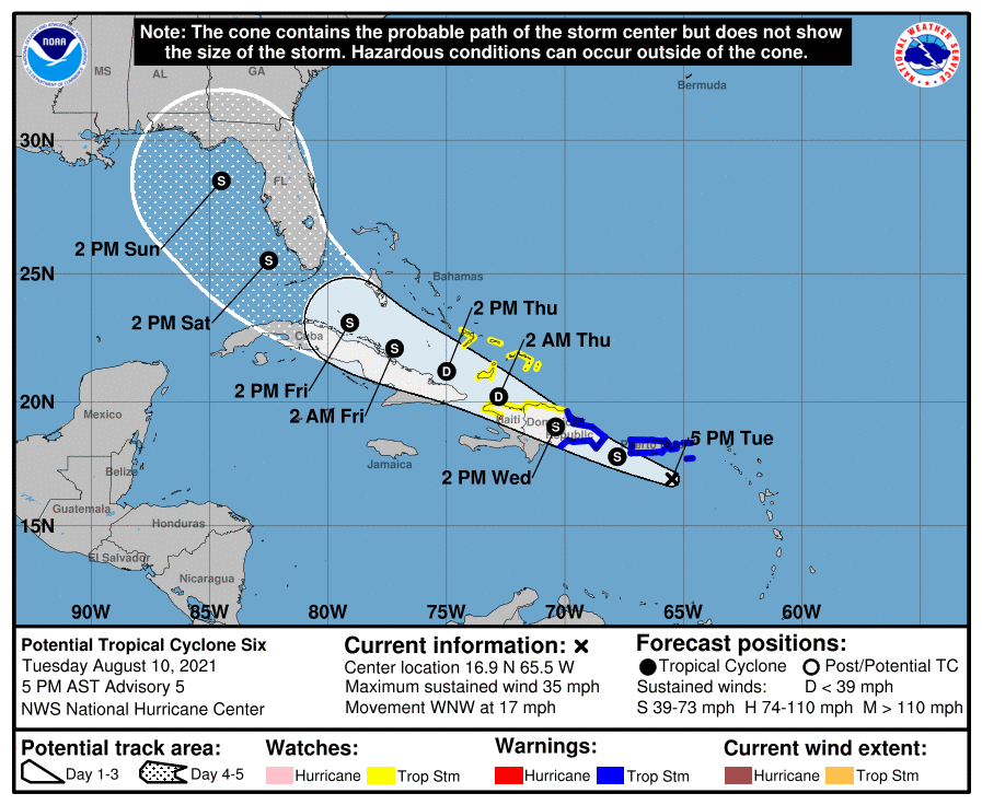
It is supposed to weaken when it crosses Hispaniola starting tomorrow, but it will re-intensify as it moves along the north coast of Cuba by Thursday. It will regain Tropical Storm status by Friday and move into the southeastern Gulf of Mexico Saturday morning.
There is a great deal of uncertainty in the longer range, but the official track takes it to near the coast over the Northeastern Gulf by late Sunday, perhaps near Panama City, moving northwest.
The forecast cone shows the average forecast error out at those forecast periods, showing a range of where the center might be, not the area that will experience impacts. As we get closer to the end of the week, the specific track and impacts will become more clear.
Here’s the full text of the advisory.
BULLETIN
Potential Tropical Cyclone Six Advisory Number 5
NWS National Hurricane Center Miami FL AL062021
500 PM AST Tue Aug 10 2021
…DISTURBANCE NOW SOUTH OF THE VIRGIN ISLANDS…
…SYSTEM LIKELY TO BECOME A TROPICAL STORM TONIGHT…
SUMMARY OF 500 PM AST…2100 UTC…INFORMATION
———————————————-
LOCATION…16.9N 65.5W
ABOUT 105 MI…170 KM SE OF PONCE PUERTO RICO
ABOUT 310 MI…500 KM ESE OF SANTO DOMINGO DOMINICAN REPUBLIC
MAXIMUM SUSTAINED WINDS…35 MPH…55 KM/H
PRESENT MOVEMENT…WNW OR 295 DEGREES AT 17 MPH…28 KM/H
MINIMUM CENTRAL PRESSURE…1012 MB…29.89 INCHES
WATCHES AND WARNINGS
——————–
CHANGES WITH THIS ADVISORY:
None.
SUMMARY OF WATCHES AND WARNINGS IN EFFECT:
A Tropical Storm Warning is in effect for…
* Puerto Rico, including Culebra and Vieques
* U.S. Virgin Islands
* Dominican Republic on the south coast from Punta Palenque
eastward and on the north coast from Cabo Frances Viejo eastward
A Tropical Storm Watch is in effect for…
* Dominican Republic on the north coast from Cabo Frances Viejo to
the Dominican Republic/Haiti border
* Haiti from the northern border with the Dominican Republic to
Gonaives
* Turks and Caicos Islands
* Southeastern Bahamas
A Tropical Storm Warning means that tropical storm conditions are
expected somewhere within the warning area within 36 hours.
A Tropical Storm Watch means that tropical storm conditions are
possible within the watch area.
Interests elsewhere in Haiti and the Bahamas, as well as in eastern
and central Cuba, should monitor the progress of this system.
For storm information specific to your area in the United States,
including possible inland watches and warnings, please monitor
products issued by your local National Weather Service forecast
office. For storm information specific to your area outside of the
United States, please monitor products issued by your national
meteorological service.
DISCUSSION AND OUTLOOK
———————-
At 500 PM AST (2100 UTC), the disturbance was centered near latitude
16.9 North, longitude 65.5 West. The system is moving toward the
west-northwest near 17 mph (28 km/h) and this general motion is
expected to continue during the next few days. On the forecast
track, the disturbance is expected to pass near or over the U.S.
Virgin Islands and Puerto Rico tonight, be near or over Hispaniola
on Wednesday, and be near the southeastern Bahamas and the Turks
and Caicos Islands on Thursday.
Maximum sustained winds are near 35 mph (55 km/h) with higher gusts.
Gradual strengthening is forecast during the next day or so and the
disturbance is expected to become a tropical storm tonight. Some
weakening is likely while the system interacts with Hispaniola on
Wednesday.
* Formation chance through 48 hours…high…90 percent.
* Formation chance through 5 days…high…90 percent.
The estimated minimum central pressure is 1012 mb (29.89 inches).
HAZARDS AFFECTING LAND
———————-
Key messages for Potential Tropical Cyclone Six can be found in
the Tropical Cyclone Discussion under AWIPS header MIATCDAT1,
WMO header WTNT41 KNHC and on the web at
www.hurricanes.gov/graphics_at1.shtml?key_messages.
RAINFALL: The system is expected to produce the following rainfall
amounts:
Over the Leeward Islands, Virgin Islands, Puerto Rico, and the
Dominican Republic…2 to 4 inches, with isolated maximum totals of
6 inches. Heavy rainfall could lead to flash, urban, and small
stream flooding, along with possible rapid river rises and the
potential for mudslides across the U.S. Virgin Islands, Puerto Rico,
and the Dominican Republic.
Over Haiti, the Turks and Caicos, eastern Bahamas, and eastern
Cuba…1 to 3 inches with isolated maximum totals of 5 inches.
WIND: Tropical storm conditions are expected in the warning areas
in the U.S. Virgin Islands and Puerto Rico during the next several
hours, and in the warning area in the Dominican Republic by early
Wednesday. Tropical storm conditions are possible elsewhere along
the northern coasts of the Dominican Republic, northern Haiti, the
Turks and Caicos, and the southeastern Bahamas beginning late
Wednesday.
SURF: Swells generated by the disturbance are affecting portions of
the Leeward Islands. These swells are expected to spread across the
U.S. Virgin Islands and Puerto Rico today and reach portions of
Hispaniola on Wednesday, where they could cause life-threatening
surf and rip current conditions. Please consult products from your
local weather office.
NEXT ADVISORY
————-
Next intermediate advisory at 800 PM AST.
Next complete advisory at 1100 PM AST.
$$
Forecaster Beven
NNNN
Category: Alabama's Weather, ALL POSTS, Tropical
About the Author (Author Profile)
Bill Murray is the President of The Weather Factory. He is the site's official weather historian and a weekend forecaster. He also anchors the site's severe weather coverage. Bill Murray is the proud holder of National Weather Association Digital Seal #0001 @wxhistorianSubscribe
If you enjoyed this article, subscribe to receive more just like it.


