

1 pm Advisory — Fred Continues to Drop Heavy Rains Across Parts of Hispaniola
SUMMARY OF 1:00 PM CDT INFORMATION
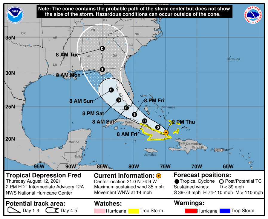
LOCATION…21.0N 74.9W
ABOUT 105 MI…170 KM W OF GREAT INAGUA ISLAND
ABOUT 180 MI…290 KM E OF CAMAGUEY CUBA
MAXIMUM SUSTAINED WINDS…35 MPH…55 KM/H
PRESENT MOVEMENT…WNW OR 300 DEGREES AT 14 MPH…22 KM/H
MINIMUM CENTRAL PRESSURE…1014 MB…29.94 INCHES
WATCHES AND WARNINGS
A Tropical Storm Watch is in effect for…
* Southeastern Bahamas
* The Cuban provinces of Ciego de Avila, Camaguey, Las Tunas, Holguin, Granma, Santiago de Cuba, and Guantanamo
DISCUSSION AND OUTLOOK
At 200 PM EDT (1800 UTC), the center of Tropical Depression Fred was located near latitude 21.0 North, longitude 74.9 West. The depression is moving toward the west-northwest near 14 mph (22 km/h), and this motion with a decrease in forward speed is expected for the next day or two. A turn to the northwest is expected by Saturday. On the forecast track, Fred is expected to move near the southeastern Bahamas today, move along or just north of eastern and central Cuba later today and Friday, and be near the Florida Keys and southern Florida on Saturday.
Maximum sustained winds are near 35 mph (55 km/h) with higher gusts, mainly in squalls to the northeast of the center. Little change in strength is expected through tonight. Slow strengthening is expected Friday through Saturday, and Fred is forecast to regain tropical-storm strength during that time.
The minimum central pressure estimated from Air Force Reserve Hurricane Hunter data and surface observations is 1014 mb (29.94 inches).
HAZARDS AFFECTING LAND
RAINFALL: Fred is expected to produce the following rainfall amounts:
Across the Dominican Republic and Haiti…3 to 5 inches, with isolated maximum totals of 8 inches. Heavy rainfall through today could lead to flash, urban, and small stream flooding, along with possible rapid river rises and the potential for mudslides.
Over the Turks and Caicos, Cuba and the eastern Bahamas…1 to 3 inches with isolated maximum totals of 5 inches.
Across the western Bahamas…3 to 5 inches, with isolated maximum totals of 8 inches.
From Friday into early next week, heavy rainfall associated with Fred will impact Florida and parts of the Southeast. Through Monday, 3 to 5 inches of rain is anticipated across the Keys and southern Florida Peninsula, with isolated maximum totals of 8 inches. Heavy rainfall could lead to areal, urban, and small stream flooding, along with possible rapid river rises.
WIND: Tropical storm conditions, mainly in brief squalls, are possible in the southeastern Bahamas this afternoon. Tropical storm conditions are possible in the watch area in Cuba beginning this afternoon.
SURF: Swells generated by Fred are expected to spread across portions of the Bahamas and northern coast of Cuba during the next couple of days. These swells could reach the Florida Keys and southern Florida by early Saturday. Please consult products from your local weather office for more details.
About the Author (Author Profile)
Scott Martin is an operational meteorologist, professional graphic artist, musician, husband, and father. Not only is Scott a member of the National Weather Association, but he is also the Central Alabama Chapter of the NWA president. Scott is also the co-founder of Racecast Weather, which provides forecasts for many racing series across the USA. He also supplies forecasts for the BassMaster Elite Series events including the BassMaster Classic.Subscribe
If you enjoyed this article, subscribe to receive more just like it.


