

10 pm Advisory — Grace Forecast to be a Tropical Storm on Tuesday

SUMMARY OF 10 PM CDT INFORMATION
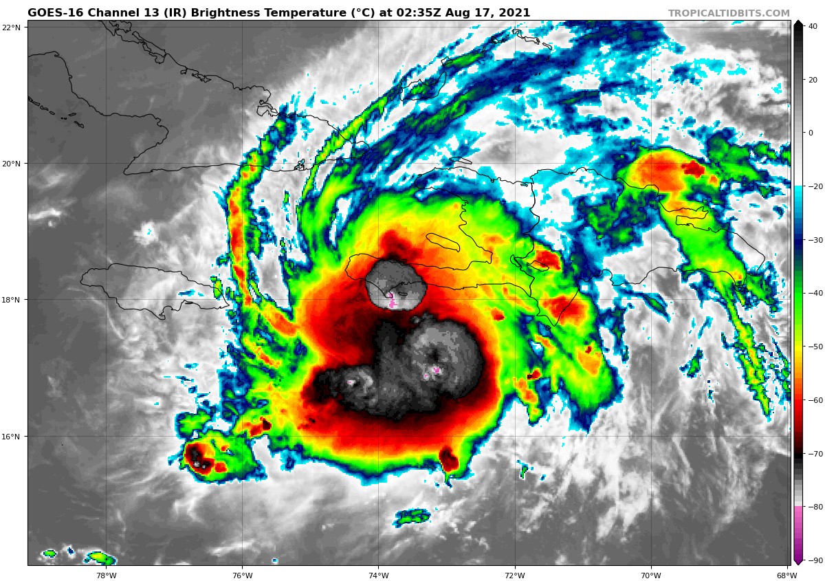
LOCATION…18.2N 73.8W
ABOUT 100 MI…165 KM WSW OF PORT AU PRINCE, HAITI
ABOUT 270 MI…435 KM E OF MONTEGO BAY, JAMAICA
MAXIMUM SUSTAINED WINDS…35 MPH…55 KM/H
PRESENT MOVEMENT…W OR 280 DEGREES AT 14 MPH…22 KM/H
MINIMUM CENTRAL PRESSURE…1006 MB…29.71 INCHES
WATCHES AND WARNINGS
A Tropical Storm Warning is in effect for…
* Southern coast of the Cuban provinces of Santiago de Cuba, Granma, Las Tunas, and Camaguey
* Cayman Islands
A Tropical Storm Watch is in effect for…
* Entire coast of Haiti
* Jamaica
* Southern coast of the Cuban provinces of Ciego de Avila, Sancti Spiritus, Cienfuegos, Matanzas, and Pinar del Rio, as well as Isla de la Juventud.
FORECAST DISCUSSION
IR and microwave imagery during the past few hours indicate that Grace’s convective organization has improved a little since this afternoon. However, it is currently unknown if that has translated to a better-defined surface wind field. Dvorak intensity estimates from TAFB and SAB at 00Z supported tropical storm strength, and it is possible Grace has redeveloped sustained winds of that magnitude. A hurricane hunter aircraft is scheduled to investigate Grace in a few hours, so it seems prudent to avoid making a big change before the plane gets there. Grace is therefore conservatively maintained as a 30 kt depression for this advisory. Regardless of Grace’s exact intensity right now, the immediate threat is still torrential rainfall across Hispaniola overnight, which will likely cause severe flooding in some locations.
The initial motion estimate is 280/12 kt. Confidence in the track forecast has increased considerably during the past 24 h and the track model spread is low. A mid-level ridge is forecast to build over the Gulf of Mexico during the next several days, which should keep Grace on a generally westward or west-northwestward track through day 5. Once Grace moves away from Haiti, it should remain over water until it reaches the Yucatán peninsula late Wednesday or early Thursday. Very little change was made to the official track forecast, which is based primarily on the multi-model consensus TVCN.
Now that Grace is forecast to avoid all major land masses for the next couple of days, all of the intensity guidance calls for some strengthening to occur. That said, with the exception of the COAMPS-TC model, the intensity guidance as a whole shows a slower rate of strengthening than it did 6 h ago. The NHC forecast is now very near the IVCN intensity consensus throughout the forecast, including over the Gulf of Mexico, where it continues to show Grace reaching hurricane strength. Despite the slightly lower guidance for this forecast, it still can not be ruled out that Grace will reach hurricane strength over the western Caribbean. When the hurricane hunter aircraft reaches Grace in a couple hours and provides more information about the current organization of the cyclone, we should have a better feel for how quickly it could intensify prior to reaching the coast of Mexico.
KEY MESSAGES
1. Heavy rainfall across the Dominican Republic, Haiti, Cuba, Jamaica, the Cayman Islands, and the northern Yucatán Peninsula may lead to flash, urban, and small stream flooding, with the potential for mudslides highest in Haiti and the Dominican Republic.
2. Tropical storm conditions are possible over portions of Hispaniola overnight, and over Jamaica on Tuesday. Tropical storm conditions are expected over portions of the southern coast of Cuba on Tuesday, spreading westward to the Cayman Islands and possibly other portions of the southern coast of Cuba Tuesday evening through Wednesday morning.
3. There is an increasing risk of wind, rainfall, and storm surge impacts on the Yucatán Peninsula of Mexico Wednesday night and Thursday. Interests there areas should monitor the progress of Grace and updates to the forecast.
About the Author (Author Profile)
Scott Martin is an operational meteorologist, professional graphic artist, musician, husband, and father. Not only is Scott a member of the National Weather Association, but he is also the Central Alabama Chapter of the NWA president. Scott is also the co-founder of Racecast Weather, which provides forecasts for many racing series across the USA. He also supplies forecasts for the BassMaster Elite Series events including the BassMaster Classic.Subscribe
If you enjoyed this article, subscribe to receive more just like it.


