

7 pm Advisory — Hurricane Grace Forecast to Bring Strong Winds & Dangerous Storm Surge to the Eastern Yucatan Peninsula
SUMMARY OF 7 PM CDT INFORMATION
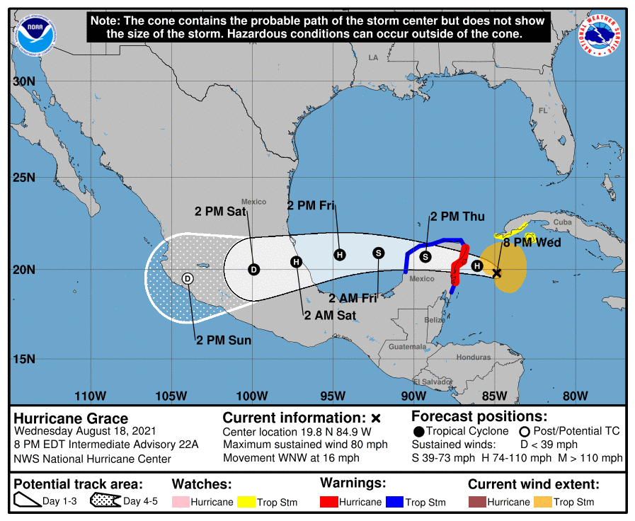
LOCATION…19.8N 84.9W
ABOUT 170 MI…275 KM E OF TULUM, MEXICO
MAXIMUM SUSTAINED WINDS…80 MPH…130 KM/H
PRESENT MOVEMENT…WNW OR 285 DEGREES AT 16 MPH…26 KM/H
MINIMUM CENTRAL PRESSURE…989 MB…29.20 INCHES
WATCHES AND WARNINGS
A Hurricane Warning is in effect for…
* Yucatán Peninsula of Mexico from Cancun to Punta Herrero, including Cozumel
A Tropical Storm Warning is in effect for…
* Yucatán Peninsula of Mexico from north of Cancun to Campeche
* Yucatán Peninsula of Mexico from south of Punta Herrero to Puerto Costa Maya
A Tropical Storm Watch is in effect for…
* Southern coast Cuban province of Pinar del Rio, as well as Isla de la Juventud
FORECAST DISCUSSION
At 800 PM EDT (0000 UTC), the center of Hurricane Grace was located near latitude 19.8 North, longitude 84.9 West. Grace is moving toward the west-northwest near 16 mph (26 km/h). A general west-northwestward to westward motion is expected for the next several days. On the forecast track, Grace is expected to make landfall in the eastern Yucatán Peninsula Thursday morning, move over the Yucatán Peninsula on Thursday, and move over the southwest Gulf of Mexico Thursday night or early Friday.
Maximum sustained winds are near 80 mph (130 km/h) with higher gusts. Some strengthening is possible before the center of Grace reaches the Yucatán Peninsula. Weakening will occur while the center moves over the Yucatán Peninsula on Thursday, with restrengthening expected when Grace moves over the southwest Gulf of Mexico on Friday.
Hurricane-force winds extend outward up to 15 miles (30 km) from the center, and tropical-storm-force winds extend outward up to 140 miles (220 km). NOAA buoy 40256, located west of the center, recently reported sustained winds of 45 mph (72 km/h) and a wind gust of 51 mph (83 km/h).
The minimum central pressure estimated from Air Force Reserve and NOAA Hurricane Hunter aircraft data is 989 mb (29.32 inches).
HAZARDS TO LAND
WIND: Strong, gusty winds are likely over portions of the Cayman Islands for the next few hours. Tropical storm conditions are possible along the southern coast of Cuba within the watch area for the next several hours. Hurricane conditions are expected within the warning area in the Yucatán Peninsula of Mexico late tonight or early Thursday, with tropical storm conditions beginning as early as this evening.
RAINFALL: The system is expected to produce the following rainfall amounts:
Over the Cayman Islands and central to northern portions of the Yucatán Peninsula, 4 to 8 inches of rain, with isolated maximum totals of 12 inches, are expected through Friday. Heavy rainfall from Grace will likely result in areas of flash and urban flooding.
Over the central to northern Veracruz state of Mexico, 5 to 10 inches of rain, with isolated maximum totals of 15 inches, are expected from Friday through Sunday. Heavy rainfall from Grace will likely result in areas of flash and urban flooding, and will also be capable of producing mudslides.
STORM SURGE: A dangerous storm surge will raise water levels by as much as 3 to 5 ft above normal tide levels along the immediate coast near and to the north of where the center makes landfall in the northeastern Yucatán Peninsula late tonight or early Thursday. Near the coast, the surge will be accompanied by large and destructive waves.
SURF: Swells generated by Grace will spread westward from Jamaica and the Cayman Islands to the southern coast of Cuba and the Yucatán Peninsula of Mexico through Thursday. These swells are likely to cause life-threatening surf and rip current conditions. Please consult products from your local weather office.
Category: ALL POSTS, Severe Weather, Tropical
About the Author (Author Profile)
Scott Martin is an operational meteorologist, professional graphic artist, musician, husband, and father. Not only is Scott a member of the National Weather Association, but he is also the Central Alabama Chapter of the NWA president. Scott is also the co-founder of Racecast Weather, which provides forecasts for many racing series across the USA. He also supplies forecasts for the BassMaster Elite Series events including the BassMaster Classic.Subscribe
If you enjoyed this article, subscribe to receive more just like it.


