

10 am Advisory — Henri is Now a Category 1 Hurricane

SUMMARY OF 1000 AM CDT…1500 UTC…INFORMATION
———————————————–
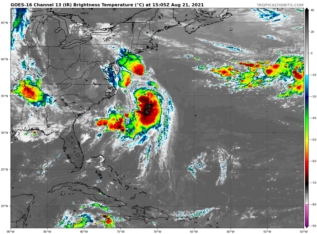
LOCATION…34.4N 72.5W
ABOUT 180 MI…290 KM ESE OF CAPE HATTERAS NORTH CAROLINA
ABOUT 465 MI…745 KM S OF MONTAUK POINT NEW YORK
MAXIMUM SUSTAINED WINDS…75 MPH…120 KM/H
PRESENT MOVEMENT…NNE OR 20 DEGREES AT 14 MPH…22 KM/H
MINIMUM CENTRAL PRESSURE…991 MB…29.27 INCHES
WATCHES AND WARNINGS
——————–
A Storm Surge Warning is in effect for…
* South shore of Long Island from Mastic Beach to Montauk Point New York
* North shore of Long Island from Montauk Point to Flushing New York
* Flushing New York to Chatham Massachusetts
* Nantucket, Martha’s Vineyard, and Block Island
A Storm Surge Watch is in effect for…
* East Rockaway Inlet to Mastic New York
* North of Chatham Massachusetts to Sagamore Beach Massachusetts
* Cape Cod Bay
A Hurricane Warning is in effect for…
* South shore of Long Island from Fire Island Inlet to Montauk Point
* North shore of Long Island from Port Jefferson Harbor to Montauk Point
* New Haven Connecticut to west of Westport Massachusetts
* Block Island
A Tropical Storm Warning is in effect for…
* Port Jefferson Harbor to west of New Haven Connecticut
* South shore of Long Island from west of Fire Island Inlet to East Rockaway Inlet
* Westport Massachusetts to Chatham Massachusetts, including Martha’s Vineyard and Nantucket
* Coastal New York and New Jersey west of East Rockaway Inlet to Manasquan Inlet, including New York City
FORECAST DISCUSSION
——————–
The Air Force Reserve and NOAA Hurricane Hunters have been investigating Henri this morning and continue to provide very valuable data. The Air Force aircraft measured a peak flight-level wind of 82 kt at 700 mb, which easily supports hurricane strength, but the initial intensity is set at 65 kt as a blend of these data and somewhat lower SFMR winds. In addition, aircraft data indicate that the minimum pressure has fallen to 991 mb. The NOAA tail Doppler radar data indicate that the storm is becoming more vertically aligned and that a more symmetric eyewall appears to be forming. In addition, dropsonde data from the NOAA Gulfstream IV aircraft flying around Henri indicate that the 34- and 50-kt wind radii are a little larger than previously estimated in the southeastern quadrant. NOAA buoy 41001 located in the northeastern quadrant of the hurricane has recently reported 18 ft. seas.
Henri is moving north-northeastward, or 020 degrees, at 12 kt. The steering pattern appears fairly well established now with a cut off low located over the central Appalachians and a ridge building to the east and northeast of Henri. This pattern should cause the storm to accelerate to the north or north-northeast today followed by a slight bend to the left on Sunday. The latest run of the GFS has shifted to the east, but overall the models are focused in on landfall being between central Long Island and Rhode Island on Sunday. However, users are reminded to not focus on the center itself, as impacts will extend well away from the center, especially to the east. The new NHC track forecast is a little to the east of the previous one and very near the best-performing models, the consensus aids.
The environment looks favorable for Henri to continue to gain strength through tonight with low shear, upper-level divergence associated with the upper-level trough, and warm SSTs. In fact, the GFS and HWRF models show the minimum pressure dropping by 15 mb or more during that time period. By early Sunday, Henri is predicted to cross the north wall of the Gulf Stream and that should cause some weakening, but Henri is forecast to be at or near hurricane strength at landfall. Once the center moves inland over the northeast United States, rapid weakening is expected. Henri is forecast to become post-tropical in 48-60 hours and dissipate in 3 to 4 days.
KEY MESSAGES
——————–
1. Dangerous storm surge inundation is expected to begin late tonight or Sunday in portions of Long Island, Connecticut, Rhode Island, and southeastern Massachusetts, where a Storm Surge Warning has been issued. Dangerous storm surge is possible beginning late tonight or Sunday in western portions of Long Island and Connecticut in the Storm Surge Watch area. Residents in these areas should follow any advice given by local officials.
2. Hurricane conditions are expected to begin late tonight or Sunday in portions of Long Island, Connecticut, and Rhode Island, where a Hurricane Warning is in effect. Tropical storm conditions will begin in these areas tonight.
3. Heavy rainfall may lead to considerable flash, urban, and small stream flooding, along with the potential for widespread minor and isolated moderate river flooding, over portions of Long Island, New England, southeast New York and northern New Jersey.
4. Swells from Henri will continue to affect much of the east coast of the U.S. during the next day or two. These swells could cause life-threatening surf and rip currents.
Category: ALL POSTS, Severe Weather, Tropical
About the Author (Author Profile)
Scott Martin is an operational meteorologist, professional graphic artist, musician, husband, and father. Not only is Scott a member of the National Weather Association, but he is also the Central Alabama Chapter of the NWA president. Scott is also the co-founder of Racecast Weather, which provides forecasts for many racing series across the USA. He also supplies forecasts for the BassMaster Elite Series events including the BassMaster Classic.Subscribe
If you enjoyed this article, subscribe to receive more just like it.


