

EXPIRED — Severe Tstorm Warning for Shelby County
Severe Thunderstorm Warning
National Weather Service Birmingham AL
559 PM CDT Wed Aug 25 2021
The National Weather Service in Birmingham has issued a
* Severe Thunderstorm Warning for…
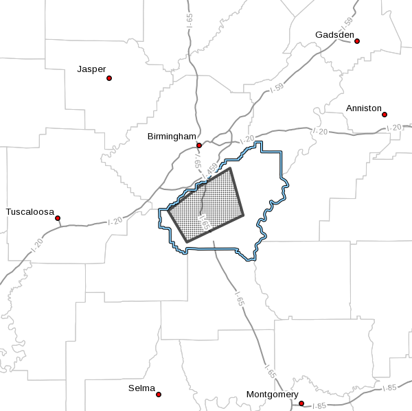
Central Shelby County in central Alabama…
* Until 630 PM CDT.
* At 559 PM CDT, severe thunderstorms were located along a line
extending from Oak Mountain Amphitheater to near Chelsea to near
Columbiana, moving southwest at 25 mph.
HAZARD…60 mph wind gusts and penny size hail.
SOURCE…Radar indicated.
IMPACT…Expect damage to roofs, siding, and trees.
* Locations impacted include…
Hoover, Alabaster, Pelham, Helena, Calera, Chelsea, Montevallo,
Indian Springs Village, American Village, Oak Mountain State Park,
Maylene, Oak Mountain Amphitheater, Highland Lakes, Riverchase,
Shelby County Airport, Meadowbrook, Joe Tucker Park, Camp Branch,
Hoover Veterans Park and Siluria.
PRECAUTIONARY/PREPAREDNESS ACTIONS…
For your protection move to an interior room on the lowest floor of a
building.
To report severe weather, contact your nearest law enforcement
agency. They will send your report to the National Weather Service
office in Birmingham.
Category: Alabama's Weather, ALL POSTS, Severe Weather
About the Author (Author Profile)
Scott Martin is an operational meteorologist, professional graphic artist, musician, husband, and father. Not only is Scott a member of the National Weather Association, but he is also the Central Alabama Chapter of the NWA president. Scott is also the co-founder of Racecast Weather, which provides forecasts for many racing series across the USA. He also supplies forecasts for the BassMaster Elite Series events including the BassMaster Classic.Subscribe
If you enjoyed this article, subscribe to receive more just like it.


