

10 pm Advisory — Hurricane Watches Issued for Portions of the Northern Gulf Coast Ahead of Ida
SUMMARY OF 10 PM CDT INFORMATION
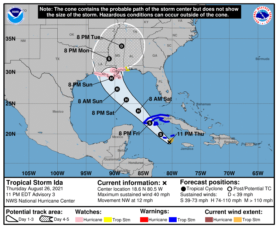
LOCATION…18.6N 80.5W
ABOUT 65 MI…105 KM SE OF GRAND CAYMAN
ABOUT 365 MI…585 KM SE OF THE WESTERN TIP OF CUBA
MAXIMUM SUSTAINED WINDS…40 MPH…65 KM/H
PRESENT MOVEMENT…NW OR 320 DEGREES AT 12 MPH…19 KM/H
MINIMUM CENTRAL PRESSURE…1006 MB…29.71 INCHES
WATCHES AND WARNINGS
A Storm Surge Watch is in effect for…
* Sabine Pass to Alabama/Florida border
* Vermilion Bay, Lake Borgne, Lake Pontchartrain, Lake Maurepas, and Mobile Bay
A Hurricane Watch is in effect for…
* Cameron, Louisiana to the Mississippi/Alabama border
* Lake Pontchartrain, Lake Maurepas, and Metropolitan New Orleans
A Tropical Storm Warning is in effect for…
* Cayman Islands
* Cuban provinces of Matanzas, Mayabeque, Havana, Artemisa, Pinar del Rio, and the Isle of Youth
A Tropical Storm Watch is in effect for…
* Mississippi/Alabama border to the Alabama/Florida border.
FORECAST DISCUSSION
The Air Force Hurricane Hunters have been investigating Ida this evening and found maximum flight-level winds of 47 kt at 2500 ft. This data along with numerous unflagged 35-kt SFMR winds supported raising the intensity to 35 kt earlier this evening. Since the aircraft departed Ida, there has been generally little change in the storm’s structure, so the initial intensity is held at 35 kt. Ida is an asymmetric tropical storm, with most of the deep convection and stronger winds confined to the eastern half of the circulation. Both the NOAA and Air Force Hurricane Hunters will be investigating Ida Friday morning.
The storm has been wobbling around, but smoothing through the recent erratic motion yields an initial motion estimate of 320/10 kt. A mid-level ridge centered off the southeast U.S. coast is expected to shift westward on Friday and over the weekend. This feature should keep Ida moving in a general northwestward motion for the next 2 or 3 days, taking the core of the system over western Cuba Friday afternoon or evening and then across the southern and central Gulf of Mexico this weekend. Although there is some timing differences in the models, they are in fairly good agreement that Ida will make landfall in Louisiana late Sunday or early Monday. The GFS and ECMWF ensemble members basically span a similar region and are most concentrated across the state of Louisiana. Users are reminded to not focus on the exact forecast track as impacts will extend far from the center and the average 72-hour track error is around 120 miles.
There is some southwesterly vertical wind shear affecting Ida at the moment, which is the likely part of the reason the cloud pattern and wind field are asymmetric. However, the global model show the upper-level pattern becoming quite favorable late Friday and through the weekend. These more conducive winds aloft combined with very warm SSTs and abundant moisture is likely to result in steady or rapid intensification until Ida makes landfall in the U.S. The intensity guidance unanimously show Ida becoming a hurricane, but there is notable spread in how strong the system will become. Given the expected favorable environmental conditions for the storm, the NHC intensity forecast lies near the high end of the model guidance, in the best agreement with the regional hurricane models. It is also worth noting that even though the global models are not particularly accurate in predicting tropical cyclone winds, the GFS and ECMWF show the minimum pressure falling more than 35 mb from the current conditions. Based on all of this information, there is higher-than-normal confidence that a significant hurricane will be approaching the Gulf coast late in the weekend.
KEY MESSAGES
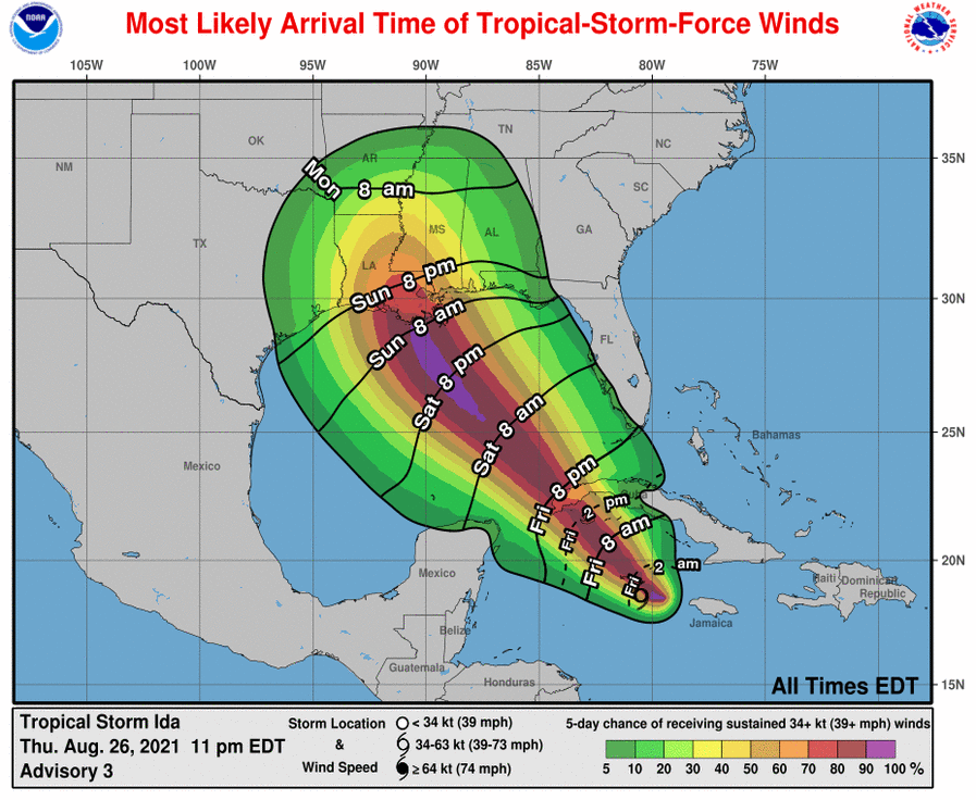
1. Tropical storm conditions are expected in portions of the Cayman Islands tonight and in portions of western Cuba and the Isle of Youth Friday, where a dangerous storm surge is also possible in areas of onshore flow. Life-threatening heavy rains, flash flooding and mudslides are expected across Jamaica, the Cayman Islands, and western Cuba, including the Isle of Youth.
2. There is an increasing risk of life-threatening storm surge inundation along the coasts of Louisiana, Mississippi, and Alabama, where a Storm Surge Watch is in effect. Interests in these areas should follow any advice given by local officials.
3. There is an increasing risk of dangerous hurricane-force winds beginning Sunday along the portions of the coasts of Louisiana and Mississippi, including metropolitan New Orleans, where a Hurricane Watch is in effect.
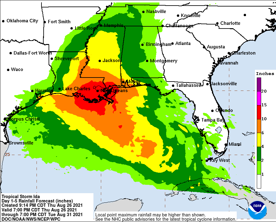
4. Ida is likely to produce heavy rainfall Sunday into Monday along the central Gulf coast, resulting in flash, urban, small stream, and riverine flooding. Heavy rainfall and flooding impacts are likely along the central Gulf Coast Sunday into Monday.
All images, forecasts, and documents are courtesy of their respective publishers.
Category: Alabama's Weather, ALL POSTS, Severe Weather, Tropical
About the Author (Author Profile)
Scott Martin is an operational meteorologist, professional graphic artist, musician, husband, and father. Not only is Scott a member of the National Weather Association, but he is also the Central Alabama Chapter of the NWA president. Scott is also the co-founder of Racecast Weather, which provides forecasts for many racing series across the USA. He also supplies forecasts for the BassMaster Elite Series events including the BassMaster Classic.Subscribe
If you enjoyed this article, subscribe to receive more just like it.


