

Hurricane Ida 7 a.m. Advisory: Preparations Along the Gulf Coast Should be Rushed to Completion
BULLETIN
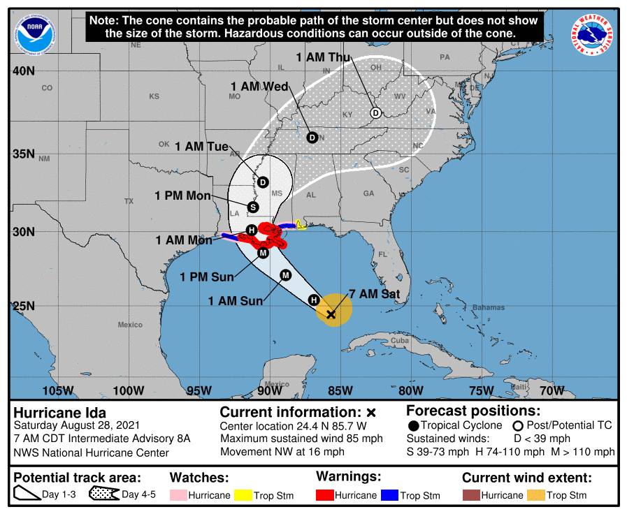
Hurricane Ida Intermediate Advisory Number 8A
NWS National Hurricane Center Miami FL AL092021
700 AM CDT Sat Aug 28 2021
…IDA EXPECTED TO RAPIDLY INTENSIFY AS IT MOVES OVER THE
SOUTHEASTERN AND CENTRAL GULF OF MEXICO THROUGH TONIGHT…
…PREPARATIONS TO PROTECT LIFE AND PROPERTY SHOULD BE RUSHED TO
COMPLETION TODAY IN THE WARNING AREA ALONG THE NORTHERN GULF
COAST…
SUMMARY OF 700 AM CDT…1200 UTC…INFORMATION
———————————————-
LOCATION…24.4N 85.7W
ABOUT 385 MI…620 KM SSE OF THE MOUTH OF THE MISSISSIPPI RIVER
ABOUT 440 MI…710 KM SSE OF NEW ORLEANS LOUISIANA
MAXIMUM SUSTAINED WINDS…85 MPH…140 KM/H
PRESENT MOVEMENT…NW OR 315 DEGREES AT 16 MPH…26 KM/H
MINIMUM CENTRAL PRESSURE…985 MB…29.09 INCHES
WATCHES AND WARNINGS
——————–
CHANGES WITH THIS ADVISORY:
None
SUMMARY OF WATCHES AND WARNINGS IN EFFECT:
A Storm Surge Warning is in effect for…
* East of Rockefeller Wildlife Refuge Louisiana to the
Mississippi/Alabama border
* Vermilion Bay, Lake Borgne, Lake Pontchartrain, and Lake Maurepas
A Hurricane Warning is in effect for…
* Intracoastal City Louisiana to the Mouth of the Pearl River
* Lake Pontchartrain, Lake Maurepas, and Metropolitan New Orleans
A Storm Surge Watch is in effect for…
* Sabine Pass to Rockefeller Wildlife Refuge Louisiana
* Mobile Bay
A Hurricane Watch is in effect for…
* Cameron Louisiana to west of Intracoastal City Louisiana
* Mouth of the Pearl River to the Mississippi/Alabama border
A Tropical Storm Warning is in effect for…
* Cameron Louisiana to west of Intracoastal City Louisiana
* Mouth of the Pearl River to the Mississippi/Alabama border
A Tropical Storm Watch is in effect for…
* Mississippi/Alabama border to the Alabama/Florida border
A Storm Surge Warning means there is a danger of life-threatening
inundation, from rising water moving inland from the coastline,
during the next 36 hours in the indicated locations. For a
depiction of areas at risk, please see the National Weather
Service Storm Surge Watch/Warning Graphic, available at
hurricanes.gov. This is a life-threatening situation. Persons
located within these areas should take all necessary actions to
protect life and property from rising water and the potential for
other dangerous conditions. Promptly follow evacuation and other
instructions from local officials.
A Hurricane Warning means that hurricane conditions are expected
somewhere within the warning area. A warning is typically issued
36 hours before the anticipated first occurrence of
tropical-storm-force winds, conditions that make outside
preparations difficult or dangerous. Preparations to protect life
and property should be rushed to completion.
A Tropical Storm Warning means that tropical storm conditions are
expected somewhere within the warning area within 36 hours.
A Storm Surge Watch means there is a possibility of life-
threatening inundation, from rising water moving inland from the
coastline, in the indicated locations during the next 48 hours.
A Hurricane Watch means that hurricane conditions are possible
within the watch area. A watch is typically issued 48 hours
before the anticipated first occurrence of tropical-storm-force
winds, conditions that make outside preparations difficult or
dangerous.
A Tropical Storm Watch means that tropical storm conditions are
possible within the watch area, generally within 48 hours.
Interests elsewhere along the northern U.S. Gulf coast should
monitor the progress of this system.
For storm information specific to your area, including possible
inland watches and warnings, please monitor products issued by your
local National Weather Service forecast office.
DISCUSSION AND OUTLOOK
———————-
At 700 AM CDT (1200 UTC), the center of Hurricane Ida was located
near latitude 24.4 North, longitude 85.7 West. Ida is moving toward
the northwest near 16 mph (26 km/h) and this general motion should
continue through late Sunday or early Monday, followed by a slower
northward motion on Monday. On the forecast track, the center of
Ida will move over the southeastern Gulf of Mexico today and move
over the central Gulf of Mexico tonight and early Sunday. Ida is
then expected to make landfall along the U.S. northern Gulf coast
within the hurricane warning area on Sunday, and then move inland
over portions of Louisiana or western Mississippi later on Monday.
Maximum sustained winds have increased to near 85 mph (140 km/h)
with higher gusts. Rapid strengthening is forecast during the next
24 to 36 hours and Ida is expected to be an extremely dangerous
major hurricane when it approaches the northern Gulf coast on
Sunday. Weakening is expected after Ida makes landfall.
Hurricane-force winds extend outward up to 25 miles (35 km) from
the center and tropical-storm-force winds extend outward up to 115
miles (185 km).
The latest minimum central pressure estimated from NOAA
reconnaissance aircraft data is 985 mb (29.09 inches).
HAZARDS AFFECTING LAND
———————-
Key messages for Ida can be found in the Tropical Cyclone
Discussion under AWIPS header MIATCDAT4, WMO header WTNT44 KNHC,
and on the web at hurricanes.gov/graphics_at4.shtml?key_messages.
STORM SURGE: The combination of a dangerous storm surge and the
tide will cause normally dry areas near the coast to be flooded by
rising waters moving inland from the shoreline. The water could
reach the following heights above ground somewhere in the indicated
areas if the peak surge occurs at the time of high tide…
Morgan City, LA to Mouth of the Mississippi River…10-15 ft
Mouth of the Mississippi River to Ocean Springs, MS including Lake
Borgne…7-11 ft
Intracoastal City, LA to Morgan City, LA including Vermilion
Bay…6-9 ft
Ocean Springs, MS to MS/AL border…4-7 ft
Lake Pontchartrain…4-7 ft
Lake Maurepas…3-5 ft
Pecan Island, LA to Intracoastal City, LA…3-5 ft
MS/AL border to AL/FL border including Mobile Bay…2-4 ft
Sabine Pass to Pecan Island, LA…2-4 ft
Overtopping of local levees outside of the Hurricane and Storm
Damage Risk Reduction System is possible where local inundation
values may be higher than those shown above.
The deepest water will occur along the immediate coast near and to
the east of the landfall location, where the surge will be
accompanied by large and dangerous waves. Surge-related flooding
depends on the relative timing of the surge and the tidal cycle,
and can vary greatly over short distances. For information
specific to your area, please see products issued by your local
National Weather Service forecast office.
WIND: Hurricane conditions are expected in the hurricane warning
area along the northern Gulf coast beginning Sunday with tropical
storm conditions expected to begin by late Saturday night or early
Sunday morning. These conditions will spread inland over portions
of Louisiana and Mississippi Sunday night and Monday. Gusty winds
are possible over portions of western Cuba and the Florida Keys
this morning.
RAINFALL: Ida will bring an additional 2 to 4 inches of rain
with isolated maximum amounts of 6 inches across western Cuba
today. These rainfall amounts may produce flash floods and
mudslides.
As Ida moves into the Louisiana coast late Sunday, total rainfall
accumulations of 8 to 16 inches with isolated maximum amounts of 20
inches are possible across southeast Louisiana and southern
Mississippi through Monday. This rainfall is likely to result in
significant flash and riverine flooding impacts.
Ida is forecast to turn northeast as it moves inland later Monday,
with rainfall totals of 4 to 8 inches possible from northeastern
Louisiana and central Mississippi into the Tennessee Valley. This is
likely to result in considerable flash and riverine flooding
impacts.
TORNADOES: A few tornadoes will be possible Sunday through early
Monday across southeast Louisiana and southern Mississippi.
SURF: Swells generated by Ida will continue to affect western Cuba
through today. Swells will begin reaching portions of the northern
Gulf coast later today and continue through Monday. These swells
are likely to cause life-threatening surf and rip current
conditions. Please consult products from your local weather office.
NEXT ADVISORY
————-
Next complete advisory at 1000 AM CDT.
$$
Forecaster Brown
Category: Alabama's Weather, ALL POSTS, Headlines, Tropical
About the Author (Author Profile)
Bill Murray is the President of The Weather Factory. He is the site's official weather historian and a weekend forecaster. He also anchors the site's severe weather coverage. Bill Murray is the proud holder of National Weather Association Digital Seal #0001 @wxhistorianSubscribe
If you enjoyed this article, subscribe to receive more just like it.


