

Scattered Showers/Storms Around Through Wednesday
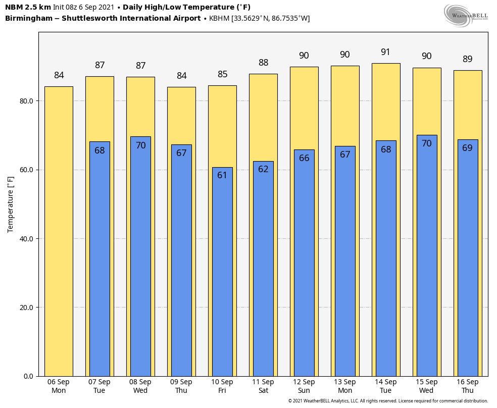
RADAR CHECK: A batch of showers and storms is moving through the Tuscaloosa/Birmingham areas early this morning as I write this just before sunrise. Otherwise, the rest of the state is dry with temperatures mostly in the low to mid 70s. There is a stalled surface front just north of I-59, and it won’t move much through Wednesday, meaning we will have the chance of scattered showers and storms around over the southern 2/3 of the state. No “wash-out”, and the sun will be out at times each day… highs will be in the mid 80s.
The front finally gets a southward push Wednesday night, and a nice surge of dry air rolls into the state Thursday. Look for sunshine in full supply Thursday and Friday, lower humidity levels, and cooler nights. Highs will stay in the mid 80s, but most places will dip into the 50s by Friday morning. It will be our coolest morning so far this season.
THE ALABAMA WEEKEND: Dry weather continues. Expect sunny weather Saturday and Sunday with highs in the upper 80s and lows in the 60s. Humidity values will remain relatively low.
NEXT WEEK: For now it looks like dry weather will continue Monday and Tuesday…then we will introduce the chance of scattered showers and thunderstorms Wednesday through Friday as moisture levels rise. Highs will be around 90 Monday and Tuesday, followed by upper 80s. See the Weather Xtreme video for maps, graphics, and more details.
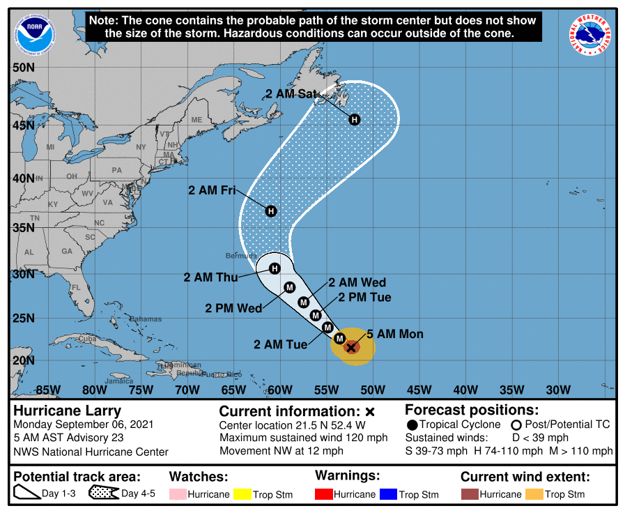
TROPICS: Hurricane Larry is packing winds of 120 mph in the central Atlantic; it will recurve into the open Atlantic well east of the U.S.
And… disorganized showers and thunderstorms over the northern portion of the Yucatan Peninsula and south-central Gulf of Mexico are associated with a surface trough and an upper-level disturbance. The system is forecast to move slowly northward or northeastward over the central and then northeastern Gulf of Mexico, likely reaching the northern Gulf coast in a few days. Although upper-level winds are currently unfavorable for development to occur, they are expected to become marginally conducive for tropical cyclone formation in a couple of days. The disturbance is then expected to cross the southeastern United States beginning midweek, and some development will be possible once it emerges over the Atlantic waters late this week.
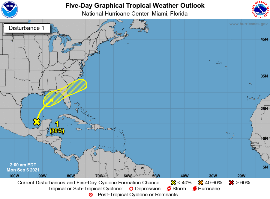
This feature could bring a higher coverage of showers to the central Gulf Coast Wednesday/Thursday, but otherwise no significant impact is expected. The rest of the Atlantic basin is quiet.
ON THIS DATE IN 1881: Forest fires in “The Thumb” of Michigan and Ontario resulted in “Yellow Day” over the New England states. Twenty villages and over a million acres burned in Michigan. The smoke from these fires caused the sky to appear yellow over several New England cities. Twilight appeared at noon on this day.
ON THIS DATE IN 1933: The remnant low of the Treasure Coast Hurricane dumped 10.33″ of rain in Charleston, which is the second-highest 24-hour rainfall total on record for the downtown station. The storm produced wind gusts of 51 mph and also spawned a tornado near the city.
ON THIS DATE IN 2017: Category 5 Hurricane Irma affected the US Virgin Island and Puerto Rico. Maximum sustained winds were at 180 mph when the storm hit St. Thomas and St. John. Catastrophic damage was reported over the US Virgin Island & significant damage over Puerto Rico, especially over Culebra.
BEACH FORECAST: Click here to see the AlabamaWx Beach Forecast Center page.
WEATHER BRAINS: Don’t forget you can listen to our weekly 90 minute show anytime on your favorite podcast app. This is the show all about weather featuring many familiar voices, including our meteorologists here at ABC 33/40.
CONNECT: You can find me on all of the major social networks…
Just one Weather Xtreme video today as we are on a holiday schedule, but I will post fresh forecast notes here on the blog this afternoon. Enjoy the day and Happy Labor Day!
Category: Alabama's Weather, ALL POSTS, Weather Xtreme Videos
About the Author (Author Profile)
James Spann is one of the most recognized and trusted television meteorologists in the industry. He holds the AMS CCM designation and television seals from the AMS and NWA. He is a past winner of the Broadcast Meteorologist of the Year from both professional organizations.Subscribe
If you enjoyed this article, subscribe to receive more just like it.


