

Midday Nowcast: Some Sun and Some Clouds
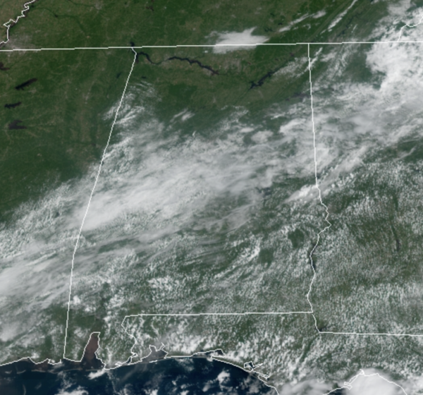
TODAY/TOMORROW: A weak front is stalled across the state and we will maintain scattered showers and storms in the forecast both days, especially for areas along the south of Interstate 59. We are seeing more clouds than sun in many locations, with more sun across areas of the Tennessee Valley; highs this afternoon will be in the mid to upper 80s.
FRONT ON THE WAY: Through the day Thursday, another front will drop into the state from the north, and it will bring a much drier, and cooler air mass into the state setting the stage for another very nice September weekend of weather for Alabama. Friday morning lows will be in the 50 to lower 60s across the state. For Friday, Saturday, and Sunday, expect sunny, dry days and it will remain comfortable. Highs Friday will be in the low 80s, followed by mid to upper 80s Saturday and Sunday, with continued refreshing mornings.
FOOTBALL WEATHER: Expect perfect weather for the high school games across the state Friday night; the sky will be clear with temperatures falling from the upper 70s at kickoff into the upper 60s by the final whistle.
Saturday, Auburn hosts Alabama State at Jordan-hare Stadium (11a CT kickoff)… look for a sunny sky during the game with temperatures rising from near 84 degrees at kickoff to around 87 by the fourth quarter.
Alabama will host Mercer at Bryant-Denny Stadium (3p CT kickoff)… the sky will be sunny with temperatures falling from 88 degrees at kickoff to near 80 degrees by the end of the game.
UAB is on the road; they will take on the Georgia Bulldogs in Athens (2:30p CT kickoff)… the sky will be sunny; about 87 degrees at kickoff, falling to near 81 by the final whistle. And, Jacksonville State is also on the road Saturday night; they take on Florida State in Tallahassee (7p CT kickoff). A brief shower is possible during the first half, otherwise the sky will be mostly fair with temperatures hovering in the 78-82 degree range during the game.
IN THE TROPICS: Disorganized showers and thunderstorms over the south-central Gulf of Mexico are associated with a surface trough and an upper-level disturbance. The system is expected to move slowly northeastward over the central and northeastern Gulf of Mexico during the next couple of days. Upper-level winds are currently unfavorable for development, but they are forecast to become marginally conducive for some limited development as the system nears the northern Gulf coast on Wednesday and Wednesday night. The disturbance is then expected to cross the southeastern United States, and some tropical or subtropical development will be possible after it emerges off the southeastern United States coast late this week. Formation chance through 5 days…low…30 percent.
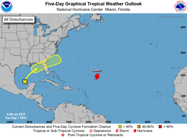
HURRICANE LARRY: The center of Hurricane Larry was located near latitude 24.4 North, longitude 55.6 West. Larry is moving toward the northwest near 9 mph, and this general motion is expected to continue through Wednesday. A turn toward the north-northwest and north with an increase in forward speed is forecast on Thursday. On the forecast track, the center of Larry should pass east of Bermuda on Thursday.

Maximum sustained winds are near 115 mph with higher gusts. Gradual weakening is forecast during the next several days. Larry is a large hurricane. Hurricane-force winds extend outward up to 70 miles from the center and tropical-storm-force winds extend outward up to 185 miles. The minimum central pressure estimated from Air Force Hurricane Hunter observations is 967 mb (28.56 inches).

SURF: Swells generated by Larry will continue to affect the Lesser Antilles, portions of the Greater Antilles, and the Bahamas through midweek, and impact Bermuda through the end of the week. Significant swells should reach the east coast of the United States =and Atlantic Canada by midweek and continue affecting these shores through the end of the week. These swells are likely to cause life-threatening surf and rip current conditions.
BEACH FORECAST CENTER: Get the latest weather and rip current forecasts for the beaches from Fort Morgan to Panama City on our Beach Forecast Center page. There, you can select the forecast of the region that you are interested in visiting.
WORLD TEMPERATURE EXTREMES: Over the last 24 hours, the highest observation outside the U.S. was 118.4F at Jahra, Kuwait. The lowest observation was -97.4F at Concordia, Antarctica.
CONTIGUOUS TEMPERATURE EXTREMES: Over the last 24 hours, the highest observation was 119F at Death Valley, CA. The lowest observation was 19F at Peter Sinks, UT.
WEATHER ON THIS DATE IN 1988: Fifty cities across the eastern U.S. reported record low temperatures for the date. The low of 56 degrees at Mobile AL was their coolest reading of record for so early in the season. The mercury dipped to 31 degrees at Athens OH, and to 30 degrees at Thomas, WV.
Category: Alabama's Weather, ALL POSTS
About the Author (Author Profile)
Macon, Georgia Television Chief Meteorologist, Birmingham native, and long time Contributor on AlabamaWX. Stormchaser. I did not choose Weather, it chose Me. College Football Fanatic. @Ryan_StinnetSubscribe
If you enjoyed this article, subscribe to receive more just like it.


