

Midday Nowcast: Front on the Way
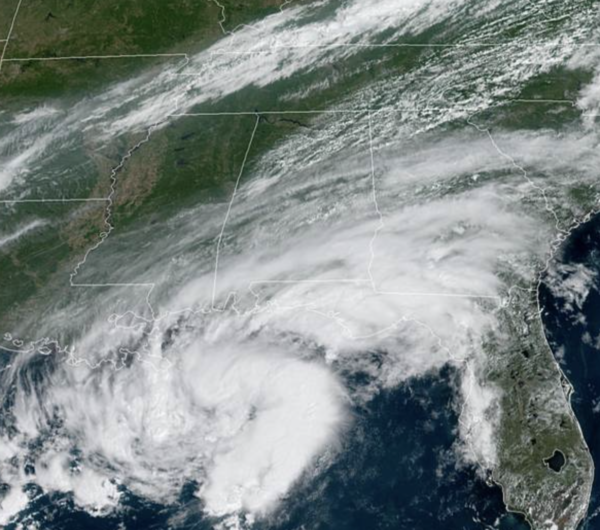
For the northern half of Alabama today, we are seeing a mix of sun and clouds and anticipate some scattered showers and storms ahead of the front, which is approaching the Memphis area just before midday. For the southern half of the state, rain is more widespread due to a tropical feature in the Gulf that is causing quite a bit of of moisture to surge inland. Temperatures this afternoon will be in the mid to upper 80s. A front drops into the state overnight, and will deliver a nice surge of dry air all the way to the Gulf Coast over the next 24 hours.
FEELING LIKE FALL: Tomorrow will feature much lower humidity and a northerly breeze; and through Sunday we are forecasting sunny days, with fair pleasant nights. Highs will be in the low to mid 80s tomorrow and Friday, followed by upper 80s over the weekend. Lows will be mostly in the 60s, but most of North/Central Alabama will enjoy a low in the 50s Friday morning.
FOOTBALL WEATHER: Expect perfect weather for the high school games across the state Friday night; the sky will be clear with temperatures falling from the upper 70s at kickoff into the upper 60s by the final whistle.
Saturday, Auburn hosts Alabama State at Jordan-hare Stadium (11a CT kickoff)… look for a sunny sky during the game with temperatures rising from near 84 degrees at kickoff to around 87 by the fourth quarter.
Alabama will host Mercer at Bryant-Denny Stadium (3p CT kickoff)… the sky will be sunny with temperatures falling from 88 degrees at kickoff to near 80 degrees by the end of the game.
UAB is on the road; they will take on the Georgia Bulldogs in Athens (2:30p CT kickoff)… the sky will be sunny; about 87 degrees at kickoff, falling to near 81 by the final whistle.
Jacksonville State is also on the road Saturday night; they take on Florida State in Tallahassee (7p CT kickoff). A shower is possible during the first half, otherwise the sky will be mostly fair with temperatures hovering in the 78-82 degree range during the game.
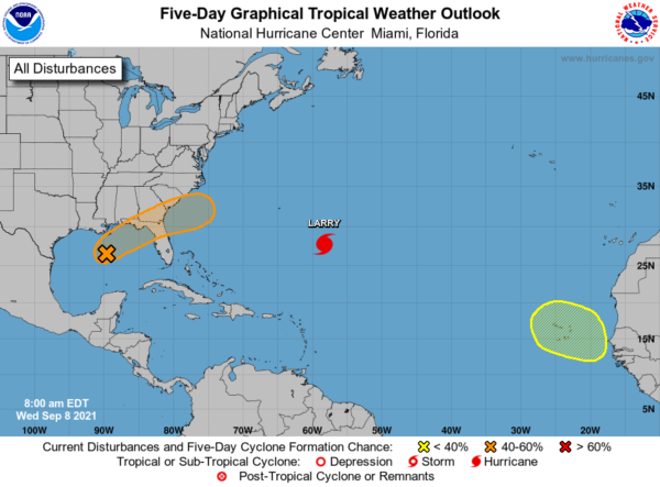
IN THE TROPICS: Disorganized cloudiness and a few thunderstorms over the central and eastern Gulf of Mexico are associated with a surface trough and an upper-level disturbance. The system is expected to move northeastward over the northeastern Gulf of Mexico later today. Upper-level winds could become slightly more favorable to support some tropical or subtropical development as the system nears the northern Gulf coast tonight or early Thursday. The disturbance is then expected to cross the southeastern United States, and some additional development will be possible after it emerges off the southeastern United States coast late this week. Regardless of development, areas of heavy rainfall will be possible across portions of the Florida panhandle and southern Georgia through Thursday, with localized flooding possible. Formation chance through 48 hours…medium…50 percent.
Also, a tropical wave is expected to emerge off of the western coast of Africa in a few days. Some development of this system is possible thereafter as it moves west-northwestward over the far eastern Atlantic. Formation chance through 5 days…low…20 percent.
HURRICANE LARRY: The center of Hurricane Larry was located near latitude 27.7 North, longitude 58.3 West. Larry is moving toward the northwest near 13 mph, and this general motion is expected to continue through today. A turn toward the north-northwest and north with an increase in forward speed is forecast on Thursday, with a faster northeastward motion expected by Friday. On the forecast track, the center of Larry should pass east of Bermuda on Thursday, and move near or over southeastern Newfoundland late Friday.
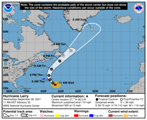
Maximum sustained winds are near 110 mph with higher gusts. Gradual weakening is forecast during the next few days, but Larry is expected to remain a hurricane during that time. Larry is a large hurricane. Hurricane-force winds extend outward up to 70 miles from the center and tropical-storm-force winds extend outward up to 205 miles. The estimated minimum central pressure is 966 mb (28.53 inches).
BEACH FORECAST CENTER: Get the latest weather and rip current forecasts for the beaches from Fort Morgan to Panama City on our Beach Forecast Center page. There, you can select the forecast of the region that you are interested in visiting.
WORLD TEMPERATURE EXTREMES: Over the last 24 hours, the highest observation outside the U.S. was 121.1F at Jahra, Kuwait. The lowest observation was -95.3F at Concordia, Antarctica.
CONTIGUOUS TEMPERATURE EXTREMES: Over the last 24 hours, the highest observation was 122F at Death Valley, CA. The lowest observation was 17F at Peter Sinks, UT.
Category: Alabama's Weather, ALL POSTS
About the Author (Author Profile)
Macon, Georgia Television Chief Meteorologist, Birmingham native, and long time Contributor on AlabamaWX. Stormchaser. I did not choose Weather, it chose Me. College Football Fanatic. @Ryan_StinnetSubscribe
If you enjoyed this article, subscribe to receive more just like it.


