

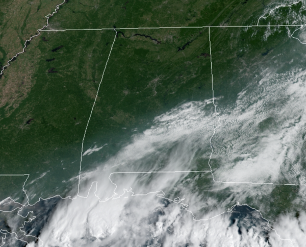
Late Morning Nowcast: Clearing Sky Across Alabama
OH SO NICE!!!: The front pushed through the state overnight and a nice, surge of dry air is settling into the state. The sky is clearing across the state from northwest to southeast, and humidity levels are dropping as dew points fall into the 60s and 50s the next 24 hours.
Temperatures this afternoon are in the low and mid 80s. Tonight, a clear and refreshing night for all of Alabama with lows ranging from the lower 50s to lower 60s.
FRIDAY AND THE WEEKEND: Tomorrow through Sunday, we are forecasting sunny, warm days, with fair pleasant nights. Highs will be in the mid 80s tomorrow, followed by upper 80s Saturday and Sunday. Lows will be mostly in the 60s for most of North/Central Alabama.
FOOTBALL WEATHER: Expect perfect weather for the high school games across the state tomorrow night; the sky will be clear with temperatures falling from the upper 70s at kickoff into the upper 60s by the final whistle.
Saturday, Auburn hosts Alabama State at Jordan-Hare Stadium (11a CT kickoff)… look for a sunny sky during the game with temperatures rising from near 84 degrees at kickoff to around 87 by the fourth quarter.
Alabama will host Mercer at Bryant-Denny Stadium (3p CT kickoff)… the sky will be sunny with temperatures falling from 88 degrees at kickoff to near 80 degrees by the end of the game.
UAB is on the road; they will take on the Georgia Bulldogs in Athens (2:30p CT kickoff)… the sky will be sunny; about 85 degrees at kickoff, falling to near 80 by the final whistle.
And, Jacksonville State is also on the road Saturday night; they take on Florida State in Tallahassee (7p CT kickoff). A passing shower or storm is possible during the first half, otherwise the sky will be mostly fair with temperatures hovering in the 78-82 degree range during the game.
IN THE TROPICS: The National Hurricane Center is issuing advisories on Hurricane Larry, located over the western Atlantic a few hundred miles east-southeast of Bermuda, and on Tropical Depression Mindy, located inland over southeastern Georgia.
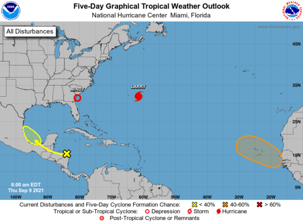
1. The northern portion of a tropical wave over northeastern Honduras and the western Caribbean Sea is forecast to emerge over the southern Bay of Campeche on Saturday. Environmental conditions are expected to be conducive to support some gradual development of the system before it moves over mainland Mexico early next week. Formation chance through 5 days…low…30 percent.
2. A strong tropical wave is expected to emerge off of the west coast of Africa on Saturday. Environmental conditions are forecast to be conducive for development thereafter, and a tropical depression could form by early next week as it moves west-northwestward over the far eastern Atlantic near the Cabo Verde Islands. Formation chance through 5 days…medium…50 percent.
HURRICANE LARRY: The center of Hurricane Larry was located near latitude 32.0 North, longitude 61.6 West. Larry is moving toward the north-northwest near 16 mph, and a turn toward the north with an increase in forward speed is forecast today, with a faster northeastward motion expected by Friday. On the forecast track, the center of Larry will pass east of Bermuda today, and move near or over southeastern Newfoundland Friday night or early Saturday morning.
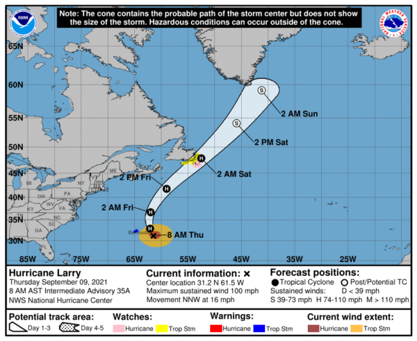
Maximum sustained winds are near 90 mph with higher gusts. Gradual weakening is forecast during the next couple of days, but Larry is expected to remain a hurricane during that time. Larry should become an extratropical cyclone early Saturday, after passing by Newfoundland, then weaken further while it passes southeast of Greenland Sunday night. Larry is expected to be absorbed by a larger extratropical low east of Greenland by Monday. Larry is a large hurricane. Hurricane-force winds extend outward up to 90 miles from the center and tropical-storm-force winds extend outward up to 220 miles. The estimated minimum central pressure is 966 mb (28.53 inches).
TROPICAL DEPRESSION MINDY: The center of Tropical Depression Mindy was located near latitude 31.5 North, longitude 80.7 West. The depression is moving toward the east-northeast near 21 mph and this motion is expected to continue through tonight, followed by a decrease in forward speed on Friday.
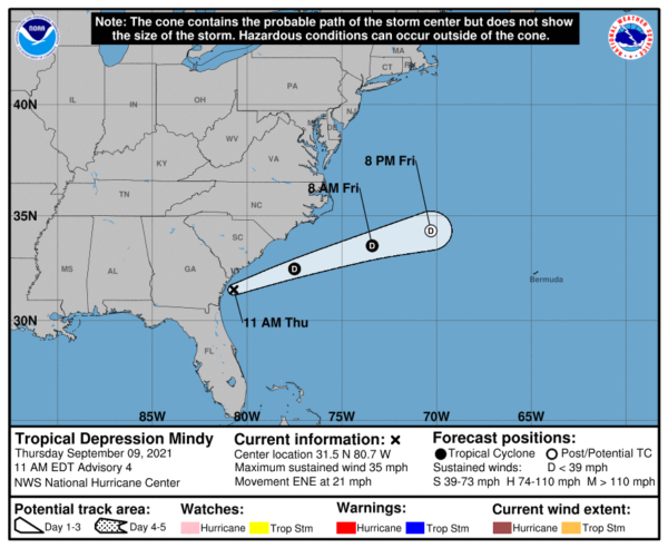
Maximum sustained winds are near 35 mph with higher gusts. Gradual weakening is forecast, and Mindy is expected to become a remnant low by Friday night. The estimated minimum central pressure is 1005 mb (29.68 inches).
BEACH FORECAST CENTER: Get the latest weather and rip current forecasts for the beaches from Fort Morgan to Panama City on our Beach Forecast Center page. There, you can select the forecast of the region that you are interested in visiting.
WORLD TEMPERATURE EXTREMES: Over the last 24 hours, the highest observation outside the U.S. was 120.0F at Yenbo, Saudia Arabia. The lowest observation was -97.1F at Vostok, Antarctica.
CONTIGUOUS TEMPERATURE EXTREMES: Over the last 24 hours, the highest observation was 120F at Death Valley, CA. The lowest observation was 15F at Peter Sinks, UT.
WEATHER ON THIS DATE IN 1921: A dying tropical depression unloaded 38.2 inches of rain upon the town of Thrall in southeastern Texas killing 224 persons. 36.4 inches fell in 18 hours.
Category: Alabama's Weather, ALL POSTS
About the Author (Author Profile)
Macon, Georgia Television Chief Meteorologist, Birmingham native, and long time Contributor on AlabamaWX. Stormchaser. I did not choose Weather, it chose Me. College Football Fanatic. @Ryan_StinnetSubscribe
If you enjoyed this article, subscribe to receive more just like it.


