

Midday Nowcast: Moisture Levels on the Rise
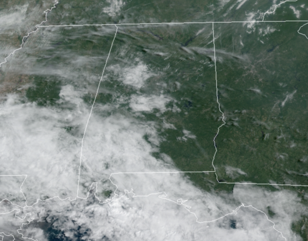
Moisture levels are on the rise today and we can feel that as dew points are increasing, it is not nearly as comfortable as it has been the past several days. The sky is partly sunny across Alabama today, and we are watching the radar as a few scattered showers could form this afternoon and tonight. Temperatures are heading into the mid to upper 80s this afternoon.
HIGHER RAIN CHANCES: Showers and storms will be more numerous tomorrow, and the weather will be pretty wet at times across the state Wednesday and Thursday due to Tropical Storm Nicholas to our west. Deep tropical moisture will be be pulled into Alabama these days, so look for periods of rain with some embedded thunderstorms both days with temperatures in the upper 70s and lower 80s because of clouds and rain.
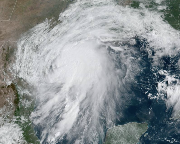
NICHOLAS: The center of Tropical Storm Nicholas was located by NOAA Doppler weather radars and an Air Force Reserve Reconnaissance aircraft near latitude 26.4 North, longitude 96.8 West. Nicholas is moving toward the north near 12 mph and
this general motion is expected to continue today, followed by a turn toward the north-northeast on Tuesday. On the forecast track, the center of Nicholas will pass near or just offshore of the coast of south Texas this morning and move onshore along the coast of south or central Texas late this afternoon or this evening.
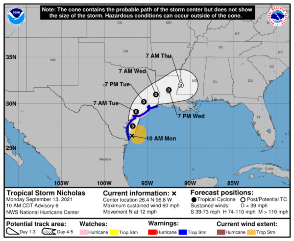
Data from the reconnaissance aircraft indicate that maximum sustained winds remain near 60 mph with higher gusts. Strengthening is forecast today, and Nicholas could reach the northwest Gulf coast as a hurricane. Weakening is anticipated on Tuesday and Wednesday while Nicholas moves over land. Tropical-storm-force winds extend outward up to 115 miles from the center. NOAA buoy 42020 located southeast of Corpus Christi, Texas, recently reported a sustained wind of 40 mph. The minimum central pressure recently measured by the aircraft is 1002 mb (29.59 inches).
FRIDAY AND THE WEEKEND: The moist airmass will remain in place meaning humidity levels will remain fairly high over the weekend, so we expect a mix of sun and clouds these three days with scattered showers and storms on a daily basis, mainly during the afternoon and evening hours. The chance of any one spot getting wet each day is 45-55 percent, and highs will be in the mid 80s.
ELSEWHERE IN THE TROPICS: Two likely areas of concern in the coming days, next two names are Odette and Peter.
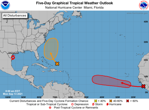
1. A tropical wave has emerged off the west coast of Africa near the coasts of Guinea and Sierra Leone. Environmental conditions are forecast to be conducive for gradual development of this disturbance, and a tropical depression is likely to form by late this week while the system moves westward at 10 to 15 mph across the eastern tropical Atlantic Ocean. Formation chance through 5 days…high…80 percent.
2. An area of low pressure is forecast to form by midweek a couple of hundred miles north of the southeastern or central Bahamas as a tropical wave interacts with an upper-level trough. Some gradual development of this system is possible thereafter, and a tropical depression could form later this week while the system moves north-northwestward or northward across the western Atlantic. Formation chance through 5 days…medium…50 percent.
BEACH FORECAST CENTER: Get the latest weather and rip current forecasts for the beaches from Fort Morgan to Panama City on our Beach Forecast Center page. There, you can select the forecast of the region that you are interested in visiting.
WORLD TEMPERATURE EXTREMES: Over the last 24 hours, the highest observation outside the U.S. was 114.3F at Ejido Nuevo Leon, Mexico. The lowest observation was -89.0F at Kohnen, Antarctica.
CONTIGUOUS TEMPERATURE EXTREMES: Over the last 24 hours, the highest observation was 114F at Death Valley, CA. The lowest observation was 26F at Mackay, ID.
WEATHER ON THIS DATE IN 1988: Hurricane Gilbert smashed into the Cayman Islands, and as it headed for the Yucatan peninsula of Mexico strengthened into a monster hurricane, packing winds of 175 mph. The barometric pressure at the center of Gilbert reached 26.13 inches (888 mb), an all-time record for any hurricane in the Caribbean, Gulf of Mexico, or the Atlantic Ocean at the time.
Category: Alabama's Weather, ALL POSTS
About the Author (Author Profile)
Macon, Georgia Television Chief Meteorologist, Birmingham native, and long time Contributor on AlabamaWX. Stormchaser. I did not choose Weather, it chose Me. College Football Fanatic. @Ryan_StinnetSubscribe
If you enjoyed this article, subscribe to receive more just like it.


