

7 pm Advisory — Heavy Rains, Strong Winds, & Storm Surges Continue to Pound the Central & Upper Texas Coasts
SUMMARY OF 700 PM CDT…0000 UTC…INFORMATION
———————————————-
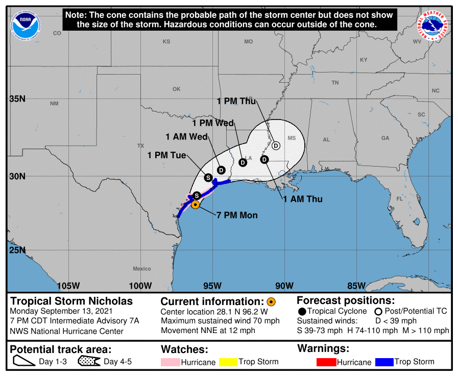
LOCATION…28.1N 96.2W
ABOUT 35 MI…60 KM SSW OF MATAGORDA, TEXAS
MAXIMUM SUSTAINED WINDS…70 MPH…110 KM/H
PRESENT MOVEMENT…NNE OR 15 DEGREES AT 12 MPH…19 KM/H
MINIMUM CENTRAL PRESSURE…988 MB…29.18 INCHES
WATCHES AND WARNINGS
——————–
A Storm Surge Warning is in effect for…
* Port Aransas Texas to Sabine Pass
* Galveston Bay, Aransas Bay, San Antonio Bay, and Matagorda Bay
A Hurricane Watch is in effect for…
* Port Aransas to San Luis Pass, Texas
A Tropical Storm Warning is in effect for…
* Baffin Bay to Sabine Pass
A Storm Surge Watch is in effect for…
* Sabine Pass to Rutherford Beach, Louisiana
DISCUSSION AND OUTLOOK
———————-
At 700 PM CDT (0000 UTC), the center of Tropical Storm Nicholas was located near latitude 28.1 North, longitude 96.2 West. Nicholas is moving toward the north-northeast near 12 mph (19 km/h) and this general motion is expected to continue through tonight, followed by a turn toward the northeast by late Tuesday. On the forecast track, the center of Nicholas is expected to make landfall along the central Texas coast later tonight.
Maximum sustained winds have increased to near 70 mph (110 km/h) with higher gusts. Some additional strengthening is possible during the next few hours, and Nicholas could become a hurricane when it reaches the Texas coast. Weakening is anticipated on Tuesday and Wednesday while Nicholas moves over land.
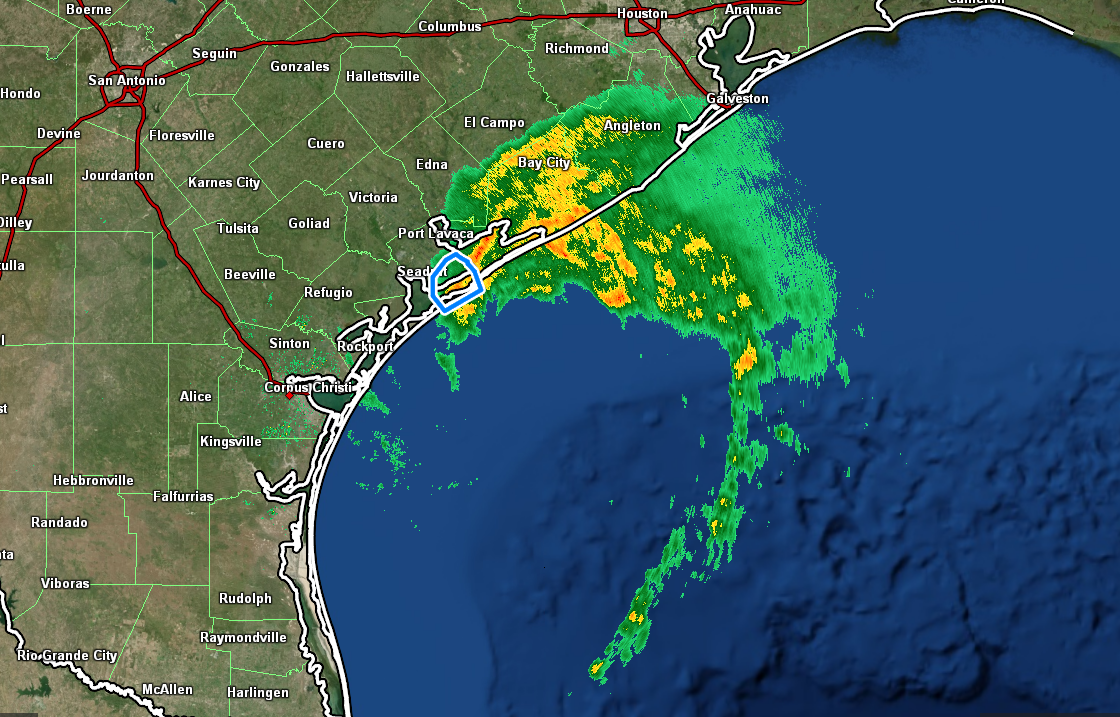
Tropical-storm-force winds extend outward up to 115 miles (185 km) from the center. A WeatherFlow station at Matagorda Bay recently reported a sustained wind of 55 mph (89 km/h) with a gust to 71 mph (115 km/h).
The estimated minimum central pressure is 988 mb (29.18 inches).
HAZARDS AFFECTING LAND
———————-
RAINFALL: Nicholas is expected to produce storm total rainfall of 6 to 12 inches, with isolated maximum amounts of 18 inches, across portions of the middle and upper Texas coastal areas through Wednesday. Life-threatening flash flooding impacts, especially in highly urbanized metropolitan areas, are possible across portions of the upper Texas Gulf Coast and far southwestern Louisiana.
Across interior southeast Texas into southern-central Louisiana and southern Mississippi, rainfall totals of 4 to 8 inches, with locally higher amounts near 10 inches, are expected through Thursday. This rainfall may produce areas of considerable flash and urban flooding.
The potential for minor to isolated moderate river flooding exists across the entire region, along with isolated major river flooding, especially in the smaller river basins and urban areas.
STORM SURGE: The combination of a dangerous storm surge and the tide will cause normally dry areas near the coast to be flooded by rising waters moving inland from the shoreline. The water could reach the following heights above ground somewhere in the indicated areas if the peak surge occurs at the time of high tide…
Port O’Connor, TX to San Luis Pass including Matagorda Bay…3-5 ft
San Luis Pass to Rutherford Beach, LA including Galveston Bay…2-4 ft
Port Aransas, TX to Port O’Connor, TX…2-4 ft
Aransas Bay and San Antonio Bay…2-4 ft
Rutherford Beach, LA to Intracoastal City, LA…1-3 ft
Sabine Lake and Calcasieu Lake…1-3 ft
Baffin Bay to Port Aransas, TX…1-3 ft
Corpus Christi Bay…1-3 ft
Mouth of the Rio Grande to Baffin Bay…1-2 ft
The deepest water will occur along the immediate coast in areas of onshore winds, where the surge will be accompanied by large and dangerous waves. Surge-related flooding depends on the relative timing of the surge and the tidal cycle, and can vary greatly over short distances. For information specific to your area, please see products issued by your local National Weather Service forecast office.
WIND: Tropical storm conditions are expected within the warning area across the central and upper Texas coasts through tonight, making outside preparations difficult or dangerous. Hurricane conditions are possible in the Hurricane Watch area as early as this evening.
TORNADOES: A couple of tornadoes will be possible through tonight, mainly along the upper Texas coast.
SURF: Swells generated by Nicholas will continue affecting portions of the northwest Gulf coast through Tuesday. These swells are likely to cause life-threatening surf and rip current conditions. Please consult products from your local weather office.
Category: ALL POSTS, Severe Weather, Tropical
About the Author (Author Profile)
Scott Martin is an operational meteorologist, professional graphic artist, musician, husband, and father. Not only is Scott a member of the National Weather Association, but he is also the Central Alabama Chapter of the NWA president. Scott is also the co-founder of Racecast Weather, which provides forecasts for many racing series across the USA. He also supplies forecasts for the BassMaster Elite Series events including the BassMaster Classic.Subscribe
If you enjoyed this article, subscribe to receive more just like it.


