

Wet At Times Through The Weekend
WET PATTERN DEVELOPING: A number of showers are in progress across Alabama this afternoon; they are moving slowly northward and producing moderate to heavy rain in spots. Otherwise, the sky is mostly cloudy with temperatures mostly in the 78-83 degree range. We will maintain the chance of showers statewide tonight.
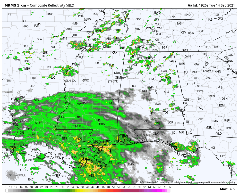
Tomorrow will be fairly wet day as the remnant circulation of Nicholas slowly dissipates over Louisiana; the sky will be cloudy with periods of rain and maybe a rumble or two of thunder. Temperatures will hold in the 70s all day because of clouds and rain.
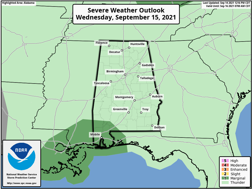
SPC continues a “marginal risk” of severe thunderstorms over the southwest corner of Alabama tomorrow where a brief tornado or waterspout will be possible. There is no risk of severe storms for any other part of the state.
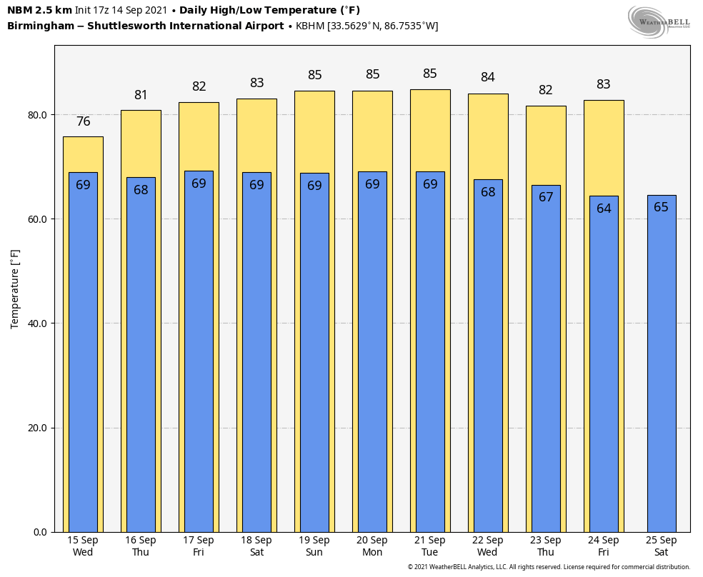
THURSDAY THROUGH THE WEEKEND: Although Nicholas will dissipate by Thursday morning, a deep layer of tropical moisture will linger over Alabama through the weekend. This means each day will be mostly cloudy, and we will deal with occasional showers and possibly a few thunderstorms. Not a total wash-out on any given day, but just be ready for rain at times if you have something planned outdoors. The chance of rain each day will run in the 50-70 percent range, and temperatures will remain below average due to the cloud cover. The high Thursday and Friday will be in the 77-80 degree range, followed by low 80s over the weekend.
NEXT WEEK: The moist air will linger, so there will be a risk of scattered showers and thunderstorms daily through the week; highs will be in the 80s. See the Weather Xtreme video for maps, graphics, and more details.
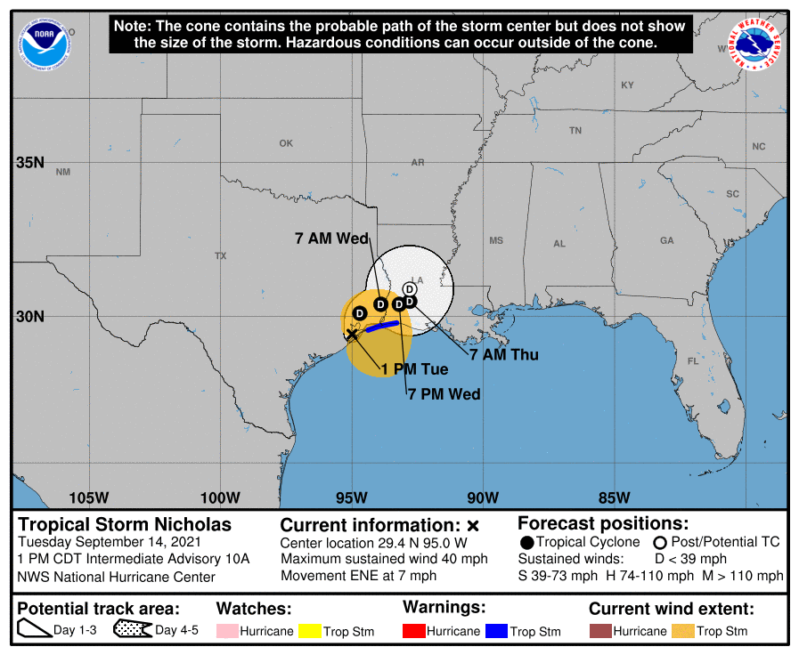
TROPICS: Tropical Storm Nicholas will likely be downgraded to a depression by the time you read this; it will dissipate over Louisiana by Thursday morning.
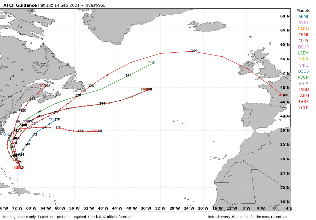
Elsewhere, Invest 96L is east of the Bahamas, and has a medium chance of becoming a tropical depression or storm over the next five days. It will move parallel to the U.S. East Coast, and will turn northeast out to sea by the weekend. The threat of landfall is very low.
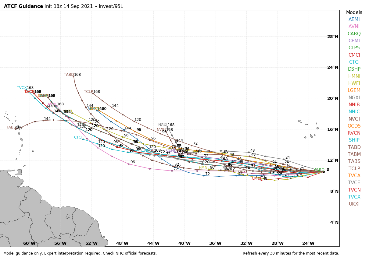
And, in the far eastern Atlantic Invest 95L has a high chance of becoming a tropical depression or storm over the next two days; the name will be “Odette”. It will move to the west/northwest over the next few days… there is a pretty good chance this one recurves into the Atlantic east of the U.S., but still too early to know for sure. We will keep an eye on it.
FOOTBALL WEATHER: Here is an early look at some college football weather forecasts for Saturday. Keep in mind this could change as we get closed to the weekend.
ALABAMA AT FLORIDA (2:30p CT kickoff): It will be a warm, humid day in Gainesville. The sun will be out at times, but there is a pretty decent chance of a few passing showers or thunderstorms during the game (take the rain gear)… temperatures will fall from near 87 at kickoff, into the low 80s by the fourth quarter.
AUBURN AT PENN STATE (6:30p CT kickoff): A passing shower can’t be ruled out during the game in State College (especially the first half), otherwise mostly fair with temperatures falling from around 80 at kickoff, into the low 70s by the final whistle.
UAB AT NORTH TEXAS (6:30p CT kickoff): The sky will be clear in Denton, Texas Saturday evening. Temperatures will fall from around 90 degrees at kickoff, to near 80 by the fourth quarter.
NORTH ALABAMA AT JACKSONVILLE STATE (6:00p CT kickoff): It will be a warm, humid Saturday night; a shower or storm can’t be ruled out, mainly during the first half. Temperatures will fall from near 80 at kickoff, into the mid 70s by the final whistle.
TROY AT SOUTHERN MISS (6:00p CT kickoff): A few showers are likely during the first half of the game, otherwise it will be a warm, humid night in Hattiesburg with temperatures falling from the low 80s into the upper 70s.
ON THIS DATE IN 2008: Hurricane Ike became extratropical on this day. The St. Louis Metropolitan Area experienced hurricane conditions, with Ike’s remnants inflicting severe damage to homes. Several areas in Illinois and Indiana, already flooded by the frontal boundary to the north, saw significant additional rainfall. Due to flooding in Chicago, a state of emergency was declared for Cook County due to flooding of the Des Plaines River. Hurricane-force wind gusts were reported to the east of the center across parts of Kentucky, Indiana, Ohio, and Pennsylvania with significant wind damage including structural damage to buildings and trees.
ON THIS DATE IN 2018: Florence made landfall in the United States just south of Wrightsville Beach, North Carolina as a Category 1 hurricane. Though Florence made landfall as a greatly weakened Category 1 hurricane, winds associated with the tropical cyclone were strong enough to uproot trees and power lines, causing extensive power outages across the Carolinas.
BEACH FORECAST: Click here to see the AlabamaWx Beach Forecast Center page.
WEATHER BRAINS: Don’t forget you can listen to our weekly 90 minute show anytime on your favorite podcast app. This is the show all about weather featuring many familiar voices, including our meteorologists here at ABC 33/40.
CONNECT: You can find me on all of the major social networks…
Look for the next Weather Xtreme video here by 6:00 a.m. tomorrow…
Category: Alabama's Weather, ALL POSTS, Weather Xtreme Videos
About the Author (Author Profile)
James Spann is one of the most recognized and trusted television meteorologists in the industry. He holds the AMS CCM designation and television seals from the AMS and NWA. He is a past winner of the Broadcast Meteorologist of the Year from both professional organizations.Subscribe
If you enjoyed this article, subscribe to receive more just like it.


