

Cloudy, Unsettled Weather Continues Through The Weekend
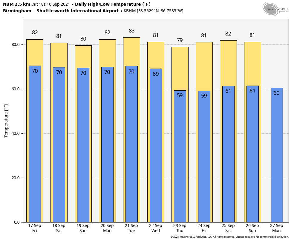
RADAR CHECK: We have large areas of mostly light rain across Alabama this afternoon, moving northward. We also note a few thunderstorms near the Gulf Coast, where a flash flood watch remains in effect… the watch includes Mobile, Baldwin, Washington, and Escambia counties in Alabama. Otherwise, the sky is generally cloudy with temperatures in the 77-81 degree range. The average high for Birmingham on September 16 is 86. Clouds will stay in place tonight with some light rain at times.
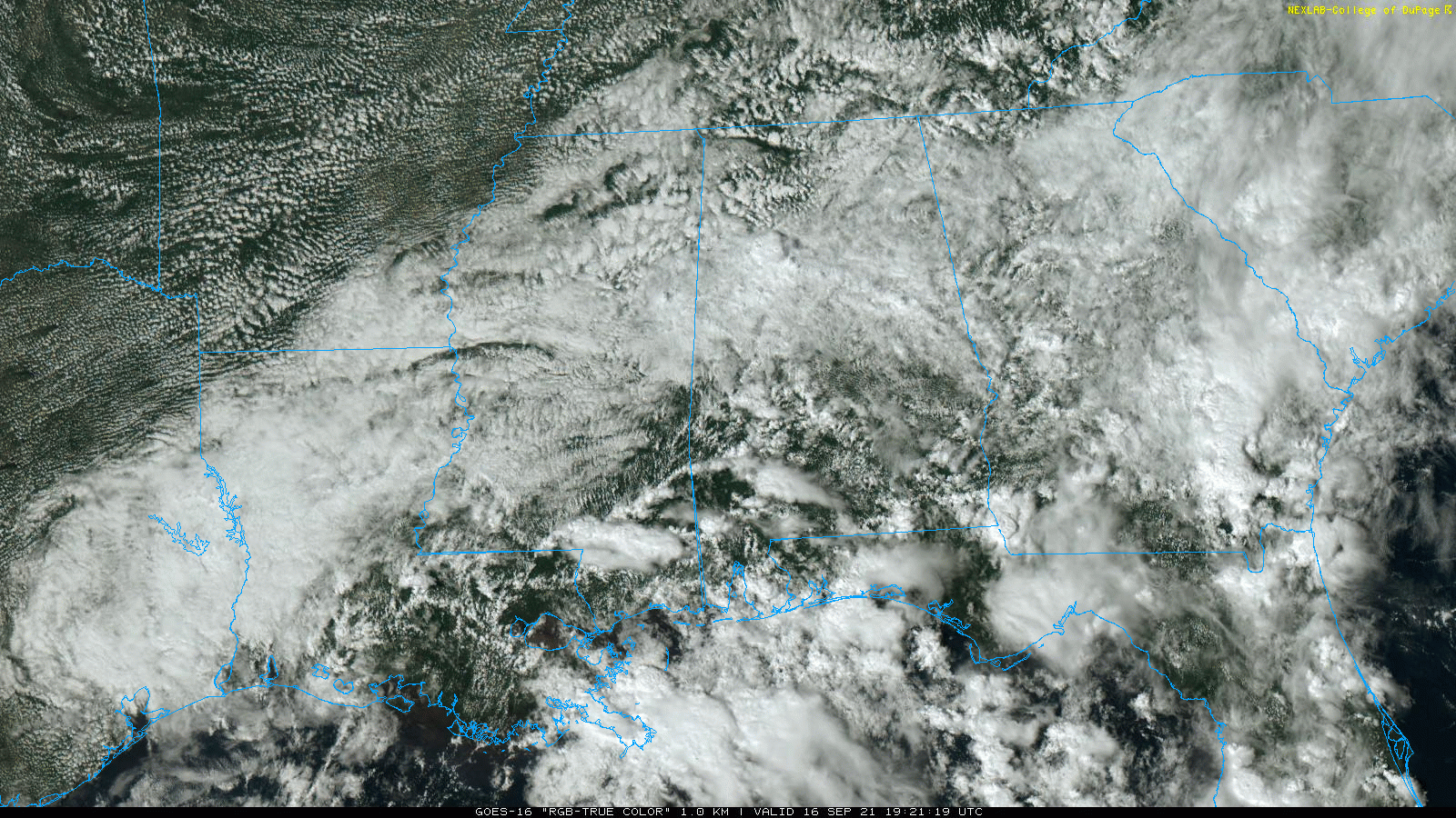
TOMORROW THROUGH THE WEEKEND: Not much change as a cloudy, unsettled pattern continues. Look for periods of rain each day through Sunday with a rumble of thunder possible. Not a wash-out by any means, but if you have something planned outdoors just know what some rain is likely at times. With only a limited amount of sun, temperatures will remain below average with highs between 76 and 80 degrees each day.
NEXT WEEK: The weather stays the same Monday through Wednesday with scattered to numerous showers and thunderstorms, but we are seeing increasing evidence that a drier airmass will move into the Deep South Thursday and Friday with increasing amounts of sun, lower humidity, and cooler nights. Highs through the week will be mostly in the low 80s… See the Weather Xtreme video for maps, graphics, and more details.
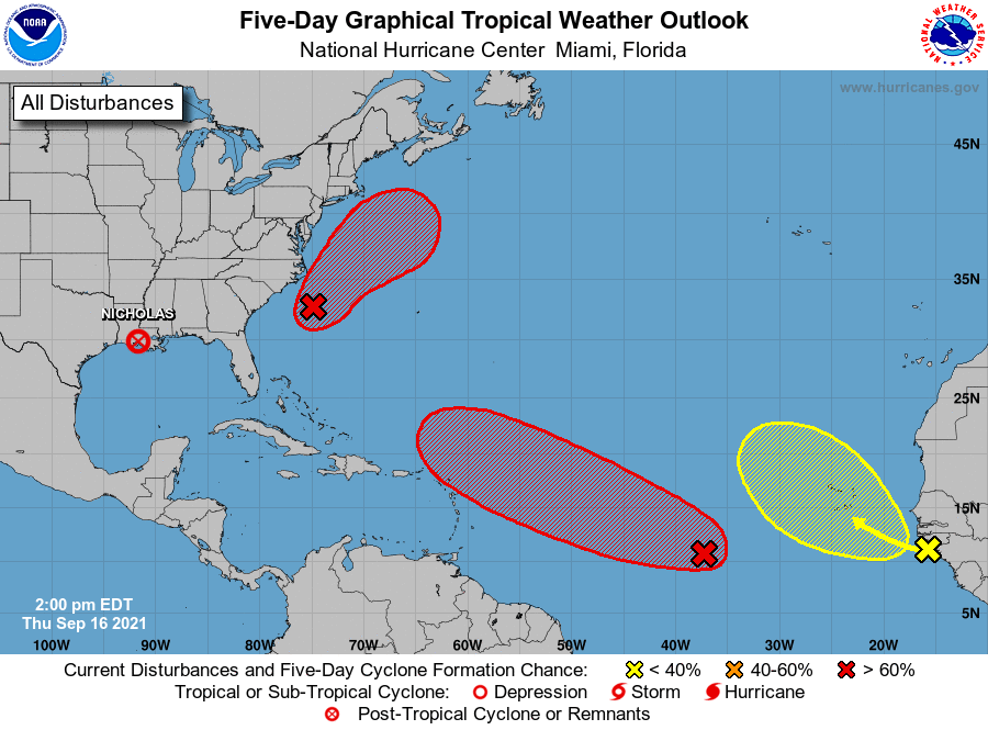
TROPICS: A tropical wave just east of the Carolinas has a high chance of becoming a tropical depression or storm within the next day or two, but it will move northeast, away from the U.S. Another tropical wave in the central Atlantic also has a high chance of development… models show this gaining latitude in 4-5 days, meaning this will likely recurve into the Atlantic east of the U.S.
Another wave coming off the coast of Africa has only a low chance of development. There are no tropical systems threatening the central Gulf Coast through next week.
FOOTBALL WEATHER: For the high school games Friday night, the sky will be mostly cloudy, showers are very possible, so take the rain gear (but it won’t rain at every stadium). Temperatures will fall slowly through 70s during the games.
ALABAMA AT FLORIDA (2:30p CT kickoff): It will be a warm, humid day in Gainesville. A few passing showers and thunderstorms are likely during the game (take the rain gear)… temperatures will fall from near 84 at kickoff, into the low 80s by the fourth quarter.
AUBURN AT PENN STATE (6:30p CT kickoff): A passing shower can’t be ruled out during the game in State College (especially the first half), otherwise mostly fair with temperatures falling from around 80 at kickoff, into the low 70s by the final whistle.
UAB AT NORTH TEXAS (6:30p CT kickoff): The sky will be clear in Denton, Texas Saturday evening. Temperatures will fall from around 90 degrees at kickoff, to near 80 by the fourth quarter.
NORTH ALABAMA AT JACKSONVILLE STATE (6:00p CT kickoff): It will be a warm, humid Saturday night; a shower or storm can’t be ruled out. Temperatures will fall from near 80 at kickoff, into the mid 70s by the final whistle.
TROY AT SOUTHERN MISS (6:00p CT kickoff): A few showers are likely during the first half of the game, otherwise it will be a warm, humid night in Hattiesburg with temperatures falling from the low 80s into the upper 70s.
ON THIS DATE IN 1928: The Okeechobee Hurricane, also known as the San Felipe Segundo Hurricane was one of the deadliest hurricanes in the history of the Atlantic basin. This Hurricane made landfall near West Palm Beach, Florida as a Category 4 storm during the evening hours of the 16th. The storm surge caused water to pour out of the southern edge of Lake Okeechobee, flooding hundreds of square miles as high as 20 feet. This storm killed over 4,000 people, including 2,500 in Florida.
ON THIS DATE IN 2004: Powerful Hurricane Ivan made landfall just west of Gulf Shores as an upper end Category 3 Hurricane. Ivan packed 120 mph sustained surface winds and a historic storm surge… the magnitude and extent of the damage and destruction over Baldwin County in Alabama and Escambia and Santa Rosa Counties in Northwest Florida exceeded that of both Hurricane Frederic (September 1979) and Hurricane Opal (October 1995).
Four days later, Ivan’s remnant surface low completed an anticyclonic loop and moved across the Florida peninsula. As it continued westward across the northern Gulf of Mexico, the system reorganized and again took on tropical characteristics on September 22. The National Weather Service determined that the low was in fact a result of the remnants of Ivan and thus named it accordingly. On the evening of September 23, the revived Ivan made another landfall near Cameron, Louisiana as a tropical depression.
ON THIS DATE IN 2020: Hurricane Sally made landfall in Gulf Shores as a strong Category 2 hurricane with maximum sustained winds of 105 mph. Sally produced widespread wind, storm surge, and freshwater flooding across coastal AL and the western Florida Panhandle. Flood and wind damage also extended well inland into inland southwest Alabama and south central Alabama. Sally was an extremely slow moving hurricane, which prolonged and exacerbated the local impacts. The storm was moving at less than 5 mph at the time of landfall, resulting in a long duration of tropical storm and hurricane force winds, storm surge, and torrential rainfall.
There were 3 direct fatalities as a result of Sally. One fatality occurred in the Wolf Bay area (Baldwin County AL.) Two men were riding the storm out on their boat and at some point during the storm attempted to swim to shore. One of the men made it to a pier and was rescued and hospitalised; the other man drowned. The second fatality occurred on Innerarity Point, FL (Escambia County FL) where a 45 year old woman drowned when the vehicle she was driving was overtaken by the incoming storm surge. The third fatality occurred in Perdido Key, FL (Escambia County FL) when a 27 year old man drowned trying to retrieve a boat that was swept away by the surge and high surf.
BEACH FORECAST: Click here to see the AlabamaWx Beach Forecast Center page.
WEATHER BRAINS: Don’t forget you can listen to our weekly 90 minute show anytime on your favorite podcast app. This is the show all about weather featuring many familiar voices, including our meteorologists here at ABC 33/40.
CONNECT: You can find me on all of the major social networks…
Look for the next Weather Xtreme video here by 6:00 a.m. tomorrow…
Category: Alabama's Weather, ALL POSTS, Weather Xtreme Videos
About the Author (Author Profile)
James Spann is one of the most recognized and trusted television meteorologists in the industry. He holds the AMS CCM designation and television seals from the AMS and NWA. He is a past winner of the Broadcast Meteorologist of the Year from both professional organizations.Subscribe
If you enjoyed this article, subscribe to receive more just like it.


