

Midday Nowcast: More Rain this Afternoon
New day, some forecast with plenty of clouds and numerous showers and areas of rain in the forecast again today. Much of Alabama is waterlogged and flash flooding remains a concern across much of the area and is why the flash flood watch continues through this evening at least.

The radar is active as showers are developing and lifting all towards the north at the midday hours, and temperatures are in the upper 70s and lower 80s across the state.
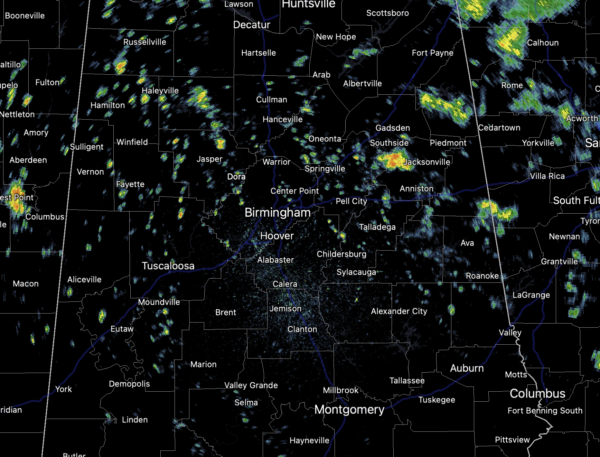
Rain will continue to be an issue at times overnight, and tomorrow the forecast doesn’t change. More cloud with numerous showers and storms.
MIDWEEK FRONT: On Wednesday, a potent front will swing through the state, finally clearing out all this tropical air and bring a much drier air mass back to Alabama. Rain chances remain high most of Wednesday, but will decrease from northwest to southeast as the front pushes through the state. Also Wednesday, fall officially arrives at 2:20 PM.
FANTASTIC FALL WEATHER: For Thursday and Friday, expect sunshine in fully supply, lower humidity and highs in the mid-70s; lows will be in the 50s. Some spots in North Alabama are likely to make a run at the 40s early Friday morning. The amazing fall weather will continue through the upcoming weekend as well, giving us a chance to finally dry out some after all the recent rains.
IN THE TROPICS: The National Hurricane Center is issuing advisories on Tropical Storm Peter, located east-northeast of the northernmost Leeward Islands, and on Tropical Storm Rose, located over the eastern tropical Atlantic Ocean, neither is a threat to the U.S. Also, there are two other areas of interest.
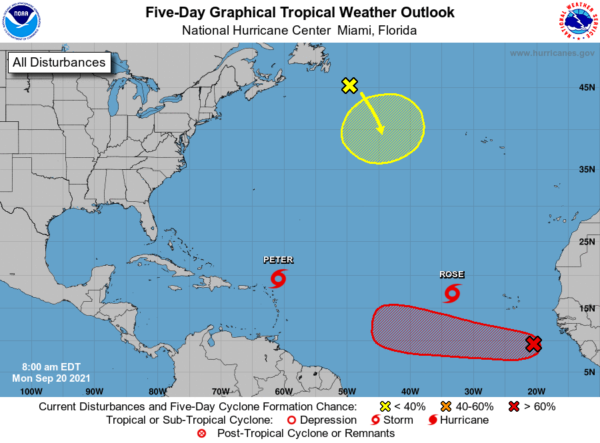
1. A tropical wave located over the far eastern tropical Atlantic several hundred miles south-southeast of the Cabo Verde Islands is producing an area of showers and thunderstorms that are showing some signs of organization. Upper-level winds are expected to become more conducive for further development by midweek, and a tropical depression is likely to form by Friday while the system moves westward at 10 to 15 mph across the eastern and central tropical Atlantic Ocean. Formation chance through 5 days…high…70 percent.
2. A storm-force, non-tropical low pressure system, the remnants of Odette, is located a couple of hundred miles southeast of Newfoundland. This low could acquire some subtropical characteristics by the middle of this week as it moves slowly southeastward over warmer waters across the north-central Atlantic Ocean before moving northward out of the area over the weekend. Formation chance through 5 days…low…30 percent.
BEACH FORECAST CENTER: Get the latest weather and rip current forecasts for the beaches from Fort Morgan to Panama City on our Beach Forecast Center page. There, you can select the forecast of the region that you are interested in visiting.
WORLD TEMPERATURE EXTREMES: Over the last 24 hours, the highest observation outside the U.S. was 113.4F at Jahra, Kuwait. The lowest observation was -97.1F at Vostok, Antarctica.
CONTIGUOUS TEMPERATURE EXTREMES: Over the last 24 hours, the highest observation was 106F at Zapata, TX. The lowest observation was 20F at Mackay, MT.
Category: Alabama's Weather, ALL POSTS
About the Author (Author Profile)
Macon, Georgia Television Chief Meteorologist, Birmingham native, and long time Contributor on AlabamaWX. Stormchaser. I did not choose Weather, it chose Me. College Football Fanatic. @Ryan_StinnetSubscribe
If you enjoyed this article, subscribe to receive more just like it.


