

Sam Becomes a Category 4 Hurricane; Teresa Degenerates Into an Open Low
Sam rapidly intensifies into a category 4 hurricane but continues to be no immediate threat to any land. While Sam continues to strengthen, Teresa has degenerated into a remnant low. Here’s the latest from the National Hurricane Center:
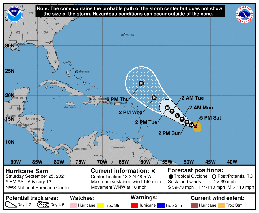
SUMMARY OF 500 PM AST…2100 UTC…INFORMATION
———————————————-
LOCATION…13.3N 48.5W
ABOUT 1025 MI…1655 KM ESE OF THE NORTHERN LEEWARD ISLANDS
MAXIMUM SUSTAINED WINDS…140 MPH…220 KM/H
PRESENT MOVEMENT…WNW OR 290 DEGREES AT 10 MPH…17 KM/H
MINIMUM CENTRAL PRESSURE…943 MB…27.85 INCHES
WATCHES AND WARNINGS
——————–
There are no coastal watches or warnings in effect.
DISCUSSION AND OUTLOOK
———————-
At 500 PM AST (2100 UTC), the center of Hurricane Sam was located near latitude 13.3 North, longitude 48.5 West. Sam is moving toward the west-northwest near 10 mph (17 km/h). A slower motion to the west-northwest is expected over the weekend, followed by a turn to the northwest on Monday.
Maximum sustained winds have increased to near near 140 mph (220 km/h) with higher gusts. Sam is now a category 4 hurricane on the Saffir-Simpson Hurricane Wind Scale. Additional strengthening is expected through tonight. Some fluctuations in the hurricane’s intensity are then possible early next week.
Sam remains a small hurricane. Hurricane-force winds extend outward up to 30 miles (45 km) from the center and tropical-storm-force winds extend outward up to 105 miles (165 km).
The estimated minimum central pressure is 943 mb (27.85 inches).
HAZARDS AFFECTING LAND
———————-
SURF: Swells generated by Sam are forecast to reach the Lesser Antilles early next week. These swells could cause life-threatening surf and rip current conditions. Please consult products from your local weather office.
About the Author (Author Profile)
Scott Martin is an operational meteorologist, professional graphic artist, musician, husband, and father. Not only is Scott a member of the National Weather Association, but he is also the Central Alabama Chapter of the NWA president. Scott is also the co-founder of Racecast Weather, which provides forecasts for many racing series across the USA. He also supplies forecasts for the BassMaster Elite Series events including the BassMaster Classic.Subscribe
If you enjoyed this article, subscribe to receive more just like it.


