

Midday Nowcast: Sunny and Dry until October
THE DOLDRUMS OF FALL: High pressure and dry air remain in place across the state and really the entire Southeast meaning our weather will remain quiet and pretty routine for early fall in Alabama.
The days will feature tons of sunshine and very warm temperatures with highs in the mid and upper 80s for most locations, while nights will be clear and nice with lows in the upper 50s and lower 60s. Late in the week, moisture levels will rise just west of the state, but I think these levels will remain low over Alabama so though more clouds are possible, I am just not sure we can get any showers to develop in Alabama and rain chances will remain less than 10%.
WEEKEND WEATHER: More of the same as the pattern will not change for the weekend. We are forecasting mainly sunny days both Saturday and Sunday with highs in the mid 80s. Lows will be near 60°.
NEXT WEEK: The weather pattern still looks relatively quiet and warm. Rain chances will remain under 20% with the relatively dry air mass in place. Highs next week will be in the 80s, while lows will hold in the 60s.
IN THE TROPICS: The National Hurricane Center is issuing advisories on Hurricane Sam, located several hundred miles east of the Lesser Antilles. We may also have Peter again, and Victor and Wanda.
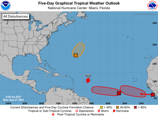
1. An elongated area of low pressure associated with the remnants of Peter is located a few hundred miles east-southeast of Bermuda. Showers and thunderstorms associated with this system have changed little in organization since yesterday. However, environmental conditions are marginally conducive for some further development, and Peter could briefly become a tropical depression again during the next day or two while it moves northeastward near 10 mph. By midweek, environmental conditions are expected to become unfavorable for further development. Formation chance through 5 days…medium…50 percent.
2. Disorganized showers and thunderstorms are associated with a broad area of low pressure located several hundred miles southwest of the Cabo Verde Islands. Environmental conditions are forecast to be conducive for further development of this disturbance, and a tropical depression is likely to form in a few days while it moves westward to west-northwestward at 5 to 10 mph over the central tropical Atlantic. Formation chance through 5 days…high…80 percent.
3. A tropical wave is moving offshore the west coast of Africa and into the far eastern tropical Atlantic. Upper-level winds are forecast to be conducive for gradual development, and a tropical depression is likely to form in a few days while the system moves westward to west-northwestward at 10 to 15 mph over the far eastern tropical Atlantic. Formation chance through 5 days…high…80 percent.
HURRICANE SAM: The center of Hurricane Sam was located near latitude 15.6 North, longitude 52.0 West. Sam is moving toward the northwest near 8 mph and this motion is expected to continue for the next few days, with an increase in forward speed beginning on Thursday. A turn to the north is expected on Friday. On the forecast track, Sam will pass well to the northeast of the northern Leeward Islands Wednesday and Thursday.
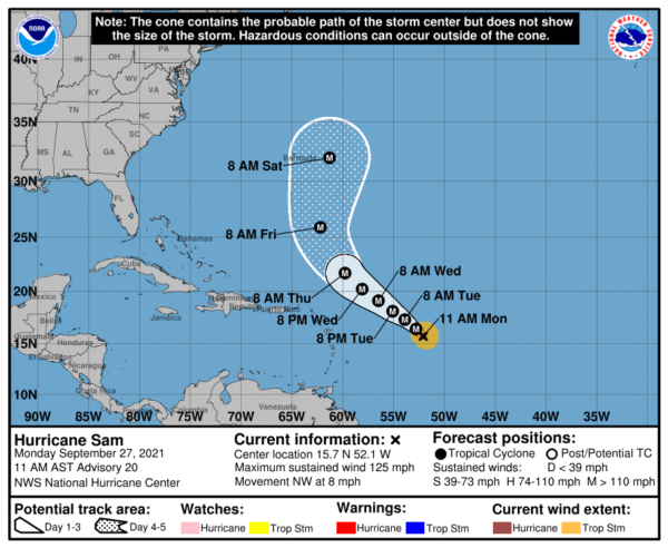
Maximum sustained winds are near 125 mph with higher gusts. Sam is a category 3 hurricane on the Saffir-Simpson Hurricane Wind Scale. Fluctuations in intensity are possible during the next days, although Sam is forecast to remain a major hurricane through at least Thursday night. Hurricane-force winds extend outward up to 30 miles from the center and tropical-storm-force winds extend outward up to 105 miles. The minimum central pressure estimated from NOAA Hurricane Hunter aircraft observations is 966 mb (28.53 inches).
BEACH FORECAST CENTER: Get the latest weather and rip current forecasts for the beaches from Fort Morgan to Panama City on our Beach Forecast Center page. There, you can select the forecast of the region that you are interested in visiting.
WORLD TEMPERATURE EXTREMES: Over the last 24 hours, the highest observation outside the U.S. was 112.5F at Reggane, Algeria. The lowest observation was -93.1F at Amundsen-Scott South Pole Station, Antarctica.
CONTIGUOUS TEMPERATURE EXTREMES: Over the last 24 hours, the highest observation was 107F at Death Valley, CA. The lowest observation was 17F at Peter Sinks, UT.
Category: Alabama's Weather, ALL POSTS
About the Author (Author Profile)
Macon, Georgia Television Chief Meteorologist, Birmingham native, and long time Contributor on AlabamaWX. Stormchaser. I did not choose Weather, it chose Me. College Football Fanatic. @Ryan_StinnetSubscribe
If you enjoyed this article, subscribe to receive more just like it.


