

Sam Forecast to Remain a Major Hurricane for the Next Few Days
SUMMARY OF 1100 PM AST…0300 UTC…INFORMATION
———————————————–
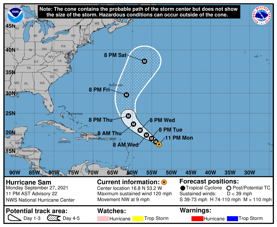
LOCATION…16.8N 53.2W
ABOUT 660 MI…1060 KM E OF THE NORTHERN LEEWARD ISLANDS
MAXIMUM SUSTAINED WINDS…120 MPH…195 KM/H
PRESENT MOVEMENT…NW OR 315 DEGREES AT 9 MPH…15 KM/H
MINIMUM CENTRAL PRESSURE…956 MB…28.23 INCHES
WATCHES AND WARNINGS
——————–
There are no coastal watches or warnings in effect.
DISCUSSION AND OUTLOOK
———————-
At 1100 PM AST (0300 UTC), the center of Hurricane Sam was located near latitude 16.8 North, longitude 53.2 West. Sam is moving toward the northwest near 9 mph (15 km/h), and this motion is expected to continue for the next few days, with an increase in forward speed beginning on Thursday. A turn to the north is expected by Friday. On the forecast track, Sam will pass well to the northeast of the northern Leeward Islands Wednesday and Thursday.
Data from a NOAA Hurricane Hunter plane indicate that maximum sustained winds remain near 120 mph (195 km/h) with higher gusts. Sam is a category 3 hurricane on the Saffir-Simpson Hurricane Wind Scale. The hurricane could strengthen some overnight, and Sam is anticipated to be a category 3 or 4 hurricane for the next several days.
Hurricane-force winds extend outward up to 40 miles (65 km) from the center and tropical-storm-force winds extend outward up to 125 miles (205 km).
The estimated minimum central pressure from NOAA aircraft data is 956 mb (28.23 inches).
HAZARDS AFFECTING LAND
———————-
SURF: Swells generated by Sam will impact the Lesser Antilles for the next several days. Swells are expected to reach Bermuda and the Bahamas mid-to-late week, and then spread to the United States east coast late this week. These swells could cause life-threatening surf and rip current conditions. Please consult products from your local weather office.
NEXT ADVISORY
————-
Next complete advisory at 500 AM AST.
About the Author (Author Profile)
Scott Martin is an operational meteorologist, professional graphic artist, musician, husband, and father. Not only is Scott a member of the National Weather Association, but he is also the Central Alabama Chapter of the NWA president. Scott is also the co-founder of Racecast Weather, which provides forecasts for many racing series across the USA. He also supplies forecasts for the BassMaster Elite Series events including the BassMaster Classic.Subscribe
If you enjoyed this article, subscribe to receive more just like it.


