

Sam Continues to Weaken While Victor Barely Remains a Tropical Depression Tonight
SAM GRADUALLY WEAKENING AS IT MOVES NORTHEASTWARD OVER THE OPEN ATLANTIC.
SUMMARY OF 1100 PM AST…0300 UTC…INFORMATION
———————————————–
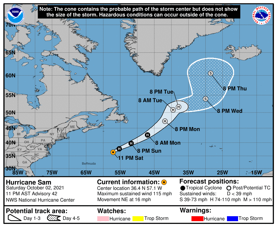
LOCATION…36.4N 57.1W
ABOUT 520 MI…840 KM NE OF BERMUDA
ABOUT 740 MI…1190 KM SSW OF CAPE RACE NEWFOUNDLAND
MAXIMUM SUSTAINED WINDS…115 MPH…185 KM/H
PRESENT MOVEMENT…NE OR 40 DEGREES AT 16 MPH…26 KM/H
MINIMUM CENTRAL PRESSURE…955 MB…28.20 INCHES
WATCHES AND WARNINGS
——————–
There are no coastal watches or warnings in effect.
DISCUSSION AND OUTLOOK
———————-
At 1100 PM AST (0300 UTC), the center of Hurricane Sam was located near latitude 36.4 North, longitude 57.1 West. Sam is moving toward the northeast near 16 mph (26 km/h). This general track with an increase in forward speed is expected for the next few days. On the forecast track, Sam will move well southeast and east of Newfoundland over the North Atlantic.
Maximum sustained winds are now near 115 mph (185 km/h) with higher gusts. Sam is a category 3 hurricane on the Saffir-Simpson Hurricane Wind Scale. Further slow weakening is anticipated during the next few days, and Sam could transition into a powerful post-tropical cyclone on Monday night.
Hurricane-force winds extend outward up to 70 miles (110 km) from the center, and tropical-storm-force winds extend outward up to 240 miles (390 km). The estimated minimum central pressure is 955 mb (28.20 inches).
HAZARDS AFFECTING LAND
———————-
SURF: Swells generated by Sam will impact the northern Leeward Islands, the Greater Antilles, the Bahamas, the eastern United States and Atlantic Canada for the next couple of days. These swells could cause life-threatening surf and rip current conditions. Please consult products from your local weather office.
VICTOR STILL A TROPICAL DEPRESSION.
FORECAST TO BECOME A REMNANT LOW IN THE NEXT DAY OR SO.
SUMMARY OF 1100 PM AST…0300 UTC…INFORMATION
———————————————–
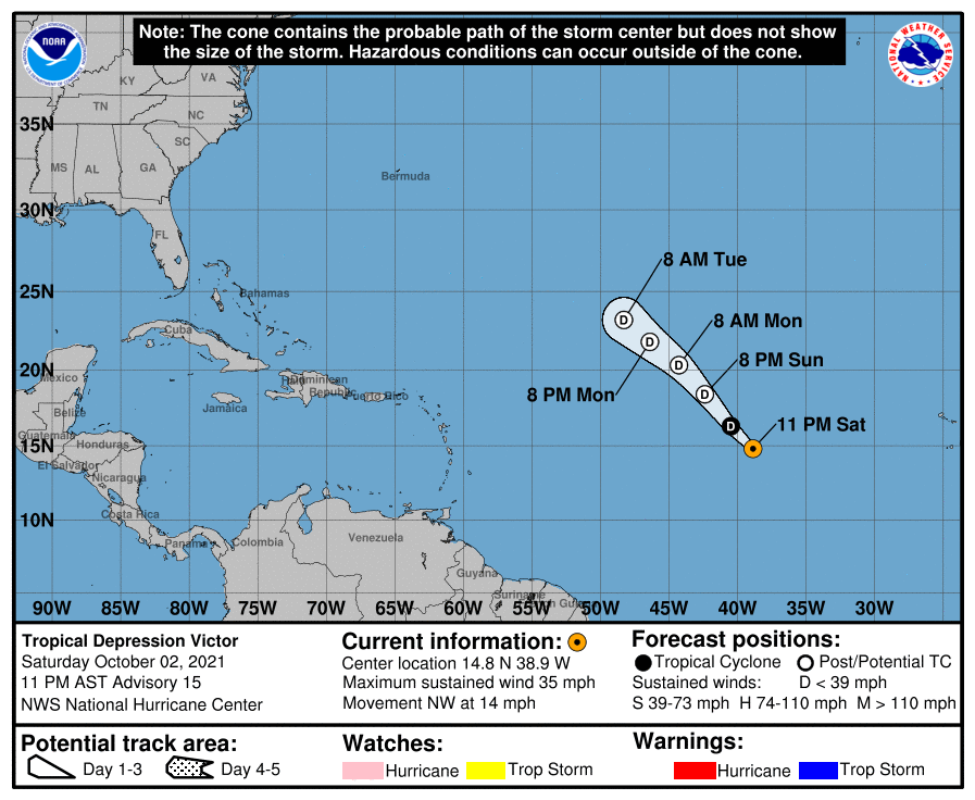
LOCATION…14.8N 38.9W
ABOUT 995 MI…1600 KM W OF THE CABO VERDE ISLANDS
MAXIMUM SUSTAINED WINDS…35 MPH…55 KM/H
PRESENT MOVEMENT…NW OR 310 DEGREES AT 14 MPH…22 KM/H
MINIMUM CENTRAL PRESSURE…1005 MB…29.68 INCHES
WATCHES AND WARNINGS
——————–
There are no coastal watches or warnings in effect.
DISCUSSION AND OUTLOOK
———————-
At 1100 PM AST (0300 UTC), the center of Tropical Depression Victor was located near latitude 14.8 North, longitude 38.9 West. The depression is moving toward the northwest near 14 mph (22 km/h) and this general motion is expected to continue over the next few days.
Maximum sustained winds are near 35 mph (55 km/h) with higher gusts. Gradual weakening is forecast over the next couple of days, and Victor could become a remnant low during that time. The system is then forecast to dissipate by Tuesday.
The estimated minimum central pressure is 1005 mb (29.68 inches). NOAA moored ocean buoy 13008 recently reported a sea level pressure of 1006.7 mb (29.73 inches).
HAZARDS AFFECTING LAND
———————-
None.
About the Author (Author Profile)
Scott Martin is an operational meteorologist, professional graphic artist, musician, husband, and father. Not only is Scott a member of the National Weather Association, but he is also the Central Alabama Chapter of the NWA president. Scott is also the co-founder of Racecast Weather, which provides forecasts for many racing series across the USA. He also supplies forecasts for the BassMaster Elite Series events including the BassMaster Classic.Subscribe
If you enjoyed this article, subscribe to receive more just like it.


