

Victor Degenerates into a Trough; Sam On Its Way to Be a Post-Tropical Cyclone Within 24 Hours
VICTOR DEGENERATES INTO A TROUGH OVER THE CENTRAL ATLANTIC.
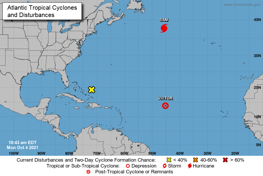
At 10:00 AM CDT (1500 UTC), the remnants of Victor were located near latitude 18.8 North, longitude 45.2 West, or around 1410 miles west of the Cabo Verde Islands. The remnants are moving toward the west-northwest near 15 mph, and this general motion is expected to continue through tonight. Recent satellite-derived wind data indicate that maximum sustained winds are near 30 mph with higher gusts. Weakening is forecast through tonight. The estimated minimum central pressure is 1011 mb (29.86 inches).
SAM MOVING QUICKLY NORTHEASTWARD, FORECAST TO BECOME A POWERFUL POST-TROPICAL CYCLONE TONIGHT OR EARLY TUESDAY.
At 1100 AM AST (1500 UTC), the center of Hurricane Sam was located near latitude 42.6 North, longitude 45.7 West, or about 460 miles southeast of Cape Race, Newfoundland. Sam is moving toward the northeast near 32 mph. A faster northeastward motion is expected through tonight. A slower east-northeastward motion is forecast to begin on Tuesday and continue through midweek.
Maximum sustained winds are near 100 mph, with higher gusts. Gradual weakening is forecast during the next few days, and Sam is expected to transition into a powerful post-tropical cyclone over the North Atlantic tonight or early Tuesday. Hurricane-force winds extend outward up to 60 miles from the center, and tropical-storm-force winds extend outward up to 275 miles. The estimated minimum central pressure is 960 mb (28.35 inches).
DISTURBANCE OVER THE SOUTHEASTERN BAHAMAS HAS A NEAR-ZERO CHANCE FOR DEVELOPMENT.
A large area of disorganized cloudiness and showers continues over the southeastern Bahamas and adjacent southwestern Atlantic waters in association with a surface trough. Upper-level winds are not expected to be especially conducive, and any development of this system should be slow to occur while it moves slowly northwestward through the end of this week.
* Formation chance through 48 hours… low… near 0 percent.
* Formation chance through 5 days… low… 10 percent.
About the Author (Author Profile)
Scott Martin is an operational meteorologist, professional graphic artist, musician, husband, and father. Not only is Scott a member of the National Weather Association, but he is also the Central Alabama Chapter of the NWA president. Scott is also the co-founder of Racecast Weather, which provides forecasts for many racing series across the USA. He also supplies forecasts for the BassMaster Elite Series events including the BassMaster Classic.Subscribe
If you enjoyed this article, subscribe to receive more just like it.


