

CANCELED — Severe T-Storm Warning: Parts of Jackson & Madison Co. Until 5:30 pm
The National Weather Service in Huntsville Alabama has issued a
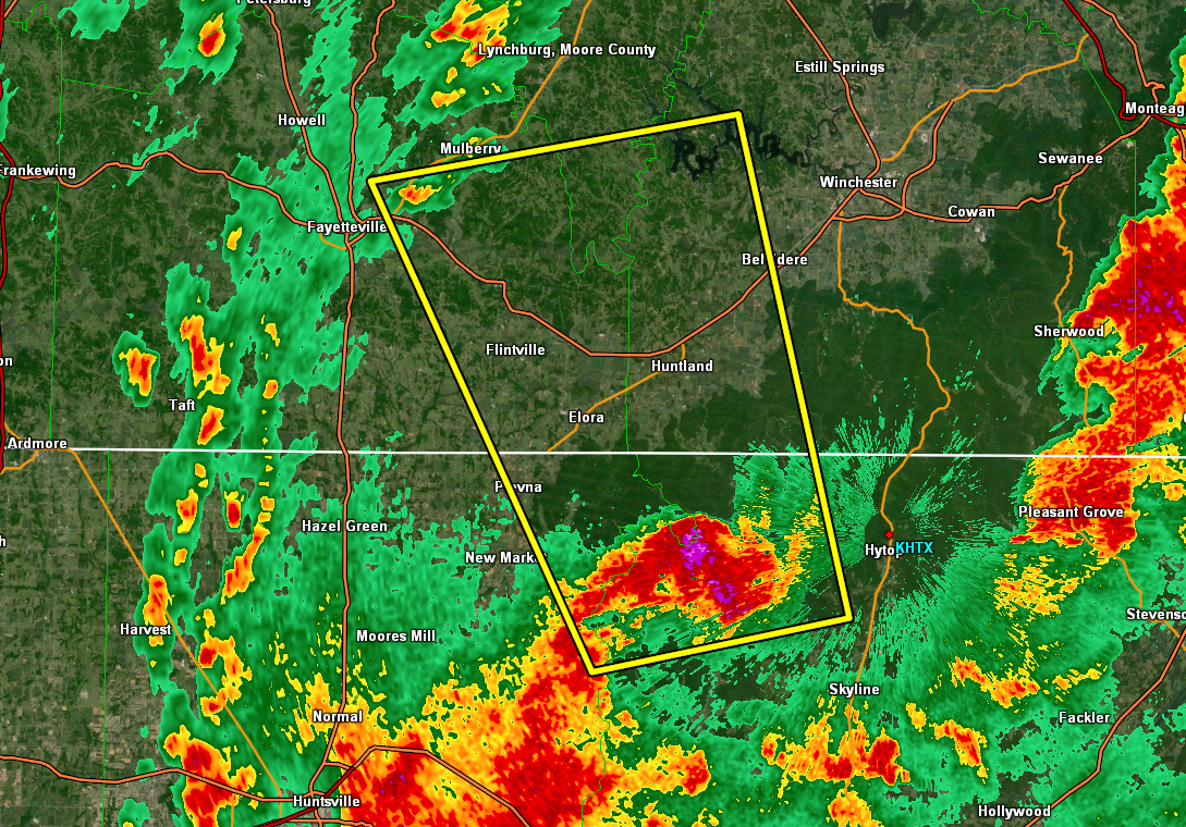
* Severe Thunderstorm Warning for…
Northwestern Jackson County in northeastern Alabama…
Northeastern Madison County in north central Alabama…
Southeastern Moore County in Middle Tennessee…
Southeastern Lincoln County in Middle Tennessee…
Southwestern Franklin County in Middle Tennessee…
* Until 530 PM CDT.
* At 454 PM CDT, a severe thunderstorm was located 8 miles south of
Huntland, or 15 miles northeast of Moores Mill, moving north at 30
mph.
HAZARD…60 mph wind gusts and quarter size hail.
SOURCE…Radar indicated.
IMPACT…Hail damage to vehicles is expected. Expect wind damage
to roofs, siding, and trees.
* Locations impacted include…
Huntland, Tims Ford Lake, Lexie Crossroads, Plevna, Harmony, Elora,
Estillfork, Hurdlow, Maxwell and Marble Hill.
PRECAUTIONARY/PREPAREDNESS ACTIONS…
A Tornado Watch remains in effect until 1000 PM CDT for north central
and northeastern Alabama…and Middle Tennessee.
For your protection move to an interior room on the lowest floor of a
building.
Torrential rainfall is occurring with this storm, and may lead to
flash flooding. Do not drive your vehicle through flooded roadways.
Category: Alabama's Weather, ALL POSTS, Severe Weather
About the Author (Author Profile)
Scott Martin is an operational meteorologist, professional graphic artist, musician, husband, and father. Not only is Scott a member of the National Weather Association, but he is also the Central Alabama Chapter of the NWA president. Scott is also the co-founder of Racecast Weather, which provides forecasts for many racing series across the USA. He also supplies forecasts for the BassMaster Elite Series events including the BassMaster Classic.Subscribe
If you enjoyed this article, subscribe to receive more just like it.


