

Midday Nowcast: Above Average Temperatures Continue
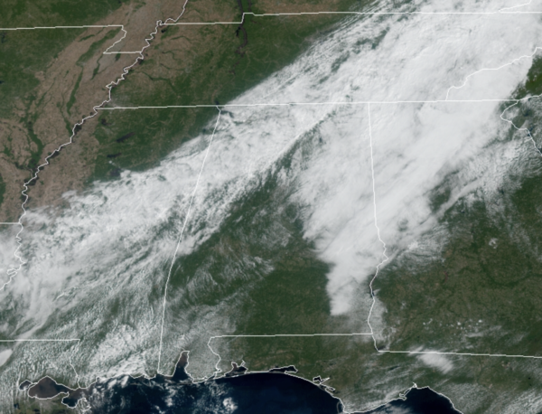
We are seeing a mix of sun and clouds today as a weak front dissipates over the state. A few locations may see a brief shower this afternoon, but rain chances are generally less than 20% and most spots stay dry. It will remain unseasonably warm with afternoon temperatures reaching the mid 80s.
USA BRIEF: Heavy snow and powerful winds in the Great Basin mountains, Rockies, and into the High Plains will create hazardous travel conditions. Strong winds will produce critical fire weather threats in portions of California and the Colorado Front Range.
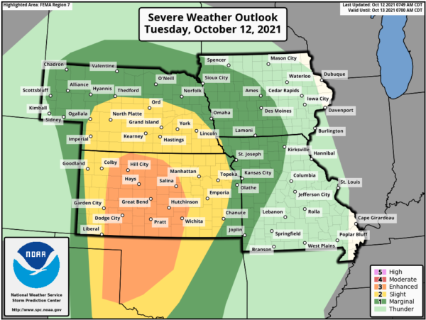
Severe thunderstorms may bring damaging wind gusts, large hail and tornadoes, including a few stronger ones, across parts of the central and southern Plains mainly this evening into tonight.
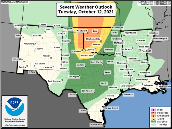
Heavy rain from the remnants of Hurricane Pamela may produce flash flooding across portions of Texas including the Dallas-Fort Worth Metro area on Wednesday.
REST OF WEEK: The weather will remain sunny and dry tomorrow and Thursday with highs remaining in the mid 80s. The day Friday will be warm and dry as well, but a cold front will cause clouds to increase late in the day with scattered showers and storms likely late Friday night and early Saturday; these should be after most of the Friday night football games. Limited moisture levels means rain amounts should not amount to much, and many locations are likely to stay dry.
FALL AIR RETURNS: The front passes through the state early Saturday with clouds and showers ending early in the day. By the afternoon, drier and cooler air spills into the state with a fresh north breeze, highs Saturday will be closer to 70°. Sunday will be a fantastic fall day with abundant sunshine and highs in the low 70s. Many North/Central Alabama communities will dip into the 40s early Sunday and Monday mornings.
NEXT WEEK: The week looks generally cool and dry with highs in the 70s and lows in the 50s as the fall air and quiet weather pattern will persist. Towards the end of the week, the models are suggesting some showers could return to the area as the front tries and lifts back north.
IN THE TROPICS: 1. A tropical wave located near the Windward Islands has continued to become less organized this morning and development of the system is not expected. Locally heavy rainfall and gusty winds will be possible across portions of the central and northern Lesser Antilles today. Formation chance through 5 days…low…near 0 percent.
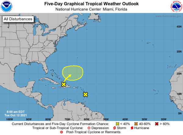
2. The northern portion of a tropical wave is producing a large area of disorganized showers and thunderstorms across Hispaniola, the Turks and Caicos, and the southeastern Bahamas. Development of this system, if any, will be slow to occur during the next couple of days due to unfavorable environmental conditions. The system is expected to interact with a front by the end of the week and further development is unlikely after that time. Regardless of development, locally heavy rainfall is possible over portions of Hispaniola, the Turks and Caicos, and the southeastern Bahamas during the next day or two.* Formation chance through 5 days…low…10 percent.
BEACH FORECAST CENTER: Get the latest weather and rip current forecasts for the beaches from Fort Morgan to Panama City on our Beach Forecast Center page. There, you can select the forecast of the region that you are interested in visiting.
WORLD TEMPERATURE EXTREMES: Over the last 24 hours, the highest observation outside the U.S. was 110.1F at Asswan, Egypt. The lowest observation was -85.7F at Dome A, Antarctica.
CONTIGUOUS TEMPERATURE EXTREMES: Over the last 24 hours, the highest observation was 99F at Rio Grande Village, TX. The lowest observation was 15F at Polebridge, MT.
WEATHER ON THIS DATE IN 1918: Forest fires ravaged parts of Minnesota from the Duluth area northeastward, claiming the lives of 600 persons. Smoke with a smell of burnt wood spread to Albany NY and Washington D.C. in 24 hours. Smoke was noted at Charleston SC on the 14th, and by the 15th was reported in northeastern Texas.
Category: Alabama's Weather, ALL POSTS
About the Author (Author Profile)
Macon, Georgia Television Chief Meteorologist, Birmingham native, and long time Contributor on AlabamaWX. Stormchaser. I did not choose Weather, it chose Me. College Football Fanatic. @Ryan_StinnetSubscribe
If you enjoyed this article, subscribe to receive more just like it.


