

Midday Nowcast: Cold Front Arrives Tonight
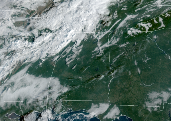
It is the last very warm day for a while as the much anticipated front inches closer to Alabama. The weather is partly sunny with highs in the mid 80s. Most communities will be dry during the day, but a few showers and storms are ongoing over the Tennessee Valley, especially the northwest corner of the state today.
FRIDAY NIGHT LIGHTS: For the high school games tonight, it now looks like most stadiums will be dry…the best chance of showers will come after 10PM. The sky will be mostly cloudy with temperatures in the 70s.
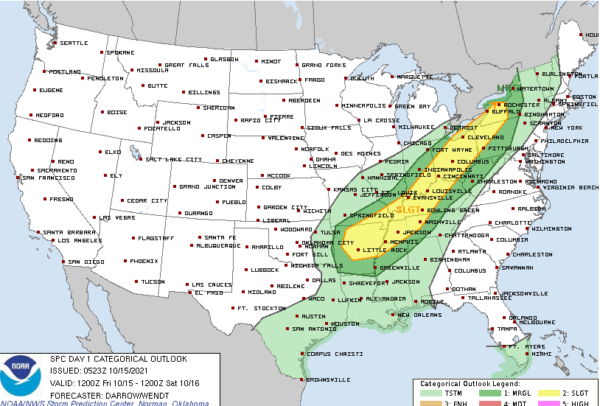
FRONT ARRIVES TONIGHT: Showers and storms will develop ahead of the front to our northwest today, where some severe storms are possible. The SPC has far northwest corner of the of Alabama in a “slight risk” (level 2/5) of severe thunderstorms, while much of Northwest Alabama is in a “marginal risk” (level 1/5) but the storms will be weakening rapidly as they arrive.
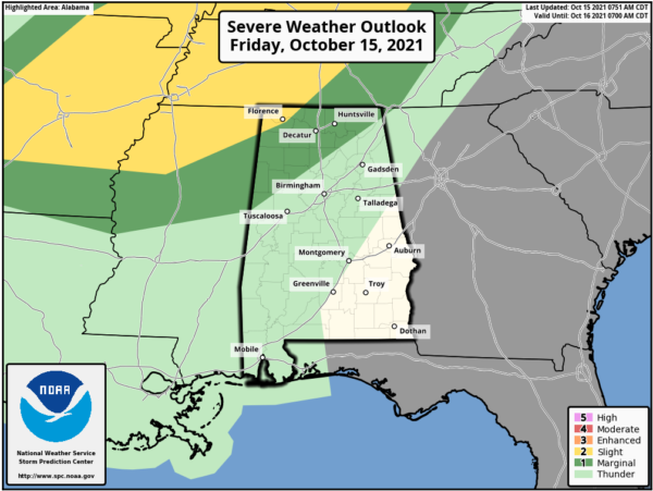
The better chance for severe storms today stretches from Arkansas into the Tennessee and Kentucky.
As the front moves into and through the state, a weakening, narrow band of showers will continue to advance southward ahead of the front through the state late tonight. The main window for these showers will be after 10PM and through the predawn hours Saturday. Rainfall amounts will be generally under a quarter of an inch, and most of the showers will dissipate before reaching South Alabama early tomorrow morning.
FEELING LIKE FALL: By the time most of us wake up in the morning, the front will be in South Alabama and any clouds leftover in the morning will quickly give way to sunshine. Tomorrow will be mainly sunny, much cooler, and breezy day with highs in the upper 60s; expect a gusty north wind of 10-25 mph. Saturday night will be a clear and chilly one with a diminishing wind, we project a lows early Sunday morning in the low and mid 40s. Sunday will be a fantastic fall day with abundant sunshine with a highs near 70°. Sunday night will be another chilly one with widespread 40s, and both Sunday and Monday mornings, I would not be surprised to see some 30s in those colder spots. This will be coldest air so far this season for most communities.
FOOTBALL FORECAST: AUBURN AT ARKANSAS (11a CT kickoff in Fayetteville): A beautiful fall day in Arkansas. Sunshine in full supply with temperatures rising from 62 at kickoff into the mid 60s by the second half.
SAMFORD AT WOFFORD: (2:30p CT kickoff in Spartanburg, SC): Expect a partly sunny sky; a shower is possible late in the game. Temperatures will be in the 70s.
JACKSONVILLE STATE AT SAM HOUSTON STATE: (2:00p CT kickoff in Huntsville, Texas): A sunny day with temperatures falling from near 75 at kickoff, into the upper 60s by the final whistle.
TROY AT TEXAS STATE: (2:00p CT kickoff in San Marcos, TX): A cloudless sky; lots of sunshine with temperatures in the 70s.
UAB AT SOUTHERN MISS: (2:30p CT kickoff in Hattiesburg): It will be a fun filled day; the temperature at kickoff will be near 73 degrees, falling into the upper 60s by the fourth quarter.
ALABAMA AT MISSISSIPPI STATE (6:00p CT kickoff in Starkville): Perfect football weather. A clear sky with temperatures falling from near 67 at kickoff, into the 50s by the second half.
NEXT WEEK: The week starts off cool and dry with highs in the 70s and lows in the 50s as the fall air and quiet weather pattern will persist most of the week. Late Thursday and Friday, the models are still suggesting some showers return to the area with a feature lifting out of the Gulf. This would be a quick hitting system with another cooler and drier air mass arriving by the following weekend.
BEACH FORECAST CENTER: Get the latest weather and rip current forecasts for the beaches from Fort Morgan to Panama City on our Beach Forecast Center page. There, you can select the forecast of the region that you are interested in visiting.
WORLD TEMPERATURE EXTREMES: Over the last 24 hours, the highest observation outside the U.S. was 110.1F at Big Bend, Swaziland. The lowest observation was -79.6F at Vostok, Antarctica.
CONTIGUOUS TEMPERATURE EXTREMES: Over the last 24 hours, the highest observation was 102F at Falcon Lake, TX. The lowest observation was 8F at Vernal, UT.
Category: Alabama's Weather, ALL POSTS
About the Author (Author Profile)
Macon, Georgia Television Chief Meteorologist, Birmingham native, and long time Contributor on AlabamaWX. Stormchaser. I did not choose Weather, it chose Me. College Football Fanatic. @Ryan_StinnetSubscribe
If you enjoyed this article, subscribe to receive more just like it.


