

It’s Chamber of Commerce Weather Out There at Midday
AN INCREDIBLE SATURDAY: The fog has lifted and dissipated, and we are enjoying what we call “chamber of commerce” weather across Central Alabama as we have crossed over into the midday hour. Skies are sunny and temperatures have climbed into the mid-60s to the lower 70s. Alexander City, Gadsden, and Pell City were tied as the cool spots at 66 degrees. The warm spots were Demopolis, Troy, and Tuscaloosa at 73 degrees. Birmingham was sitting at 68 degrees. Afternoon highs will eventually climb into the mid to upper 70s across the area before the sun starts to set this evening. For the evening and nighttime hours, skies will remain clear with temperatures slowly falling into the upper 60s to the lower 70s by 6 pm, into the mid-50s to the lower 60s by 10 pm, and eventually into the upper 40s to the mid-50s for the overnight low.
A WARMER SUNDAY: We will have a system approaching from the west that will put us in a southerly flow, allowing an increased flow of warmer and more humid air. The good news is that we’ll stay bright and dry with mostly sunny skies, but clouds will begin to increase late into the day and through the late-night and overnight hours. Highs will be in the upper 70s to the lower 80s.
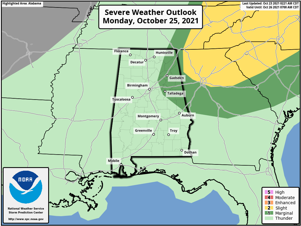
A FEW STORMS POSSIBLE ON MONDAY: A surface low will be moving through the Great Lakes region and will be pulling a cold front that will move through Central Alabama on Monday. Showers and storms will be possible throughout the day and into the evening hours, mainly for the northern two-thirds of the area. While there is not a threat of widespread severe weather, there is the possibility of a couple stronger storms over the eastern and northeastern parts of the area. SPC has outlined those locations in a marginal risk for severe storms for Monday. Highs will be in the mid-70s to the mid-80s.
AN IN-BETWEEN DAY ON TUESDAY: Just as this paragraph’s title states, Tuesday will be a day when Central Alabama will be in-between two systems. We’ll have a small ridge of high-pressure work into the area just for the day before another storm system moves in on Wednesday. Skies will be mainly sunny, with highs in the mid-70s to the lower 80s.
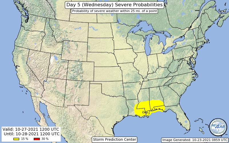
STRONG TO SEVERE STORMS POSSIBLE ON WEDNESDAY: A trough will be working its way through the eastern half of the country and will send another front through the area on Wednesday. This time, we will have some of the better dynamics in place for where we could see a few strong to severe storms across Central Alabama, especially during the afternoon and evening hours. SPC has already defined the extreme southern portions of Central Alabama and all of South Alabama in a 15% risk of severe storms on their Day Five Severe Weather Outlook, which would equate to a slight risk. More than likely, the rest of the area may be placed in a marginal risk as stronger to one or two severe storms will be possible. While it is still early, we’ll have to watch to see if these risk areas get adjusted over the next couple of days, especially when the higher-rseolution models come into view. Damaging winds, large hail, and a brief spin-up tornado look to be possible with any severe storm in the risk area, so we will all need to be weather aware. Highs will be in the upper 60s to the upper 70s.
A FEW SHOWERS REMAIN POSSIBLE TO END THE WORKWEEK: The trough will be a slow mover and with the central surface low remaining just off to our north and northeast, we’ll continue to have a chance of a few passing showers mainly over the northern half of the area on both Thursday and Friday, with the southern half staying dry. Thursday’s highs will be in the mid-60s to the lower 70s, then dipping into the upper 50s to the mid-60s on Friday.
A SNEAK PEEK INTO THE HALLOWEEN WEEKEND: The trough remains but has shifted a little farther to the east on Saturday, unfortunately it is still too close to Central Alabama that will keep a chance of a few showers in the forecast during most of the daylight hours. The trough finally gets a kick in its rear by another system which will dry us out for Sunday, which will make those Trick-or-Treaters happy on Sunday night. Saturday’s highs look to be in the 60s, then warming into the mid-60s to the lower 70s on Sunday. This could change as this is out there in Voodoo Land, so stay tuned.
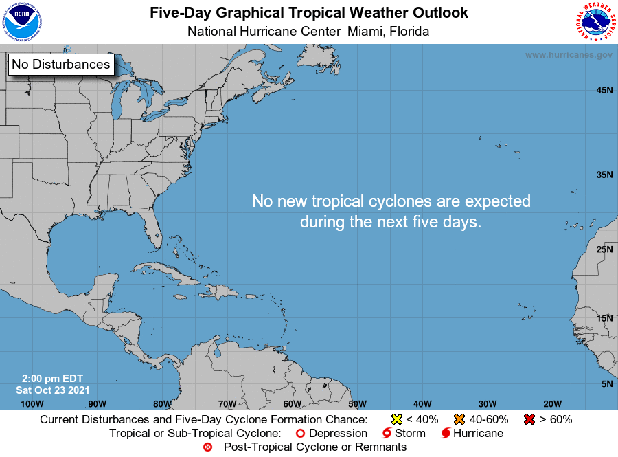
THE TROPICS: The tropics remain astonishingly quiet, and no new tropical cyclones are expected to develop within the next five days. Remember, the end of the season doesn’t arrive until the end of the day on November 30th.
Category: Alabama's Weather, ALL POSTS, Severe Weather, Tropical
About the Author (Author Profile)
Scott Martin is an operational meteorologist, professional graphic artist, musician, husband, and father. Not only is Scott a member of the National Weather Association, but he is also the Central Alabama Chapter of the NWA president. Scott is also the co-founder of Racecast Weather, which provides forecasts for many racing series across the USA. He also supplies forecasts for the BassMaster Elite Series events including the BassMaster Classic.Subscribe
If you enjoyed this article, subscribe to receive more just like it.


