

Colder Air Rolling Into Alabama; Freeze Possible Early Tomorrow
ON THE MAPS: A cold front bisects Alabama this afternoon. North of the front, temperatures are only in the 40s and low 50s with a brisk north wind, but south of the front it is close to 80 degrees across the southeast counties of the state. A few rain showers continue in the colder air just north of the front at mid-afternoon… that rain will end soon and the sky will clear this evening.
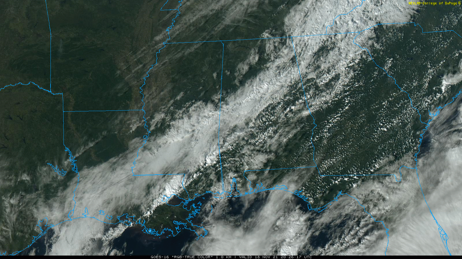
Temperatures will continue to drop tonight, and a freeze is likely in many places early tomorrow morning. Look for a low in the 27-34 degree range for most communities.
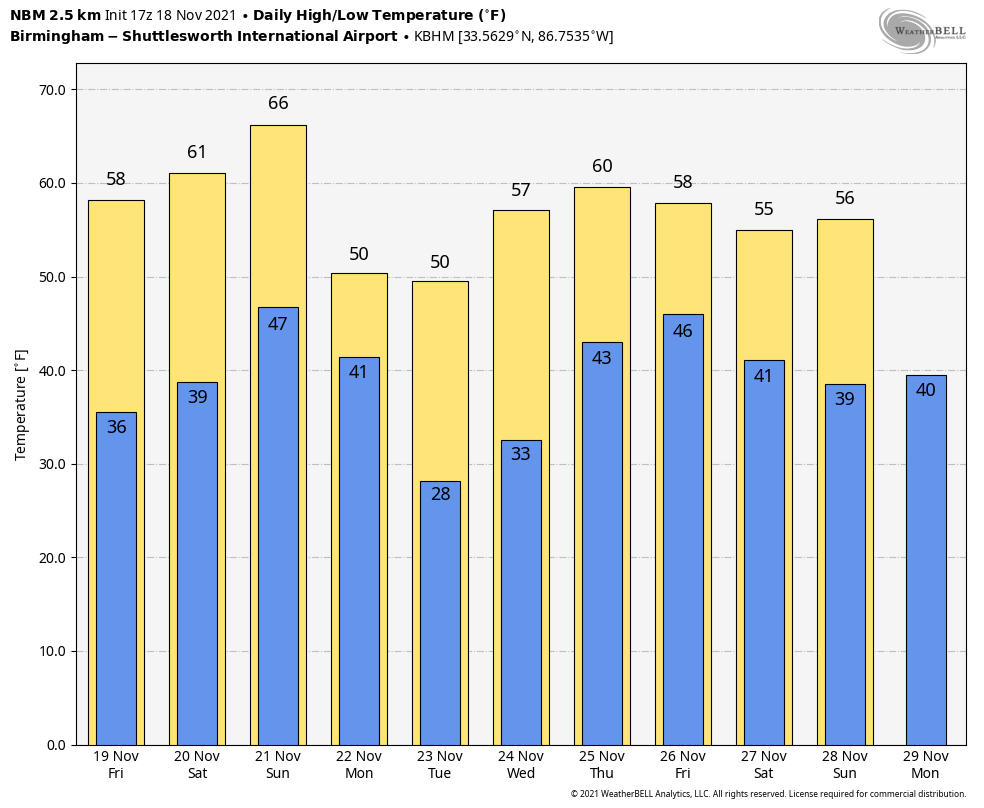
TOMORROW AND THE WEEKEND: Tomorrow will be sunny and cool with a high between 57 and 61 degrees… then we reach the mid 60s Saturday afternoon with a good supply of sunshine. The day Sunday will be dry with a high in the 60s, but clouds will increase late in the day. Rain returns to the state Sunday night ahead of another cold front.
THANKSGIVING WEEK: Rain ends very early in the day Monday, followed by a clearing sky. Another shot of colder arrives… temperatures will hold in the 40s over much of North Alabama Monday afternoon. Tuesday morning will bring the coldest temperatures so far this season; look for a low between 22 and 28 degrees.
Tuesday and Wednesday will be mostly sunny but cool with highs in the 50s. The latest global model data set suggests Thanksgiving Day will remain cool and dry with a high in the 56-60 degree range. Then, some rain is possible Friday as a disturbance approaches from the west. Too early to know if rain will be an issue for the Iron Bowl this year… See the Weather Xtreme video for maps, graphics, and more details.
LUNAR ECLIPSE LATE TONIGHT: We will be able to see a “near-total” lunar eclipse after midnight tonight. 99.1% of the Moon will be in Earth’s shadow at maximum eclipse at 3:03 am CT… the sky will be clear over Alabama. While the statement “longest partial eclipse of the decade” is technically true, it is not that significant. Next year’s total lunar eclipse on May 16 total (visible from Americas, western Africa & Europe) will be one minute shorter.
FOOTBALL WEATHER: For the high school games tomorrow night, the sky will be clear with temperatures falling through the 40s, possibly reaching the upper 30s by the final whistle.
For the college games Saturday…
HUNTINGDON AT BIRMINGHAM SOUTHERN (12:00p CT kickoff at General Krulak Stadium): A sunny day for football with temperatures in the 60-65 degree range.
FURMAN AT SAMFORD (12:00p CT kickoff at Seibert Stadium): The sky will be sunny with temperatures in the low to mid 60s.
NORTH ALABAMA AT HAMPTON (12:00p CT kickoff at Hampton, VA): The sky will be sunny with temperatures in the 50-55 degree range during the game.
JACKSONVILLE STATE AT EASTERN KENTUCKY (1:00p CT kickoff in Richmond, KY): The sky will be partly sunny; kickoff temperature near 52 degrees, holding in the low to mid 50s during the game.
ARKANSAS AT ALABAMA (2:30p CT kickoff at Bryant-Denny Stadium): It will be a sunny afternoon with a kickoff temperature around 65 degrees… falling into the 50s by the fourth quarter.
UAB AT USTA (2:30p CT kickoff in San Antonio, TX): This game will be played inside the Alamodome. Outside, the sky will partly sunny with afternoon temperatures in the low to mid 70s.
APPALACHIAN STATE AT TROY (2:30p CT kickoff at Veterans Memorial Stadium): The sky will be sunny; about 68 degrees at kickoff, falling to near 60 by the final whistle.
AUBURN AT SOUTH CAROLINA (6:00p CT kickoff in Columbia, SC): The weather will be clear and cool; temperatures will fall from near 52 at kickoff, to near 45 by the final whistle.
SOUTH ALABAMA AT TENNESSEE (6:30p CT kickoff in Knoxville, TN): The sky becomes mostly cloudy with temperatures falling through the 40s. No risk of rain.
ON THIS DATE IN 1957: An F2 tornado moved through the western and northern part of the Birmingham metro. After touching down in Ensley, the tornado moved northeast through the Pratt area and North Birmingham and eventually into Tarrant. Many homes between 22nd and 24th streets on 35th and 36th Avenues North were damaged with numerous large trees down around the area. The Birmingham Airport reported winds of 69 mph and sited the funnel just to the northwest. Damage in Tarrant was mainly to the industrial area.
BEACH FORECAST: Click here to see the AlabamaWx Beach Forecast Center page.
WEATHER BRAINS: Don’t forget you can listen to our weekly 90 minute show anytime on your favorite podcast app. This is the show all about weather featuring many familiar voices, including our meteorologists here at ABC 33/40.
CONNECT: You can find me on all of the major social networks…
Look for the next Weather Xtreme video here by 6:00 a.m. tomorrow…
Category: Alabama's Weather, ALL POSTS, Weather Xtreme Videos
About the Author (Author Profile)
James Spann is one of the most recognized and trusted television meteorologists in the industry. He holds the AMS CCM designation and television seals from the AMS and NWA. He is a past winner of the Broadcast Meteorologist of the Year from both professional organizations.Subscribe
If you enjoyed this article, subscribe to receive more just like it.


