

Severe Threat Continues South of I-59; Much Cooler & Stable Air Moving In Behind the Storms
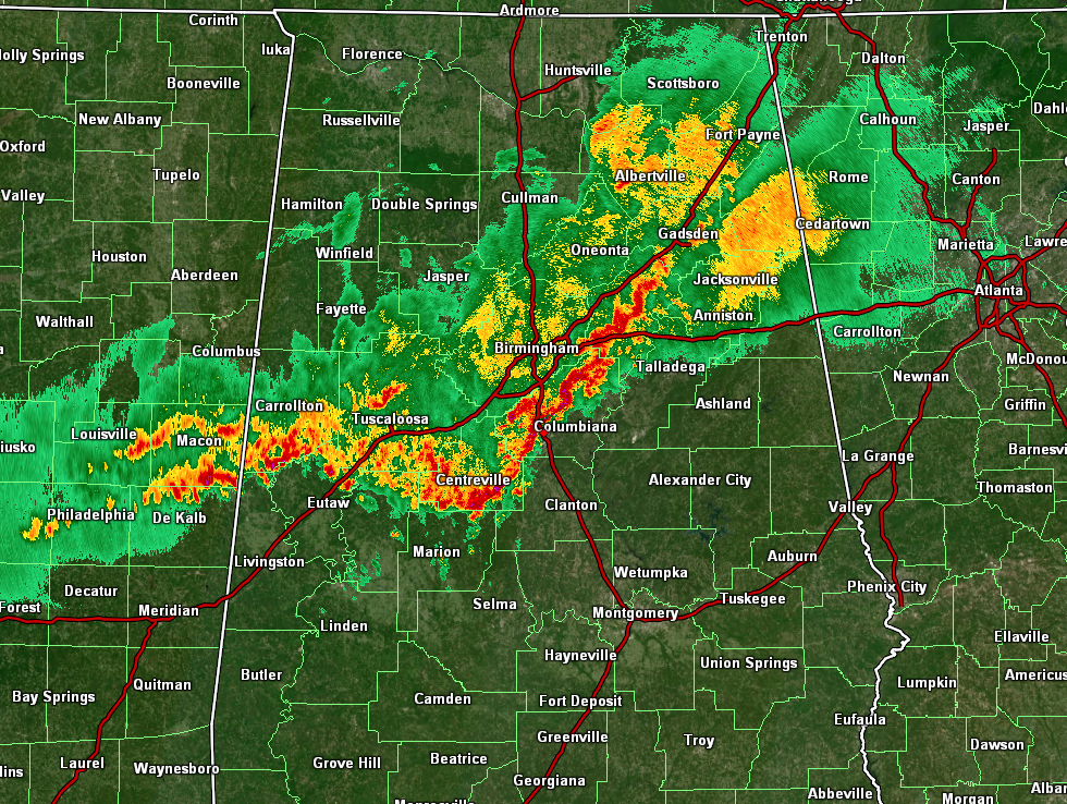
As of 10:15 am this morning, the main line of stronger thunderstorms has now pushed south and east of the I-59 corridor, which will now give an all-clear from the severe weather threat for locations north and west of I-59. However, the severe threat continues along and ahead of the line of storms, where there is a risk of damaging thunderstorm wind gusts up to 60 mph and a very small risk of a brief spin-up tornado. SPC just released its latest Mesoscale Discussion and still believes that a severe weather watch is not needed at this time.
Here is the latest Mesoscale Discussion from the SPC:
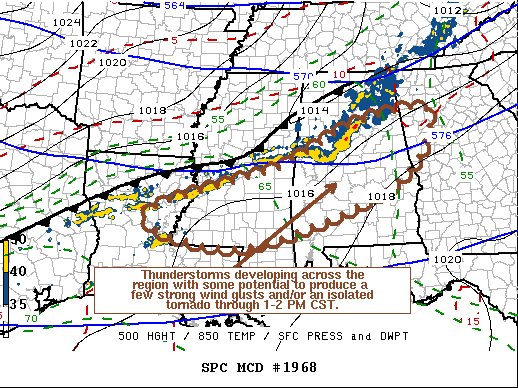
SUMMARY… Thunderstorm activity will continue to develop along and ahead of a southward advancing cold front through 1-2 PM CST, posing a risk for a few potentially damaging wind gusts and, perhaps, an isolated tornado or two. While the damaging wind/tornado risk appears low enough that a severe weather watch may not be needed, trends will continue to be monitored.
DISCUSSION… A mid-level speed maximum (50-60+ kt around 500 mb) might have contributed to organization of an evolving cluster of storms that is currently overspreading central Alabama. By 18-19Z, this jet streak is forecast to rapidly propagate east-northeastward, into and through the Georgia and South Carolina piedmont, where weak lower/mid-tropospheric lapse rates and slow/limited modification of generally stable boundary-layer conditions appear likely to preclude an appreciable risk for severe weather.
Models indicate that seasonably moist boundary-layer air will remain confined to along and ahead of the southward advancing cold front, across and east-northeast of the lower Mississippi Valley. Even here, weak lapse rates are limiting CAPE to 500-1000 J/kg or less. Given the lack of stronger potential instability, deep-layer wind fields and shear appear only marginally supportive of continuing organized strong thunderstorm development with the potential to produce a few damaging wind gusts and/or, perhaps, an isolated tornado. This is expected to remain generally focused within a corridor of stronger forcing immediately ahead of the front, advancing south of the Interstate 20 corridor through early afternoon, where low-level shear (beneath a 30-40 kt 850 jet axis) is also strongest.
Category: Alabama's Weather, ALL POSTS, Severe Weather
About the Author (Author Profile)
Scott Martin is an operational meteorologist, professional graphic artist, musician, husband, and father. Not only is Scott a member of the National Weather Association, but he is also the Central Alabama Chapter of the NWA president. Scott is also the co-founder of Racecast Weather, which provides forecasts for many racing series across the USA. He also supplies forecasts for the BassMaster Elite Series events including the BassMaster Classic.Subscribe
If you enjoyed this article, subscribe to receive more just like it.


