

Midday Nowcast: Warm, Muggy, A Few Showers
It is another warm and mainly cloudy day across Alabama and there have been a few showers on the radar today, but many locations remain dry.

Temperatures this afternoon will be in the 70s areawide, and there are likely some low 80s across South Alabama today. Tomorrow, the weather gets much more active with the first of two likely rounds of strong to severe storms that will threaten Alabama this week.
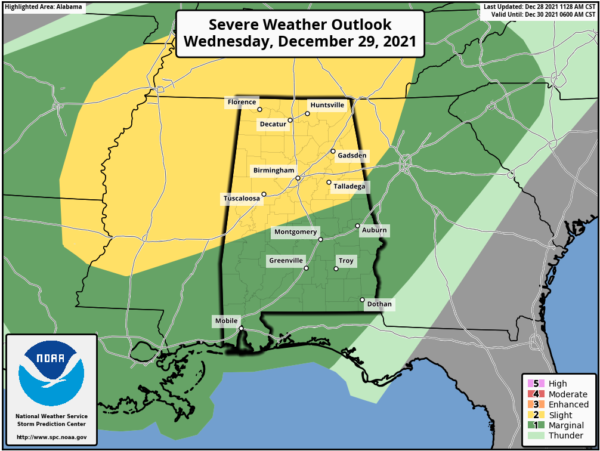
SEVERE STORMS ROUND ONE: The SPC maintains a “slight risk” (level 2/5) for areas north of a line from Demopolis to Verbena to Wedowee and a “marginal risk” (level 1/5) for the rest of the state south of that line.
There is ample instability in place across the state, and there should be moderate shear values, but with the main dynamics remaining to the north, this isn’t a classic severe weather setup for the state. However, there is a threat and we must take it seriously.
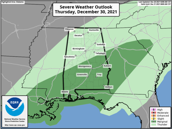
TIMING: The main window for severe storms will come from about 6PM Wednesday-9AM Thursday. On Thursday, the southern portions of Alabama remain in a “marginal risk.”
We are not expecting a line of storms, but more random, discrete cells, so we can’t give a specific times for anyone location.
THREATS: Strong thunderstorms will be capable of producing strong straight line winds and there could be some larger hail reports. A few isolated tornadoes are possible as well. For now flooding issues are not expected, but stronger storms will bring a heavy downpour.
CALL TO ACTION: It has been a while since we’ve had to deal with an organized threat for severe storms. Now is this time to prepare and review your severe weather safety plan. Be sure you have a way of hearing warnings if they are needed. NEVER an outdoor siren. The baseline is a NOAA Weather Radio (every home and business needs one!). Be sure emergency alerts are enabled on your phone, and download the free ABC 33/40 weather app. In your safe place be sure and have helmets for everyone, along with hard sole shoes and a portable airhorn.
For Thursday and Friday, it stays mild with highs in the low 70s, and showers will remain in the forecast both days, as we continue to see more clouds than sun.
SEVERE STORMS ROUND TWO: Another round of strong and/or severe storms is expected Saturday, Saturday night and early Sunday across Alabama.
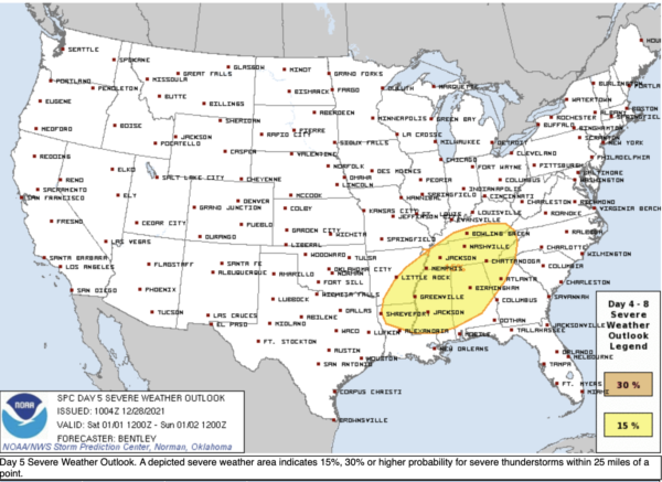
The SPC has defined a risk of severe thunderstorms for almost all of Alabama on New Year’s Day as a strong cold front will approach. This could bring a more significant severe thunderstorm threat to the state, with all modes of severe weather possible. But, this is five days out and it is too early to be specific. Let’s get through the midweek threat before we focus on the weekend threat.
BEACH FORECAST CENTER: Get the latest weather and rip current forecasts for the beaches from Fort Morgan to Panama City on our Beach Forecast Center page. There, you can select the forecast of the region that you are interested in visiting.
WORLD TEMPERATURE EXTREMES: Over the last 24 hours, the highest observation outside the U.S. was 115.3F at Port Headland Airport, Australia. The lowest observation was -71.3F at Delyankir, Russia.
CONTIGUOUS TEMPERATURE EXTREMES: Over the last 24 hours, the highest observation was 92F at Rio Grande Village, TX. The lowest observation was -30F at Havre, MT.
WEATHER ON THIS DATE IN 2003: A severe snow storm hit northern California and southern Oregon. As much as 2 feet of snow fell along Interstate 5 closing a 150-mile stretch of the interstate, stranding hundreds of travelers. Winds from the storm caused power outages to more than 200,000 customers in California and Oregon.
Category: Alabama's Weather, ALL POSTS
About the Author (Author Profile)
Macon, Georgia Television Chief Meteorologist, Birmingham native, and long time Contributor on AlabamaWX. Stormchaser. I did not choose Weather, it chose Me. College Football Fanatic. @Ryan_StinnetSubscribe
If you enjoyed this article, subscribe to receive more just like it.


