

Midday Nowcast: Wet with Falling Temperatures
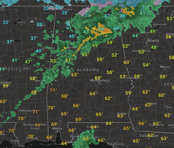
Rain has returned to Alabama today, and it will remain cloudy with the occasional showers. Temperatures this morning have been in the 40s and 50s, but will be falling through the 30s this afternoon as the front sinks south.
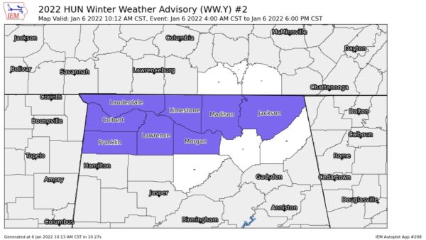
A winter weather advisory remains in effect for areas along and north of the Tennessee River through this evening. As temperatures fall over the northern quarter of the state, there is still potential for a chance of some sleet, freezing rain, and a few snow flakes later today. For most communities over the northern half of Alabama, south of the advisory, the precipitation will be long gone before we reach freezing.
COLD NIGHT & FRIDAY: As we head into tonight, we are in store for a very cold and windy night. As the sky clears tonight, temperatures will fall into the 17°-24° degree range early tomorrow morning. Factor in the wind and wind chill will be around 10° for much of Central Alabama. Tomorrow will remain cold despite sunshine in full supply, expect highs in the upper 30s to lower 40s.
THE ALABAMA WEEKEND: Saturday morning will be cold with lows back in the 20s, but the day will be sunny and warmer with highs back in the mid-50s. Clouds begin to increase Saturday night ahead of the next front that will bring rain and some storms back to Alabama on Sunday. Severe storms are not in the forecast and highs Sunday will be in the upper 50s to low 60s.
NEXT WEEK: On Monday it stays cold with highs in the 40s. Most of the week looks dry, although rain looks to return late Thursday or Friday as another cold front approaches. Temperatures next week look fairly seasonal with highs most days in the 50s, and lows in the 30s.
BEACH FORECAST CENTER: Get the latest weather and rip current forecasts for the beaches from Fort Morgan to Panama City on our Beach Forecast Center page. There, you can select the forecast of the region that you are interested in visiting.
WORLD TEMPERATURE EXTREMES: Over the last 24 hours, the highest observation outside the U.S. was 113.7F at Mount Magnet, Australia. The lowest observation was -67.0F at Sebyan-Kyuel’, Russia.
CONTIGUOUS TEMPERATURE EXTREMES: Over the last 24 hours, the highest observation was 87F at Falcon Lake, TX. The lowest observation was -23F at Hinsdale, MT.
WEATHER ON THIS DATE IN 1988: It was a bad day for chickens. Heavy snow in Arkansas, with totals ranging up to 16 inches at Heber Springs, claimed the lives of 3.5 million chickens, and snow and ice up to three inches thick claimed the lives of another 1.75 million chickens in north central Texas. Up to 18 inches of snow blanketed Oklahoma, with Oklahoma City reporting a record 12 inches of snow in 24 hours.
Category: Alabama's Weather, ALL POSTS
About the Author (Author Profile)
Macon, Georgia Television Chief Meteorologist, Birmingham native, and long time Contributor on AlabamaWX. Stormchaser. I did not choose Weather, it chose Me. College Football Fanatic. @Ryan_StinnetSubscribe
If you enjoyed this article, subscribe to receive more just like it.


