

Sunday Weather Xtreme Video: Severe Weather Possible Today
ON THE WEATHER MAPS
A strong upper-level ridge dominates the eastern half of the country this morning. A strong upper trough extends from Saskatchewan and Manitoba back down into the Rockies. At the surface, dual low-pressure centers are near Texarkana AR, and just north of Memphis. The upper trough will push east today and dig into the northeastern United States. That will allow a cold front to push through Alabama this afternoon and tonight. But before that, a surface warm front will push to the north across the state.
THE ALABAMA WEATHER PICTURE ON THIS SUNDAY MORNING
A band of showers is moving across the state this morning, ahead of the main rain and storms, which are back over eastern Arkansas and western Tennessee. Temperatures are in the lower 50s across much of the area with upper 40s over Northeast Alabama. Dewpoints that are now in the 50s will rise into the lower and middle 60s this afternoon behind the retreating warm front.
THE MAIN EVENT
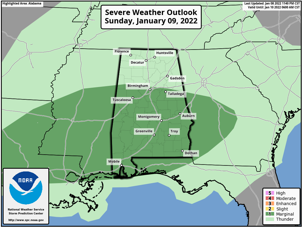
The line of storms will reach the northwestern corner of Alabama by 11 a.m. or so. By 3 p.m. it should be approaching Jasper, Cullman, and Fort Payne. Up until that time, the storms will not be surface-based, so they might be noisy, but should not be severe. Heavy rain and gusty winds will be a threat though. As they move into Central Alabama during the afternoon, reaching I-59 between 3-4 p.m., strong to severe storms will be possible, as instability values range from 100-300 joules/kg. This will produce a marginal risk of storms for areas south of a line from Reform in Pickens County to Calera in Shelby County to Roanoke in Randolph County. Once the storms get south of US-80 from Demopolis to Montgomery to Auburn, they will encounter better instability. There will be decent bulk shear for organized storms. There will also be enough helicity over the southern half of Central Alabama, introducing a small threat of tornadoes. Otherwise, the threats will be damaging winds and hail. The storms should push fairly quickly to the southeast, cutting down on the threat of any flooding, despite precipitable water values that are running one inch above normal. After 6 p.m. the storms should push out of Central and into Southeast Alabama.
TONIGHT
The cold front will reach I-59 by 6 p.m. All behind the front, temperatures will fall quickly through the 50s, and into the 40s not long behind that. Overnight lows will drop below freezing north of I-20, with middle 30s across the central part of the state. Skies will clear gradually this evening. There will be some patchy fog, but it will be limited by the slow clearing and the winds, which will stay up around 6-10 mph overnight.
NEXT WEEK
High pressure will build back quickly in the wake of the departing trough. Skies will become sunny on Monday, with highs in the mid-40s to the upper 50s across the area. More sunshine on Tuesday and still rather cool with highs reaching the mid-40s to the mid-50s. Same story on Wednesday, with slightly warmer temperatures, reaching the upper 40s to the mid-50s. And a little warmer on Thursday with a good bit of sunshine, as highs will be in the mid-50s to the lower 60s.
The next showers could arrive on Friday, at least according to the Euro, but the GFS keeps us dry until late Saturday. Showers and storms will be likely then, wit some light snow possible over the Tennessee Valley of North Alabama as the system departs late Saturday night into Sunday morning.
ON THIS DAY IN WEATHER HISTORY
1980 — Very high winds in response to one of the strongest non-tropical cyclones in history struck Oregon. The roof of the state house in Salem was damaged. Barometer at Portland dropped to a record 28.50″.
BEACH FORECAST
Get the latest weather and rip current forecasts for the beaches from Dauphin Island, AL, to Panama City Beach, FL, on our Beach Forecast Center page. There, you can select the forecast of the region that you are interested in.
ADVERTISE ON THE BLOG
We had a record-breaking year in 2020 with over 20 million page views! We are on a record-shattering pace to break that mark, as we are already over 17.4 million page views through the first half of 2021! Don’t miss out! We can customize a creative, flexible, and affordable package that will suit your organization’s needs. Contact Bill Murray at (205) 687-0782.
E-FORECAST SIGN UP
Get the Alabama Weather Blog’s Seven-Day Forecast delivered directly to your inbox by email twice daily. It is the most detailed weather forecast available in Central Alabama. Subscribe here… It’s free!
CONNECT WITH THE BLOG ON SOCIAL MEDIA
You can find the AlabamaWx Weather Blog on Facebook and Twitter.
WEATHERBRAINS
This week’s show will be recorded Tuesday evening. The guest is still to be determined. This week watch live starting at 7:00 pm CT on Tuesday night at live.bigbrainsmedia.com or live on James Spann’s YouTube channel. Of course, the show is usually on Monday nights. Listeners can find the recorded audio versions at WeatherBrains.com or on your favorite podcast platform (Apple Podcasts, Stitcher, Spotify, etc.).
Category: Alabama's Weather, ALL POSTS, Severe Weather
About the Author (Author Profile)
Bill Murray is the President of The Weather Factory. He is the site's official weather historian and a weekend forecaster. He also anchors the site's severe weather coverage. Bill Murray is the proud holder of National Weather Association Digital Seal #0001 @wxhistorianSubscribe
If you enjoyed this article, subscribe to receive more just like it.


