

Sunny Day Ahead With A Nice Warm-Up
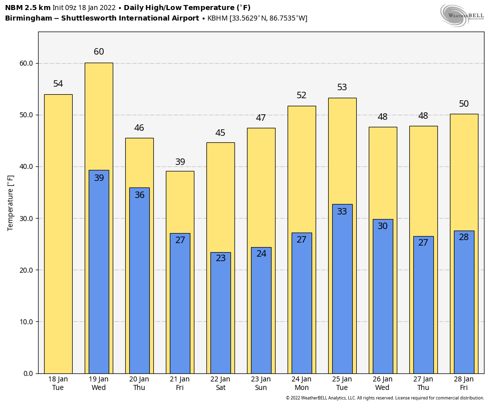
COLD START: Temperatures are mostly in the 22-28 degree range across Alabama early this morning… but we expect a nice warm-up today with a good supply of sunshine. Most communities will reach the mid 50s this afternoon, right at seasonal averages for mid-January. Tonight will be mostly fair and not as cold as last night with a low between 35 and 42.
The sky becomes cloudy tomorrow, and rain will enter Northwest Alabama late in the day ahead of a cold front. Rain should be widespread tomorrow night over the northern half of the state. Some thunder is possible, but severe storms are not expected here (SPC does maintain a “marginal risk” to the west over parts of Mississippi, Louisiana, Arkansas, and Texas).
The forecast gets complex Thursday and Friday; let’s take it chronological order.
THURSDAY: Much colder air will roll into North Alabama early Thursday, with temperatures going below freezing. There is a chance there could be some overlap between the sub-freezing air and the back edge of the precipitation associated with the cold front. Meaning, there could be a window for a little freezing rain, freezing drizzle, or sleet over parts of North Alabama Thursday morning. This in turn could bring some potential for bridge icing north of Birmingham. Generally speaking this is a marginal threat, and there is a chance the precipitation will end by the time temperatures go below freezing. Just be aware of the potential if you are in North Alabama Thursday morning.
Rain will continue over South Alabama during the day Thursday as the front pushes southward. Temperatures will hold in the 30s all day Thursday over the northern half of the state, and a few spots over the Tennessee Valley will struggle to get above freezing.
FRIDAY: A wave of low pressure is expected to form on the front in the northern Gulf of Mexico, and more precipitation will spread northward across Alabama. There is a chance this could begin in the form of freezing rain for parts of North Alabama Friday morning, where temperatures will be below freezing.
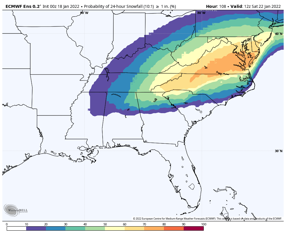
Then, later in the day, precipitation is possible in the form of light snow over the northeast counties of the state Friday afternoon and Friday night, in the colder air. Model output remains inconsistent, and forecast confidence remains low. Using the ensemble approach, the European global model shows the chance of 1 inch of snow or greater across Northeast Alabama Friday/Friday night in the 30-50 percent range, while the American global model is at 20 percent or less.
Bottom line is that it is still too early for a specific forecast, but just be aware some winter weather impact is possible Friday and Friday night over parts of North or Northeast Alabama. We will have much better clarity over the next 24 hours.
THE ALABAMA WEEKEND: Saturday will be cold and dry with a clearing sky; the high will be in the mid 40s. Sunday will be a mostly sunny day with a high between 48 and 52.
NEXT WEEK: Temperatures will likely remain below average through the week; new model data suggests some rain will be possible Tuesday… especially over the southern half of the state. See the Weather Xtreme video for maps, graphics, and more details.
ON THIS DATE IN 1971: A warm Santa Ana condition brought a 95 degree reading to Los Angeles, the highest January temperature on record. It was 95 degrees in Palm Springs, the highest temperature on record for January as well.
ON THIS DATE IN 1973: The first tornado death of the year has been registered north of Corey, Louisiana, during the afternoon hours. Although a girl was killed when a tenant farm was destroyed, a baby received only minor injuries when it was carried 300 to 400 yards by the tornado.
BEACH FORECAST: Click here to see the AlabamaWx Beach Forecast Center page.
WEATHER BRAINS: Don’t forget you can listen to our weekly 90 minute show anytime on your favorite podcast app. This is the show all about weather featuring many familiar voices, including our meteorologists here at ABC 33/40.
CONNECT: You can find me on all of the major social networks…
Look for the next Weather Xtreme video here by 3:00 this afternoon… enjoy the day!
Category: Alabama's Weather, ALL POSTS, Weather Xtreme Videos
About the Author (Author Profile)
James Spann is one of the most recognized and trusted television meteorologists in the industry. He holds the AMS CCM designation and television seals from the AMS and NWA. He is a past winner of the Broadcast Meteorologist of the Year from both professional organizations.Subscribe
If you enjoyed this article, subscribe to receive more just like it.


