

Mesoscale Discussion — Watch Coming Soon for South & Southwestern Parts of the Area
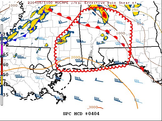
SUMMARY… A tornado risk may develop later this morning from southern Mississippi into Alabama and parts of the Florida panhandle.
DISCUSSION… A warm front continues to push rapidly north, with upper 60s to lower 70s F dewpoints now common. Stronger elevated cells producing hail have been evident at times, but mostly isolated.
Effective SRH of 300-400 m2/s2 is common across the warm sector, with higher values near the warm front. The air mass is uncapped, although low-level lapse rates remain poor. However, any cells ahead of the advancing squall line over central MS may acquire rotation.
Probability of Watch Issuance… 80 percent
Category: Alabama's Weather, ALL POSTS, Severe Weather
About the Author (Author Profile)
Scott Martin is an operational meteorologist, professional graphic artist, musician, husband, and father. Not only is Scott a member of the National Weather Association, but he is also the Central Alabama Chapter of the NWA president. Scott is also the co-founder of Racecast Weather, which provides forecasts for many racing series across the USA. He also supplies forecasts for the BassMaster Elite Series events including the BassMaster Classic.Subscribe
If you enjoyed this article, subscribe to receive more just like it.


