

Midday Nowcast: Muggy with Rain and Storms
Today through Thursday we continue to have a very warm and muggy air mass in place across the state. We are seeing more clouds than sun with temperatures ranging from the mid 70s to mid 80s. It doesn’t take much to get showers and storms to develop and we are seeing those again today. We tend to see an uptick in the activity as we roll through the afternoon and evening hours due to the higher instability values. A check on the radar shows a mass of rain and storms across West and Central Alabama, these are producing heavy downpours.

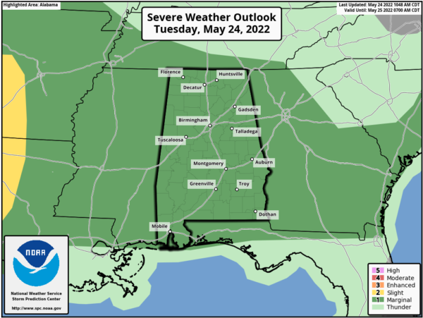
We will monitor these these for a locally severe potential and the SPC maintains a “marginal risk” (level 1/5) of severe thunderstorms for all of Alabama the rest of today for the potential of some storms to produce hail and gusty winds.
For tomorrow and Thursday rain and storms will become more numerous as a front and upper trough approach the area. The potential for hail and gusty winds will persist with heavier thunderstorms and the SPC has areas from Birmingham north and west in a “marginal risk” tomorrow, and nearly all of Alabama in a “marginal risk” Thursday. There will be some shear involved Thursday, so the chance of a tornado is not zero, but still very low. Rainfall totals the next 48 hours will be in the 1-3 inch range statewide. The rain will end at some point Thursday night as the front swings through the state.
FRIDAY AND THE HOLIDAY WEEKEND: Dry air will work into the state late Thursday night, and Friday will be a mostly sunny day with a high close to 80 degrees. Then, we expect delightful weather for the three day holiday weekend with sunny days, fair nights, and highs in the 80s. Nights will be refreshing with widespread 50s possible. Monday should be the hottest of the weekend with highs close to 90°.
REST OF NEXT WEEK: An upper ridge will build across the Gulf Coast region, meaning mostly hot and dry weather with highs in the low 90s. However, a few spotty showers could show up late in the week.
BEACH FORECAST CENTER: Get the latest weather and rip current forecasts for the beaches from Fort Morgan to Panama City on our Beach Forecast Center page. There, you can select the forecast of the region that you are interested in visiting.
WORLD TEMPERATURE EXTREMES: Over the last 24 hours, the highest observation outside the U.S. was 118.4F at Dammam, Saudi Arabia. The lowest observation was -100.5F at Vostok, Antarctica.
CONTIGUOUS TEMPERATURE EXTREMES: Over the last 24 hours, the highest observation was 104F at Death Valley, CA. The lowest observation was 17F at Vernal, VT.
Category: Alabama's Weather, ALL POSTS
About the Author (Author Profile)
Macon, Georgia Television Chief Meteorologist, Birmingham native, and long time Contributor on AlabamaWX. Stormchaser. I did not choose Weather, it chose Me. College Football Fanatic. @Ryan_StinnetSubscribe
If you enjoyed this article, subscribe to receive more just like it.


