

Mesoscale Discussion: Watch Unlikely At This Point as Severe Potential Remains Limited
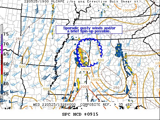
Mesoscale Discussion 0915
NWS Storm Prediction Center Norman OK
0234 PM CDT Wed May 25 2022
Areas affected…northeast MS into northwest AL
Concerning…Severe potential…Watch unlikely
Valid 251934Z – 252100Z
Probability of Watch Issuance…20 percent
SUMMARY…Gusty winds and a brief spin-up could occur with
convection over the next few hours. However, overall severe
potential is expected to remain limited.
DISCUSSION…A line of convection will continue to shift
east/northeast across northeast MS and northwest AL the next few
hours. This area has destabilized less than areas to the south as
cloud cover has persisted much of the day. Modest effective shear
and poor low and midlevel lapse rates amid weak instability will
limit overall severe potential. While the KGWX VWP does show
somewhat enlarged and favorably curved low-level hodographs, 0-3 km
MLCAPE is fairly weak ahead of the line of convection. Some broad
rotation has occasionally been noted, but weak low-level winds and
modest low-level instability should also limit tornado potential.
Overall, convection has not produced measured severe gusts through
the day, with only minor wind damage reports received. Given the
less favorable downstream environment, severe potential is expected
to remain limited and a watch is not anticipated.
Category: Alabama's Weather, ALL POSTS, Severe Weather
About the Author (Author Profile)
Scott Martin is an operational meteorologist, professional graphic artist, musician, husband, and father. Not only is Scott a member of the National Weather Association, but he is also the Central Alabama Chapter of the NWA president. Scott is also the co-founder of Racecast Weather, which provides forecasts for many racing series across the USA. He also supplies forecasts for the BassMaster Elite Series events including the BassMaster Classic.Subscribe
If you enjoyed this article, subscribe to receive more just like it.


