

EXPIRED Flash Flood Warning: Parts of Colbert, Franklin Co. Until 9:15 pm
The National Weather Service in Huntsville has extended the
* Flash Flood Warning for…
Southern Colbert County in northwestern Alabama…
Northern Franklin AL County in northwestern Alabama…
* Until 915 PM CDT.
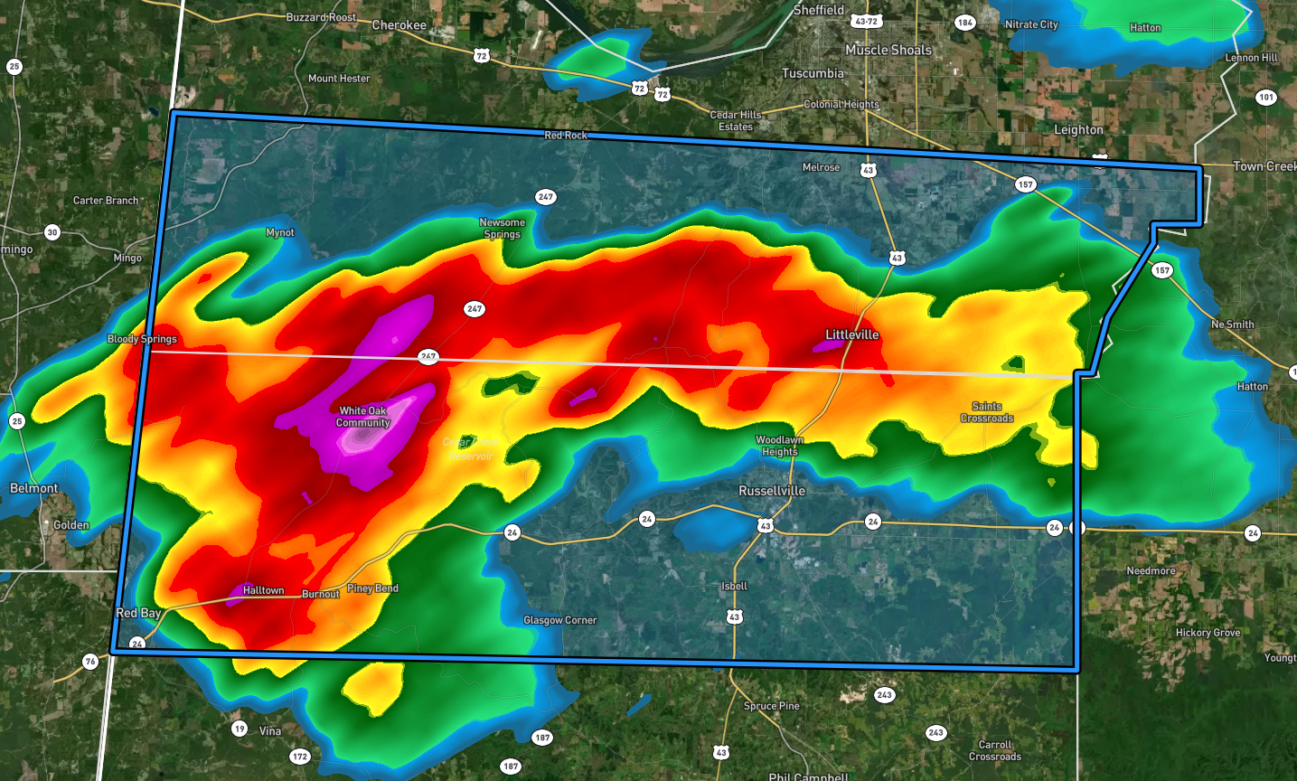
* At 726 PM CDT, Doppler radar indicated that earlier thunderstorms
produced heavy rain across the warned area over extremely
saturated soils. Between 2 and 4 inches of rain has fallen.
Additional rainfall amounts of 0.5 to 1 inch are possible in the
warned area as additional showers and storms push in. Flash
flooding is ongoing or expected to begin shortly.
HAZARD…Flash flooding caused by thunderstorms.
SOURCE…Radar.
IMPACT…Flash flooding of small creeks and streams, urban
areas, highways, streets and underpasses as well as
other poor drainage and low-lying areas.
* Some locations that will experience flash flooding include…
Russellville, Red Bay, Littleville, Belgreen, Crooked Oak, New
Bethel, Cedar Creek Reservoir, Srygley Church, Rockwood, Posey
Loop, Isbell, Dempsey, Red Rock, Little Bear Creek Reservoir,
Colbert Heights, Tharptown, Pleasant Site, Mynot, Halltown and
Newburg.
PRECAUTIONARY/PREPAREDNESS ACTIONS…
Turn around, don’t drown when encountering flooded roads. Most flood
deaths occur in vehicles.
Be aware of your surroundings and do not drive on flooded roads.
The National Weather Service in Huntsville has issued a
* Flash Flood Warning for…
Southern Colbert County in northwestern Alabama…
Northern Franklin AL County in northwestern Alabama…
* Until 745 PM CDT.
* At 439 PM CDT, Doppler radar indicated thunderstorms producing
heavy rain across the warned area. Between 1 and 2 inches of rain
have fallen over an already saturated ground. Additional rainfall
amounts of 1 to 3 inches are possible in the warned area. Flash
flooding is ongoing or expected to begin shortly.
HAZARD…Flash flooding caused by thunderstorms.
SOURCE…Radar.
IMPACT…Flash flooding of small creeks and streams, urban
areas, highways, streets and underpasses as well as
other poor drainage and low-lying areas.
* Some locations that will experience flash flooding include…
Russellville, Red Bay, Littleville, Belgreen, Crooked Oak, New
Bethel, Cedar Creek Reservoir, Srygley Church, Rockwood, Posey
Loop, Isbell, Dempsey, Red Rock, Little Bear Creek Reservoir,
Colbert Heights, Tharptown, Pleasant Site, Mynot, Halltown and
Newburg.
PRECAUTIONARY/PREPAREDNESS ACTIONS…
Turn around, don’t drown when encountering flooded roads. Most flood
deaths occur in vehicles.
In hilly terrain there are hundreds of low water crossings which are
potentially dangerous in heavy rain. Do not attempt to cross flooded
roads. Find an alternate route.
Category: Alabama's Weather, ALL POSTS
About the Author (Author Profile)
Scott Martin is an operational meteorologist, professional graphic artist, musician, husband, and father. Not only is Scott a member of the National Weather Association, but he is also the Central Alabama Chapter of the NWA president. Scott is also the co-founder of Racecast Weather, which provides forecasts for many racing series across the USA. He also supplies forecasts for the BassMaster Elite Series events including the BassMaster Classic.Subscribe
If you enjoyed this article, subscribe to receive more just like it.


