

A Severe Thunderstorm Watch May Be Issued Over the Next Couple of Hours
From the Storm Prediction Center.
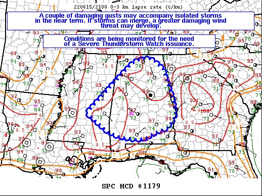
SUMMARY… A couple damaging gusts are possible with ongoing isolated
storms over the next couple of hours. A more concentrated risk of
damaging gusts may materialize if storms can merge into a line later
this evening. Conditions are being monitored for the need of a
Severe Thunderstorm Watch issuance pending storm mergers.
DISCUSSION… Isolated pulse-cellular storms have recently matured
across eastern MS into AL over the last couple of hours per latest
MRMS mosaic radar imagery. One pulse storm along the Dallas/Lowndes
County, AL line has exhibited near 1.5 inch diameter via the MRMS
MESH algorithm, with a 55 kt gust, recently observed per KSEM ASOS.
Though deep-layer shear is weak, the ongoing storms are thriving in
a 3000+ J/kg MLCAPE environment, driven by 70+F surface dewpoints
and near 100F surface temperatures. 20Z RAP forecast soundings
(valid for 22Z) shows a well-mixed boundary layer, with 21Z
mesoanalysis depicting 8.5 C/km 0-3 km lapse rates. As such, the
more intense storm cores may experience enough evaporative cooling
to support damaging gusts. Given modest mid-level lapse rates, an
instance of 1+ inch hail cannot be ruled out.
At the moment, the severe threat is expected to be sparse given the
isolated nature of the storms. However, should storms cluster and
form a loosely organized MCS structure later this evening, the
damaging gust threat could become more prevalent. As such,
conditions will continue to be monitored for the need of a Severe
Thunderstorm Watch issuance pending MCS development.
Category: Alabama's Weather, ALL POSTS, Severe Weather
About the Author (Author Profile)
Scott Martin is an operational meteorologist, professional graphic artist, musician, husband, and father. Not only is Scott a member of the National Weather Association, but he is also the Central Alabama Chapter of the NWA president. Scott is also the co-founder of Racecast Weather, which provides forecasts for many racing series across the USA. He also supplies forecasts for the BassMaster Elite Series events including the BassMaster Classic.Subscribe
If you enjoyed this article, subscribe to receive more just like it.


