

Midday Nowcast: Sun, Heat, Storms
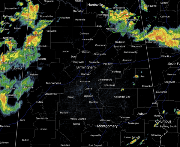
Scattered showers and thunderstorms have been ongoing this morning and continue across the Alabama landscape as we roll through the midday hours and into the afternoon hours. Stronger storms are producing heavy rain, strong gusty winds, lots of lightning, loud thunder. The SPC has introduced a “marginal risk” (level 1/5) for a few storm across East Alabama today.
It won’t rain everywhere, but some spots will see a good “summer soaker” today, and there could be areas of flash flooding. Where it is not raining, we are seeing a mix of sun and clouds with highs in the low 90s.
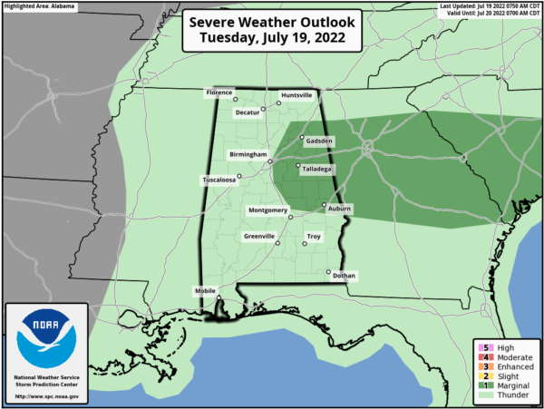
DRIER AND HOT TOMORROW: Rain chances look to be lower tomorrow, but still there will be some showers and storms on the radar, especially across eastern portions of the state. Tomorrow looks to be hot with many locations approaching the mid-90s, and I would not be surprised to see some locations in Central Alabama get a Heat Advisory tomorrow as heat index values approach 105°.
STORMY THURSDAY: A weak surface front will approach from the north Thursday, setting the stage for a very active day of rain and storms with the potential for strong to severe thunderstorms.
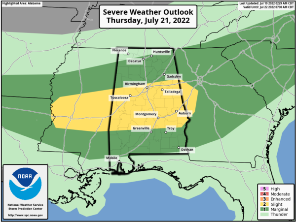
The SPC has already defined a “slight risk” (level 2/5) for the central counties of Alabama, and a “marginal risk” (level 1/5) for most of the rest of the state. The main concern with this risk Thursday is from wet microbursts, local areas of strong winds with potential for some tree and power line damage. Highs will be mostly in the low 90s.
FRIDAY AND THE WEEKEND: The boundary should push into South Alabama Friday, keeping rain and storms in the forecast down that way and along the Gulf Coast. Unfortunately, the upper ridge to the west, will build east into the Deep South, meaning higher heat levels and fewer showers and storms. Highs will be mostly in the mid 90s over the weekend.with potential for upper 90s in spots.
NEXT WEEK: The upper ridge remains parked over the Deep South, meaning hot, humid days with highs mostly in the mid to upper 90s. Showers and storms are possible during the afternoon and evening hours, but they should be widely separated.
THE TROPICS: The Atlantic Basin is quiet for now with no signs of development through this weekend. The season is certainly going to become more active the deeper into the season we get. The next few names up are Danielle, Earl, and Fiona.
BEACH FORECAST CENTER: Get the latest weather and rip current forecasts for the beaches from Fort Morgan to Panama City on our Beach Forecast Center page. There, you can select the forecast of the region that you are interested in visiting.
WORLD TEMPERATURE EXTREMES: Over the last 24 hours, the highest observation outside the U.S. was 124.2F at Jarha, Kuwait. The lowest observation was -105.9F at Dome Ca, Antarctica.
CONTIGUOUS TEMPERATURE EXTREMES: Over the last 24 hours, the highest observation was 119F at Death Valley, CA. The lowest observation was 24F at Mackay, ID.
Category: Alabama's Weather, ALL POSTS
About the Author (Author Profile)
Macon, Georgia Television Chief Meteorologist, Birmingham native, and long time Contributor on AlabamaWX. Stormchaser. I did not choose Weather, it chose Me. College Football Fanatic. @Ryan_StinnetSubscribe
If you enjoyed this article, subscribe to receive more just like it.


