

EXPIRED Severe T-Storm Warning — Parts of Autauga, Dallas, Elmore, Perry, Tallapoosa Co. Until 8 pm
The National Weather Service in Birmingham has issued a
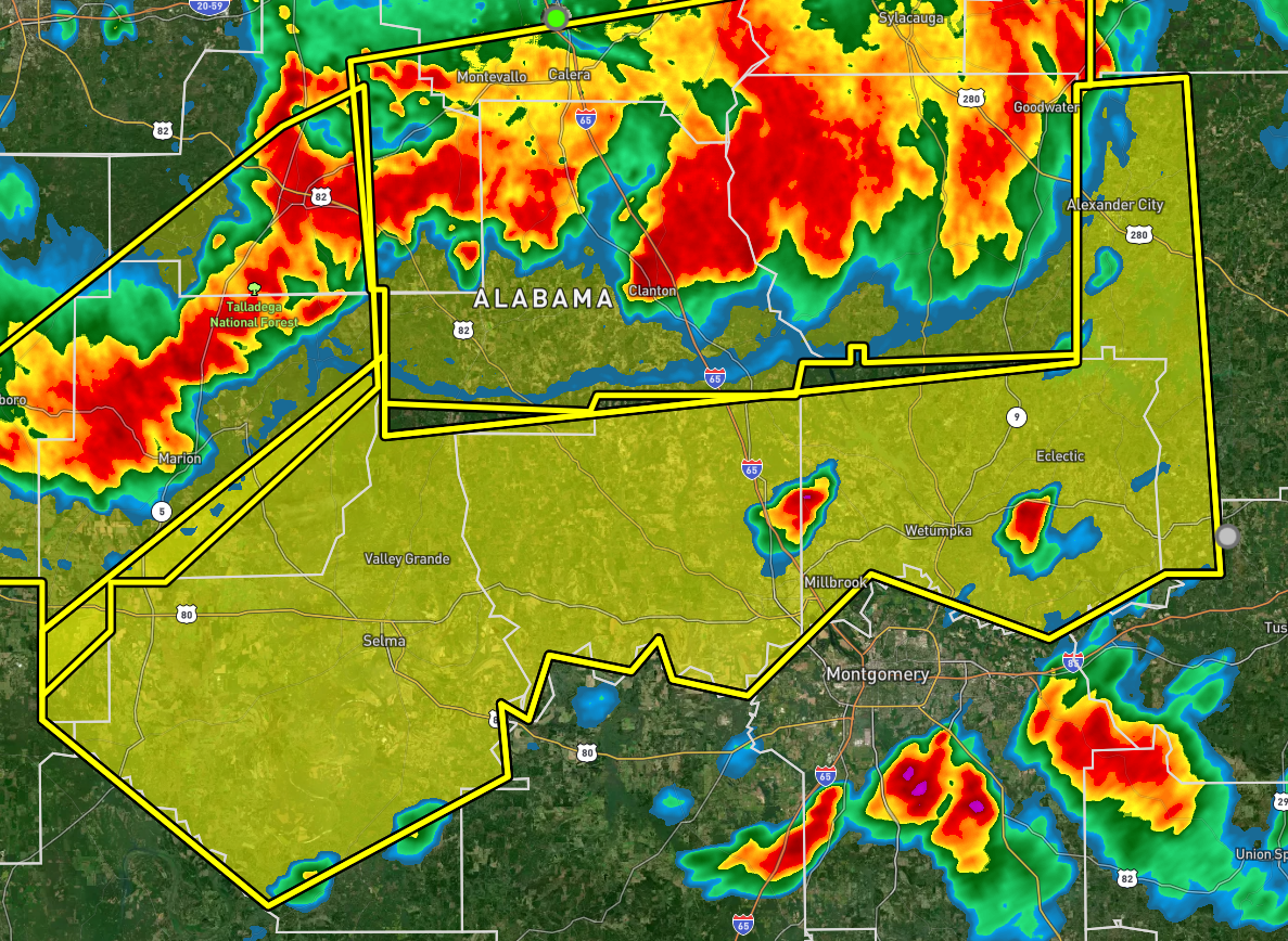
* Severe Thunderstorm Warning for…
Autauga County in central Alabama…
Elmore County in east central Alabama…
Central Perry County in central Alabama…
Dallas County in south central Alabama…
Western Tallapoosa County in east central Alabama…
* Until 800 PM CDT.
* At 652 PM CDT, severe thunderstorms were located along a line
extending from 8 miles west of Goldville to near Pentonville to
near Talladega National Forest to near Newbern, moving south at 45
mph.
HAZARD…60 mph wind gusts and penny size hail.
SOURCE…Radar indicated.
IMPACT…Expect damage to roofs, siding, and trees.
* Locations impacted include…
Prattville, Selma, Alexander City, Millbrook, Wetumpka, Tallassee,
Valley Grande, Selmont-West Selmont, Elmore, Coosada, Deatsville,
Eclectic, Autaugaville, Jacksons’ Gap, Orrville, Billingsley,
Martin Dam, Bogue Chitto, Santuck and Vaiden.
PRECAUTIONARY/PREPAREDNESS ACTIONS…
For your protection move to an interior room on the lowest floor of a
building.
Category: Alabama's Weather, ALL POSTS, Severe Weather
About the Author (Author Profile)
Scott Martin is an operational meteorologist, professional graphic artist, musician, husband, and father. Not only is Scott a member of the National Weather Association, but he is also the Central Alabama Chapter of the NWA president. Scott is also the co-founder of Racecast Weather, which provides forecasts for many racing series across the USA. He also supplies forecasts for the BassMaster Elite Series events including the BassMaster Classic.Subscribe
If you enjoyed this article, subscribe to receive more just like it.


