

Sunday Weather Video: More of the Same
HIGH PRESSURE: Alabama continues under a weak ridge of high pressure, which normally would act to suppress storms, but moisture levels across Alabama are very tropical and storms have no lack of fuel to get going. Keeping going is their problem, however, as is often the case during the summer, as wind shear is nearly zero across Alabama.
MORE OF THE SAME: Expect more of the same for your Sunday. At some point, the little pinwheel to the west should give out, but the moisture will still be in great supply, and so will a strong July Alabama sun. Afternoon highs today will be between 91-94F for the most part. Scattered showers and storms will once again form in the humid air, and watch out for them as they often are accompanied by lots of dangerous lightning.
ON THE WEATHER MAPS: That weak ridge across Alabama should hold through midweek, even as a big upper low begins to build over Midwest. The southward bulging of this low will actually serve to build our ridge a bit Tuesday and Wednesday, lessening those daily doses of showers and storms. And the heat will take advantage, with highs edging into the middle 90s and heat indices approaching 105-110 at times. Expect another round of heat advisories.
SOME LATE WEEK RELIEF: Of course, that bigger upper low will be trying to throw its weight around and push a front our way late in the week. That should be close enough by late Thursday to allow rain chances to start ramping up. Friday and especially Friday night looks wet for now, with numerous showers and storms. That continues into Saturday. This may allow for highs to stay in the 80s Friday and Saturday. You’re welcome!
WEEK AFTER: It looks like that boundary might continue to play a role in Alabama’s weather into the following week, with higher than normal rain chances.
DROUGHTWATCH: Areas northwest of I-59 are the driest across Alabama over the past 90 days. Areas to the southeast are generally in good shape, but the northwestern part of the state could really use some rain.
VOODOO COUNTRY: The typical, warm and humid, with scattered mainly afternoon and evening showers and storms. We haven’t found a better way to say it in 50 years…
BEACHCAST: Showers and thunderstorms will be a part of the forecast over the next week along the beautiful beaches of Alabama and Northwest Florida as a deep southeasterly flow brings plenty of moisture into the region each day for the powerful summer sun to work on. Highs will be hot, in the lower 90s. Lows will be in the upper 70s. Heat index values will be in the lower 100 degree range. Water temperatures are in the middle 80s. The rip current risk will be low this week.
Click here to see the Beach Forecast Center page.
NATIONALLY: Heat continues to be the main story nationally, with the Pacific Northwest now getting in on the act. Excessive Heat Watches have been issued for much of next week for parts of Washington, Oregon, and northern California. Much of the middle of the country and the Northeast is in the same boat, with a carpet of heat advisories with some excessive heat warnings in effect. The monsoon over the desert southwest has become active, with flash flood watches in effect for parts of Arizona, New Mexico, and Colorado.
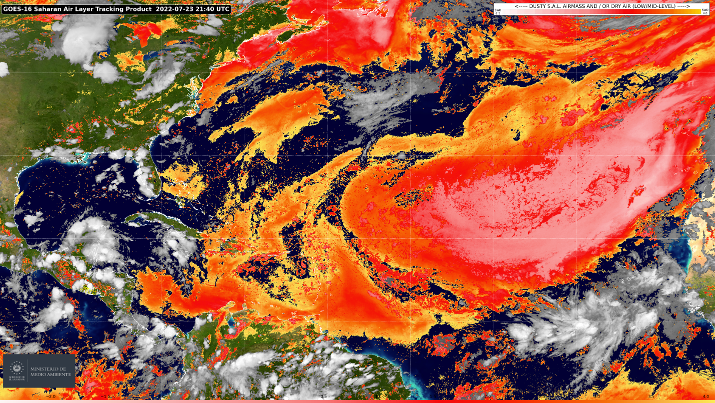
TOPIC: TROPICS: The Atlantic remains quiet. Several things are working against tropical development right now. First, the Saharan Air Layer (SAL) is very pronounced across much of the Main Development Region of the Atlantic. This dry air off the African continent robs potential tropical cyclones of their moisture, which is critical for their development. The stronger winds that transport the dust impart wind shear, which tropical cyclones hate. And finally, the brown dust absorbs heat in the air layer, warming it and making it more stable, again less conducive to the thunderstorms that tropical cyclones need. So the SAL is working against development. Second is the MJO. The tropical Atlantic is in the suppressed convective phase now, but that will be changing toward the end of the month and into early August. This area of enhanced clouds, rain, and storms will enhance convective activity and enhance the chance of tropical cyclones developing. Lastly, while sea surface temperatures are above normal in the Gulf and Caribbean, colder water has moved southward over the Main Development Region of the Atlantic in recent days. This has happened because of the powerful Bermuda-Azores high that dominates the Atlantic is pushing water southwestward. It is indeed one of the most dominant of the semi-permanent highs in my recollected memory. It is also responsible for the SAL dust, since a strong wind max has formed in the pressure gradient between the powerful high and low pressure over Africa. There are some signs that the B-A high is relenting a bit, allowing for warming of the eastern Atlantic waters. That will be good news if it does weaken, because right now, any hurricane that develops is going to be steered into the Caribbean or the eastern United States. A lot of yapping to say that the Atlantic is quiet, but should become busier in a couple of weeks. Stay tuned.
SIDEWALK: I don’t know about you, but I am already excited about filling out my dance card of films I want to see at our World-Class Film Festival August 22-28 at various venues in downtown Birmingham. It is easily the best lineup I remember. Perhaps all the great films that were dreamed up during COVID are being released now. Go to sidewalkfest.com to get your tickets now!
WEATHER NOTEBOOK: The tragic loss of two small children in West Birmingham in Thursday’s powerful severe thunderstorm as a tree fell on the home they were in is another reminder of the danger that thunderstorms pose. This thunderstorm was really remarkable for a summer storm, with large hail and very high winds. I was even noticing velocity readings of over 100 mph as the storm pushed south across southern Jefferson County. Just a reminder than severe thunderstorm warnings, like the excellent ones issued by the NWS Birmingham in this case. WE will be discussing the topic of whether there are too many severe thunderstorm warnings on WeatherBrains this coming Thursday evening.
ADVERTISE WITH US: Deliver your message to a highly engaged audience by advertising on the AlabamaWX.com website. The site enjoyed over 29 MILLION page views in the past 12 months. Don’t miss out! We can customize a creative, flexible, and affordable package that will suit your organization’s needs. Contact me, Bill Murray, at (205) 687-0782 and let’s talk.
WEATHERBRAINS: This week, the panel will entertain Tim Heller on Monday evening. He is a brilliant television weather mind. We will also talk about the Pacific Northwest Heat Wave of 2021 and the recent report concerning it with Cliff Mass, another brilliant WeatherBrain from the University of Washington. Check out the show at www.WeatherBrains.com. You can also subscribe on iTunes. You can watch the show live at live.bigbrainsmedia.com or on James’ YouTube Channel You will be able to see the show on the James Spann 24×7 weather channel on cable or directly over the air on the dot 2 feed.
ON THIS DATE IN 1952: Alabama was in the midst of one of its worst heat waves and droughts. Read a little about the event in a special weather history post on the blog today. Follow my weather history tweets on Twitter. I am @wxhistorian at Twitter.com.
Category: Alabama's Weather, ALL POSTS, Tropical
About the Author (Author Profile)
Bill Murray is the President of The Weather Factory. He is the site's official weather historian and a weekend forecaster. He also anchors the site's severe weather coverage. Bill Murray is the proud holder of National Weather Association Digital Seal #0001 @wxhistorianSubscribe
If you enjoyed this article, subscribe to receive more just like it.


