

Midday Nowcast: Quiet for Now, but Rain and Storms Return this Afternoon
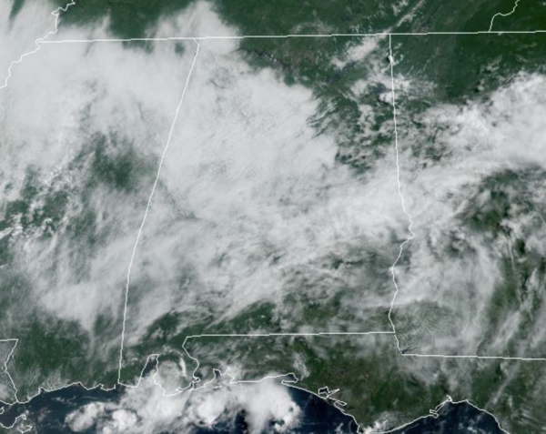
Another day of watching the radar as scattered showers and storms are in the forecast, with more numerous and widespread coverage across South Alabama as the sea breeze front remains very active this week. At the writing of this forecast, late morning, the radar is relatively quiet, but like the past few days, as daytime heating increases, so will instability, fueling those scattered to numerous showers and and storms to develop. Any storm will produce tropical downpours and a lot of lightning.

Where it doesn’t rain, expect very warm and muggy conditions with highs ranging from the mid 80s to low 90s. For Thursday, expect more of the same across North and Central Alabama. Rain chances today and tomorrow will range from 40-60% for most locations, with higher chances to the south.
FRIDAY AND THE WEEKEND: Rain chances decrease for Friday and Saturday with only isolated showers and storms expected during the afternoon and evening hours. Rain chances these two days are around 30%. However, rain chances will increase Sunday, closer to 50% as scattered showers and storms return to the forecast. Expect highs this weekend in the low to mid 90s.
THE TROPICS: The Atlantic Basin remains quiet…for now. No signs of tropical development this week, but activity should begin to increase in the coming weeks as we enter the peak of the season…late August, September, and early October. Next few names are Danielle, Earl, and Fiona.
NEXT WEEK: Above average rain chances will remain the forecast for the first few days next week. It will remain hot, very humid, with scattered to numerous showers and storms each day, mainly during the afternoon and evening hours. Highs next week will be in the low 90s, pretty close to normal values for mid-August.
BEACH FORECAST CENTER: Get the latest weather and rip current forecasts for the beaches from Fort Morgan to Panama City on our Beach Forecast Center page. There, you can select the forecast of the region that you are interested in visiting.
WORLD TEMPERATURE EXTREMES: Over the last 24 hours, the highest observation outside the U.S. was 124.5F at Ainaltamer, Iraq. The lowest observation was -81.4F at Dome C, Antarctica.
CONTIGUOUS TEMPERATURE EXTREMES: Over the last 24 hours, the highest observation was 115F at Death Valley, CA. The lowest observation was 33F at White Sulphur Springs, MT.
Category: Alabama's Weather, ALL POSTS
About the Author (Author Profile)
Macon, Georgia Television Chief Meteorologist, Birmingham native, and long time Contributor on AlabamaWX. Stormchaser. I did not choose Weather, it chose Me. College Football Fanatic. @Ryan_StinnetSubscribe
If you enjoyed this article, subscribe to receive more just like it.


