

Wet Summer Day; Showers Thin Out Later This Week
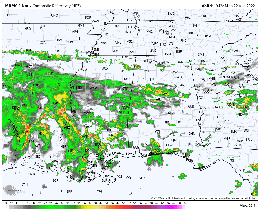
RADAR CHECK: Large areas of light to moderate rain are moving across Alabama this afternoon as the unsettled weather pattern continues across the state. Because of clouds and showers, temperatures have been holding in the 70s in many areas; the average high for Birmingham on August 22 is 90. Periods of rain will continue statewide tonight with some thunder in a few spots.
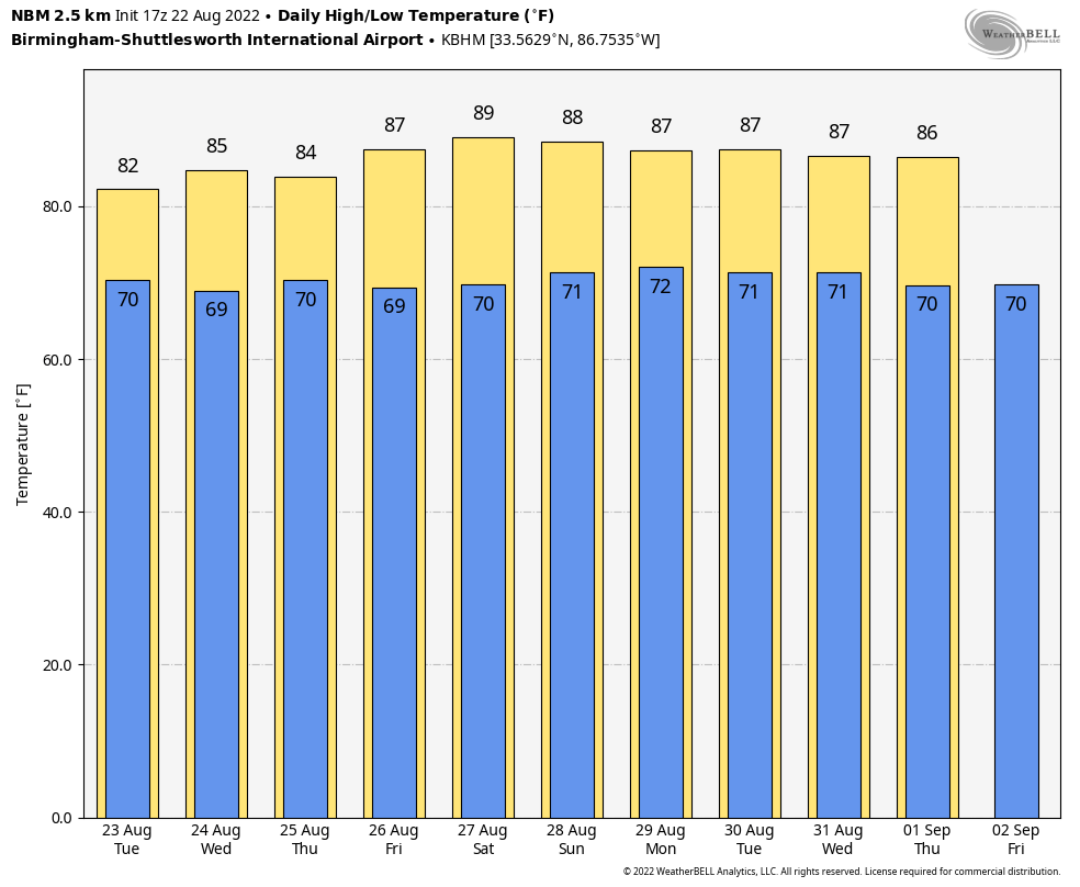
REST OF THE WEEK: Scattered to numerous showers and thunderstorms are likely again tomorrow with more clouds than sun, but showers and storms should become more scattered in nature over latter half of the week as the air slowly becomes more stable. The high tomorrow will be around 80 degrees, then we rise into the mid to upper 80s Wednesday through Friday with a mix of sun and clouds. Odds of any one spot getting wet tomorrow are 60-70 percent, and in the 35-45 percent range Wednesday through Friday.
THE ALABAMA WEEKEND: For now it looks like a fairly routine late summer weekend, with partly sunny days and the threat of scattered showers and thunderstorms, most active from around noon to midnight. The high Saturday and Sunday will be in the upper 80s in most spots, just below average for late August in Alabama. The showers and storms will be totally random, and no way of knowing in advance exactly when and where they form; you have to watch radar trends.
NEXT WEEK: Not much change through the week. Partly sunny days with the daily round of “scattered, mostly afternoon and evening showers and thunderstorms”. Highs will hold in the upper 80s on most days… See the daily Weather Briefing video for maps, graphics, and more details.
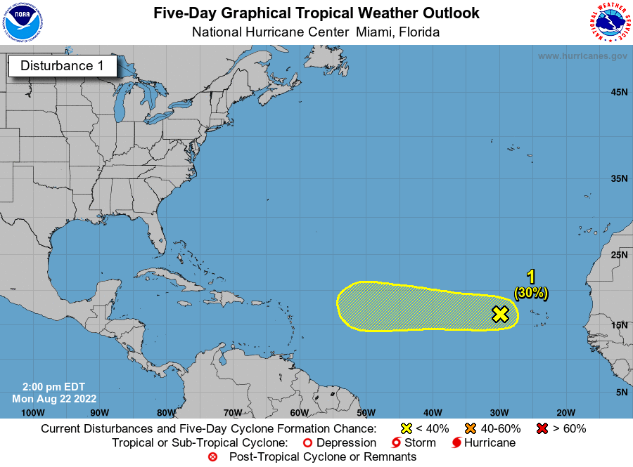
TROPICS: Showers and thunderstorms have become a little more concentrated today in association with a tropical wave located a few hundred miles west of the Cabo Verde Islands. Environmental conditions could support some slow development of this system while it moves westward to west-northwestward at around 10 to 15 mph across the tropical Atlantic during the next several days. The wave is far from land, and NHC gives it a 30 percent chance of development over the next five days. The rest of the Atlantic basin, including the Gulf of Mexico, remains very quiet.
ON THIS DATE IN 1994: Hurricane John, about 345 miles south of Hilo, Hawaii had winds of 175 mph and pressure at 920 millibars or 27.17 inches of mercury, making it one of the strongest hurricanes ever in the Central Pacific. The 31-day existence made John the longest-lasting tropical cyclone recorded in both the Pacific Ocean and worldwide, surpassing both Hurricane Tina’s previous record in the Pacific of 24 days in the 1992 season and the 1899 San Ciriaco hurricane’s previous world record of 28 days in the 1899 Atlantic season.
ON THIS DATE IN 2021: Henri mad landfall at Westerly, Rhode Island as a tropical storm, making it the second tropical cyclone to make landfall in the U.S. state of Rhode Island during the season, seven weeks after Elsa.
BEACH FORECAST: Click here to see the AlabamaWx Beach Forecast Center page.
Look for the next Weather Briefing video here by 6:00 a.m. tomorrow…
Category: Alabama's Weather, ALL POSTS, Weather Xtreme Videos
About the Author (Author Profile)
James Spann is one of the most recognized and trusted television meteorologists in the industry. He holds the AMS CCM designation and television seals from the AMS and NWA. He is a past winner of the Broadcast Meteorologist of the Year from both professional organizations.Subscribe
If you enjoyed this article, subscribe to receive more just like it.


