

Scattered To Numerous Showers/Storms Again Today
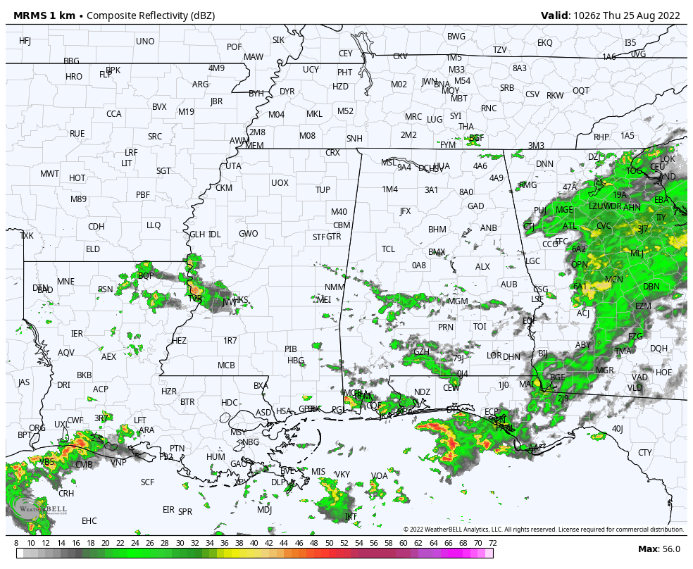
UNSETTLED PATTERN CONTINUES: We have scattered showers early this morning over the southern half of Alabama… otherwise the sky is mostly cloudy as the day begins with temperatures in the low 70s. Clouds will hang tough over much of the state, and we project another day with scattered to numerous showers and thunderstorms. We note a flash flood watch is in effect for parts of West and Southwest Alabama… from near Livingston, Greensboro, and Marion south to Mobile and Baldwin counties. This is where some places saw around 5 inches of rain yesterday, and the ground there is totally saturated. Temperatures will hold in the 70s much of the day due to clouds and showers.
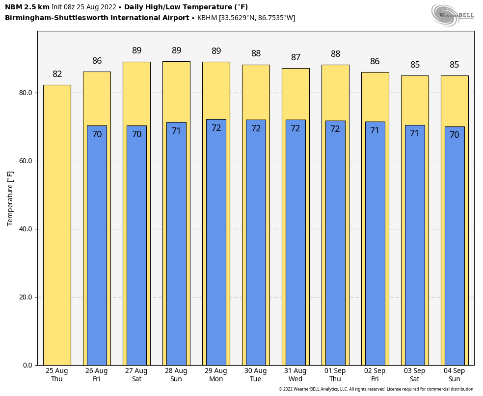
TOMORROW AND THE WEEKEND: Showers and thunderstorms will become a little less numerous by the weekend as the air will be a bit more stable. Odds of any one spot seeing rain tomorrow are still in the 65-75 percent range, but dropping to 30-40 percent Saturday and Sunday. The high tomorrow will be around 80 degrees with a generally cloudy sky, but we rise into the mid to upper 80s over the weekend with a mix of sun and clouds. Most (but not all) of the showers Saturday and Sunday will come in the noon to midnight time frame.
NEXT WEEK: We expect partly sunny days with scattered showers and thunderstorms around, mostly during the afternoon and evening hours. Highs will be in the upper 80s most days… fairly routine weather for the end of August. Still too early for a specific forecast for the Labor Day weekend, but we still see no evidence of any high impact weather event across the Deep South. See the daily Weather Briefing video for maps, graphics, and more details.
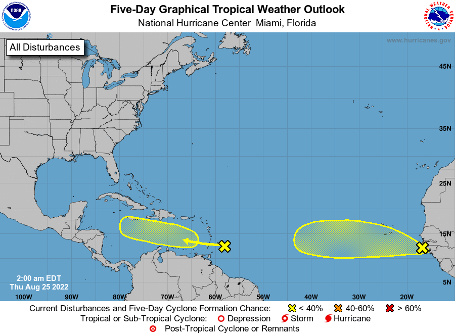
TROPICS: NHC continue to monitor two tropical waves. One is approaching the Windward Islands; shower and thunderstorm activity remains disorganized in that area. Environmental conditions could become more conducive for slow development of this system in several days after it crosses the Windward Islands and moves across the eastern and central Caribbean Sea late this week into early next week.
The other tropical wave is currently moving off the west coast of Africa. Environmental conditions could support some slow development of this system later this week or over the weekend while it moves westward at 10 to 15 mph.
For both waves, NHC gives only a 20 percent chance of development over the next five days, and the rest of the Atlantic basin remains very quiet.
FOOTBALL WEATHER: For the high school games tomorrow night, a few scattered showers will be around, mostly during the first half of the games. It won’t rain at every stadium, but I would take the rain gear. Temperatures will be near 80 at kickoff, falling into the upper 70s during the second half.
Saturday, Jacksonville State will take on Stephen F. Austin at Cramton Bowl in Montgomery (2:30p CT kickoff on ESPN)… the sky will be partly sunny with some risk of a passing shower or storm during the game. Kickoff temperature near 87, falling back into the low 80s by the final whistle.
ON THIS DATE IN 1814: A strong tornado moved through Washington D.C. The severe storm arrived the day after the British Troops had set fire to the Capitol, the White House, and other public buildings. The storm’s rains would douse those flames. The tornado did major structural damage to the residential section of the city. The tornado’s flying debris killed more British soldiers than by the guns of the American resistance. The storm blew off roofs and carried them high up into the air, knocked down chimneys and fences and damaged numerous homes. Some homes were destroyed. It lifted two pieces of cannon and deposited them several yards away. At least 30 Americans were killed or injured in the heavily damaged buildings, and an unknown number of British killed and wounded.
ON THIS DATE IN 2017: Hurricane Harvey made landfall along the Middle Texas Coast at category four strength. It caused catastrophic flooding and more than 100 deaths. It is tied with 2005’s Hurricane Katrina as the costliest tropical cyclone on record, inflicting $125 billion in damage, primarily from severe rainfall-triggered flooding in the Houston metropolitan area and Southeast Texas. With peak accumulations of 60.58 in in Nederland, Texas, Harvey was the wettest tropical cyclone on record in the United States. The resulting floods inundated hundreds of thousands of homes, which displaced more than 30,000 people and prompted more than 17,000 rescues.
BEACH FORECAST: Click here to see the AlabamaWx Beach Forecast Center page.
Look for the next Weather Briefing video here by 3:00 this afternoon… enjoy the day!
Category: Alabama's Weather, ALL POSTS, Weather Xtreme Videos
About the Author (Author Profile)
James Spann is one of the most recognized and trusted television meteorologists in the industry. He holds the AMS CCM designation and television seals from the AMS and NWA. He is a past winner of the Broadcast Meteorologist of the Year from both professional organizations.Subscribe
If you enjoyed this article, subscribe to receive more just like it.


